Mondreville (Mondreville)

- commune in Yvelines, France
- Country:

- Postal Code: 78980
- Coordinates: 48° 54' 12" N, 1° 33' 11" E


- GPS tracks (wikiloc): [Link]
- Area: 4.4 sq km
- Population: 406
- Web site: http://www.mondreville78.fr
- Wikipedia en: wiki(en)
- Wikipedia: wiki(fr)
- Wikidata storage: Wikidata: Q966503
- Wikipedia Commons Category: [Link]
- Freebase ID: [/m/03qg21r]
- Freebase ID: [/m/03qg21r]
- GeoNames ID: Alt: [6444028]
- GeoNames ID: Alt: [6444028]
- SIREN number: [217804137]
- SIREN number: [217804137]
- BnF ID: [15276037f]
- BnF ID: [15276037f]
- INSEE municipality code: 78413
- INSEE municipality code: 78413
Shares border with regions:

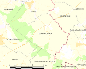
Le Mesnil-Simon
- commune in Eure-et-Loir, France
- Country:
- Postal Code: 28260
- Coordinates: 48° 53' 46" N, 1° 32' 13" E
- GPS tracks (wikiloc): [Link]
- Area: 9.17 sq km
- Population: 605
- Web site: [Link]

Gilles
- commune in Eure-et-Loir, France
- Country:
- Postal Code: 28260
- Coordinates: 48° 54' 50" N, 1° 30' 52" E
- GPS tracks (wikiloc): [Link]
- Area: 7.26 sq km
- Population: 535
- Web site: [Link]


Longnes
- commune in Yvelines, France
- Country:
- Postal Code: 78980
- Coordinates: 48° 55' 15" N, 1° 35' 15" E
- GPS tracks (wikiloc): [Link]
- Area: 13.76 sq km
- Population: 1440
- Web site: [Link]


Flins-Neuve-Église
- commune in Yvelines, France
- Country:
- Postal Code: 78790
- Coordinates: 48° 53' 28" N, 1° 34' 45" E
- GPS tracks (wikiloc): [Link]
- Area: 1.23 sq km
- Population: 157


Tilly
- commune in Yvelines, France
- Country:
- Postal Code: 78790
- Coordinates: 48° 52' 56" N, 1° 34' 33" E
- GPS tracks (wikiloc): [Link]
- Area: 7.8 sq km
- Population: 540