Mongaillard (Mongaillard)

- commune in Lot-et-Garonne, France
- Country:

- Postal Code: 47230
- Coordinates: 44° 12' 25" N, 0° 17' 37" E


- GPS tracks (wikiloc): [Link]
- Area: 8.53 sq km
- Population: 184
- Wikipedia en: wiki(en)
- Wikipedia: wiki(fr)
- Wikidata storage: Wikidata: Q1105120
- Wikipedia Commons Category: [Link]
- Freebase ID: [/m/03qm25s]
- GeoNames ID: Alt: [6435008]
- SIREN number: [214701765]
- BnF ID: [152612576]
- INSEE municipality code: 47176
Shares border with regions:


Xaintrailles
- commune in Lot-et-Garonne, France
- Country:
- Postal Code: 47230
- Coordinates: 44° 12' 20" N, 0° 15' 30" E
- GPS tracks (wikiloc): [Link]
- Area: 10.26 sq km
- Population: 416

Lavardac
- commune in Lot-et-Garonne, France
- Country:
- Postal Code: 47230
- Coordinates: 44° 10' 37" N, 0° 17' 49" E
- GPS tracks (wikiloc): [Link]
- Area: 15.1 sq km
- Population: 2230

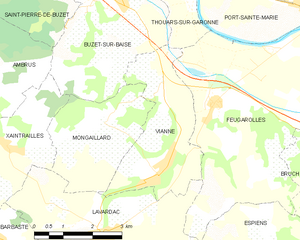
Vianne
- commune in Lot-et-Garonne, France
- Country:
- Postal Code: 47230
- Coordinates: 44° 11' 49" N, 0° 19' 16" E
- GPS tracks (wikiloc): [Link]
- Area: 9.82 sq km
- Population: 1029
- Web site: [Link]


Buzet-sur-Baïse
- commune in Lot-et-Garonne, France
- Country:
- Postal Code: 47160
- Coordinates: 44° 15' 29" N, 0° 17' 57" E
- GPS tracks (wikiloc): [Link]
- Area: 21.15 sq km
- Population: 1308
- Web site: [Link]