Montabon (Montabon)

- former commune in Sarthe, France
- Country:

- Postal Code: 72500
- Coordinates: 47° 40' 48" N, 0° 23' 12" E


- GPS tracks (wikiloc): [Link]
- Area: 7.48 sq km
- Population: 799
- Wikipedia en: wiki(en)
- Wikipedia: wiki(fr)
- Wikidata storage: Wikidata: Q532154
- Wikipedia Commons Category: [Link]
- Freebase ID: [/m/03qj062]
- GeoNames ID: Alt: [6442626]
- BnF ID: [15273758m]
- INSEE municipality code: 72203
Shares border with regions:


Luceau
- commune in Sarthe, France
- Country:
- Postal Code: 72500
- Coordinates: 47° 42' 42" N, 0° 23' 49" E
- GPS tracks (wikiloc): [Link]
- Area: 18.77 sq km
- Population: 1239


Vaas
- commune in Sarthe, France
- Country:
- Postal Code: 72500
- Coordinates: 47° 40' 9" N, 0° 18' 44" E
- GPS tracks (wikiloc): [Link]
- Area: 30.14 sq km
- Population: 1522
- Web site: [Link]
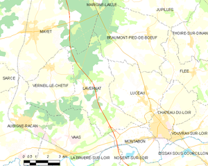
Lavernat
- commune in Sarthe, France
- Country:
- Postal Code: 72500
- Coordinates: 47° 43' 4" N, 0° 19' 58" E
- GPS tracks (wikiloc): [Link]
- Area: 22.64 sq km
- Population: 615
- Web site: [Link]

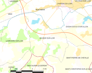
Nogent-sur-Loir
- commune in Sarthe, France
- Country:
- Postal Code: 72500
- Coordinates: 47° 40' 8" N, 0° 23' 48" E
- GPS tracks (wikiloc): [Link]
- Area: 10.81 sq km
- Population: 375


Dissay-sous-Courcillon
- commune in Sarthe, France
- Country:
- Postal Code: 72500
- Coordinates: 47° 39' 52" N, 0° 28' 21" E
- GPS tracks (wikiloc): [Link]
- Area: 34.92 sq km
- Population: 951


La Bruère-sur-Loir
- commune in Sarthe, France
- Country:
- Postal Code: 72420
- Coordinates: 47° 39' 5" N, 0° 20' 56" E
- GPS tracks (wikiloc): [Link]
- Area: 11.47 sq km
- Population: 250


Château-du-Loir
- former commune in Sarthe, France
- Country:
- Postal Code: 72500
- Coordinates: 47° 41' 36" N, 0° 25' 5" E
- GPS tracks (wikiloc): [Link]
- Area: 11.46 sq km
- Population: 4750
- Web site: [Link]