Montaillé (Montaillé)

- commune in Sarthe, France
- Country:

- Postal Code: 72120
- Coordinates: 47° 56' 16" N, 0° 42' 4" E


- GPS tracks (wikiloc): [Link]
- Area: 30.18 sq km
- Population: 553
- Wikipedia en: wiki(en)
- Wikipedia: wiki(fr)
- Wikidata storage: Wikidata: Q305201
- Wikipedia Commons Category: [Link]
- Freebase ID: [/m/03qj06f]
- GeoNames ID: Alt: [6442627]
- SIREN number: [217202043]
- BnF ID: [15273759z]
- INSEE municipality code: 72204
Shares border with regions:


Coudrecieux
- commune in Sarthe, France
- Country:
- Postal Code: 72440
- Coordinates: 47° 59' 33" N, 0° 37' 48" E
- GPS tracks (wikiloc): [Link]
- Area: 24.27 sq km
- Population: 631

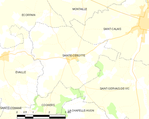
Sainte-Cérotte
- commune in Sarthe, France
- Country:
- Postal Code: 72120
- Coordinates: 47° 54' 2" N, 0° 41' 15" E
- GPS tracks (wikiloc): [Link]
- Area: 14.36 sq km
- Population: 318


Conflans-sur-Anille
- commune in Sarthe, France
- Country:
- Postal Code: 72120
- Coordinates: 47° 56' 45" N, 0° 44' 44" E
- GPS tracks (wikiloc): [Link]
- Area: 30.8 sq km
- Population: 533
- Web site: [Link]

Écorpain
- commune in Sarthe, France
- Country:
- Postal Code: 72120
- Coordinates: 47° 56' 13" N, 0° 39' 43" E
- GPS tracks (wikiloc): [Link]
- Area: 21.26 sq km
- Population: 297


Saint-Calais
- commune in Sarthe, France
- Country:
- Postal Code: 72120
- Coordinates: 47° 55' 13" N, 0° 44' 35" E
- GPS tracks (wikiloc): [Link]
- Area: 22.76 sq km
- Population: 3281
- Web site: [Link]


Semur-en-Vallon
- commune in Sarthe, France
- Country:
- Postal Code: 72390
- Coordinates: 48° 1' 23" N, 0° 39' 15" E
- GPS tracks (wikiloc): [Link]
- Area: 15.13 sq km
- Population: 439