Montbéliardot (Montbéliardot)

- commune in Doubs, France
 Hiking in Montbéliardot
Montbéliardot is a beautiful area that is not widely known among hikers, but it offers natural beauty, picturesque landscapes, and opportunities for outdoor activities. While detailed hiking trails may not be specifically documented for Montbéliardot, the surrounding regions in the Doubs department and nearby areas can provide excellent hiking experiences.
Hiking Opportunities Near Montbéliardot:
-
Forests and Nature Reserves: The area is characterized by lush forests and several nature reserves that allow for hikes through diverse ecosystems. The nearby forests offer well-marked trails where you can explore the local flora and fauna.
-
Scenic Trails: If you venture further afield, you can find scenic trails that give you views of the rolling hills and rivers typical of the Jura region. The GR (Grande Randonnée) hiking paths can also be accessed not too far from Montbéliardot.
-
Cultural and Historical Sites: While hiking, you may come across historical sites and charming villages that add to the hiking experience. Consider planning routes that incorporate visits to these cultural landmarks.
-
Local Wildlife: Bring your binoculars if you're interested in bird watching or observing local wildlife. The region is home to diverse animals and bird species.
Tips for Hiking in Montbéliardot:
-
Trail Maps: It's a good idea to have a detailed map of the area or use a hiking app to navigate the trails. Local tourist offices often provide maps and information.
-
Weather Preparedness: Be aware of the weather conditions and prepare accordingly. The Jura region can have variable weather, so dressing in layers is advisable.
-
Safety First: Always let someone know your hiking plan, especially if you are heading into less populated areas. Carry a first-aid kit, sufficient water, and snacks.
-
Respect Nature: Follow Leave No Trace principles. Stay on marked trails, pack out what you bring in, and be respectful of wildlife.
For a comprehensive hiking experience, consider visiting nearby popular hiking destinations such as the Doubs Valley or the Jura mountains. Be sure to check local resources or hiking clubs for current trails and advice! Enjoy your hiking adventure!
- Country:

- Postal Code: 25210
- Coordinates: 47° 10' 31" N, 6° 39' 16" E


- GPS tracks (wikiloc): [Link]
- Area: 3.8 sq km
- Population: 114
- Wikipedia en: wiki(en)
- Wikipedia: wiki(fr)
- Wikidata storage: Wikidata: Q643285
- Wikipedia Commons Category: [Link]
- Freebase ID: [/m/03mhbh_]
- Freebase ID: [/m/03mhbh_]
- GeoNames ID: Alt: [6429886]
- GeoNames ID: Alt: [6429886]
- SIREN number: [212503890]
- SIREN number: [212503890]
- BnF ID: [15252615d]
- BnF ID: [15252615d]
- INSEE municipality code: 25389
- INSEE municipality code: 25389
Shares border with regions:

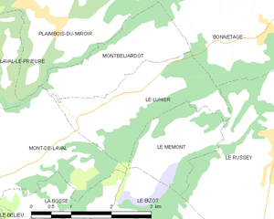
Le Luhier
- commune in Doubs, France
Hiking in Le Luhier
Le Luhier is a picturesque region that offers a variety of hiking trails for both beginners and experienced hikers. Nestled in nature, this area features stunning landscapes, including dense forests, rolling hills, and picturesque streams. While I don’t have specific details on Le Luhier itself, I can give you some general tips and advice for hiking in such areas....
- Country:
- Postal Code: 25210
- Coordinates: 47° 10' 6" N, 6° 39' 34" E
- GPS tracks (wikiloc): [Link]
- Area: 5.21 sq km
- Population: 212


Bonnétage
- commune in Doubs, France
Hiking in Bonnétage
Bonnétage, located in the Doubs department of the Bourgogne-Franche-Comté region in eastern France, is a beautiful destination for hiking enthusiasts. Nestled in the Jura Mountains, the area offers stunning landscapes, lush forests, and panoramic views, making it an ideal location for outdoor activities....
- Country:
- Postal Code: 25210
- Coordinates: 47° 11' 5" N, 6° 43' 24" E
- GPS tracks (wikiloc): [Link]
- Area: 17.71 sq km
- Population: 887

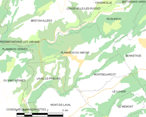
Plaimbois-du-Miroir
- commune in Doubs, France
Hiking in Plaimbois-du-Miroir
Plaimbois-du-Miroir is a charming village located in the Jura region of France, known for its picturesque landscapes and outdoor activities, including hiking. The Jura Mountains offer a variety of trails that cater to hikers of different skill levels. Here are some highlights:...
- Country:
- Postal Code: 25210
- Coordinates: 47° 11' 29" N, 6° 38' 43" E
- GPS tracks (wikiloc): [Link]
- Area: 11.71 sq km
- Population: 238


Mont-de-Laval
- commune in Doubs, France
Hiking in Mont-de-Laval
Mont-de-Laval is situated in the beautiful region of the French Alps, and offers a variety of hiking opportunities that cater to different skill levels. Here are some highlights regarding hiking in the area:...
- Country:
- Postal Code: 25210
- Coordinates: 47° 10' 10" N, 6° 37' 41" E
- GPS tracks (wikiloc): [Link]
- Area: 8.44 sq km
- Population: 173