Montberon (Montberon)

- commune in Haute-Garonne, France
- Country:

- Postal Code: 31140
- Coordinates: 43° 42' 56" N, 1° 28' 49" E


- GPS tracks (wikiloc): [Link]
- Area: 6.35 sq km
- Population: 2898
- Web site: http://www.montberon.fr
- Wikipedia en: wiki(en)
- Wikipedia: wiki(fr)
- Wikidata storage: Wikidata: Q835592
- Wikipedia Commons Category: [Link]
- Freebase ID: [/m/03nq2bb]
- Freebase ID: [/m/03nq2bb]
- GeoNames ID: Alt: [6431703]
- GeoNames ID: Alt: [6431703]
- SIREN number: [213103641]
- SIREN number: [213103641]
- BnF ID: [15255359x]
- BnF ID: [15255359x]
- INSEE municipality code: 31364
- INSEE municipality code: 31364
Shares border with regions:


Villariès
- commune in Haute-Garonne, France
- Country:
- Postal Code: 31380
- Coordinates: 43° 45' 12" N, 1° 29' 31" E
- GPS tracks (wikiloc): [Link]
- Area: 7.33 sq km
- Population: 812
Saint-Loup-Cammas
- commune in Haute-Garonne, France
- Country:
- Postal Code: 31140
- Coordinates: 43° 41' 47" N, 1° 28' 41" E
- GPS tracks (wikiloc): [Link]
- Area: 3.65 sq km
- Population: 2084
- Web site: [Link]

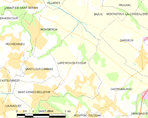
Lapeyrouse-Fossat
- commune in Haute-Garonne, France
- Country:
- Postal Code: 31180
- Coordinates: 43° 41' 31" N, 1° 30' 59" E
- GPS tracks (wikiloc): [Link]
- Area: 9.49 sq km
- Population: 2753
- Web site: [Link]


Pechbonnieu
- commune in Haute-Garonne, France
- Country:
- Postal Code: 31140
- Coordinates: 43° 42' 14" N, 1° 28' 0" E
- GPS tracks (wikiloc): [Link]
- Area: 7.52 sq km
- Population: 4416
- Web site: [Link]

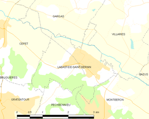
Labastide-Saint-Sernin
- commune in Haute-Garonne, France
- Country:
- Postal Code: 31620
- Coordinates: 43° 44' 20" N, 1° 28' 16" E
- GPS tracks (wikiloc): [Link]
- Area: 4.97 sq km
- Population: 1876


Bazus
- commune in Haute-Garonne, France
- Country:
- Postal Code: 31380
- Coordinates: 43° 44' 8" N, 1° 31' 3" E
- GPS tracks (wikiloc): [Link]
- Area: 9.13 sq km
- Population: 564
- Web site: [Link]