Montcresson (Montcresson)

- commune in Loiret, France
- Country:

- Postal Code: 45700
- Coordinates: 47° 54' 21" N, 2° 48' 25" E


- GPS tracks (wikiloc): [Link]
- Area: 21 sq km
- Population: 1290
- Web site: http://montcresson.com
- Wikipedia en: wiki(en)
- Wikipedia: wiki(fr)
- Wikidata storage: Wikidata: Q1422735
- Wikipedia Commons Category: [Link]
- Freebase ID: [/m/081db9]
- GeoNames ID: Alt: [2992793]
- SIREN number: [214502122]
- BnF ID: [15260604g]
- INSEE municipality code: 45212
Shares border with regions:


Gy-les-Nonains
- commune in Loiret, France
- Country:
- Postal Code: 45220
- Coordinates: 47° 56' 50" N, 2° 51' 5" E
- GPS tracks (wikiloc): [Link]
- Area: 20.13 sq km
- Population: 643


Pressigny-les-Pins
- commune in Loiret, France
- Country:
- Postal Code: 45290
- Coordinates: 47° 52' 52" N, 2° 45' 4" E
- GPS tracks (wikiloc): [Link]
- Area: 11.91 sq km
- Population: 498
- Web site: [Link]


Montbouy
- commune in Loiret, France
- Country:
- Postal Code: 45230
- Coordinates: 47° 51' 41" N, 2° 49' 12" E
- GPS tracks (wikiloc): [Link]
- Area: 26.73 sq km
- Population: 745
- Web site: [Link]


Conflans-sur-Loing
- commune in Loiret, France
- Country:
- Postal Code: 45700
- Coordinates: 47° 57' 9" N, 2° 47' 21" E
- GPS tracks (wikiloc): [Link]
- Area: 9.14 sq km
- Population: 369

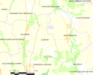
Cortrat
- commune in Loiret, France
- Country:
- Postal Code: 45700
- Coordinates: 47° 53' 48" N, 2° 45' 54" E
- GPS tracks (wikiloc): [Link]
- Area: 11.03 sq km
- Population: 82