
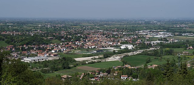
Montechiarugolo (Montechiarugolo)
.svg)
- Italian comune
 Hiking in Montechiarugolo
Montechiarugolo, located in the Emilia-Romagna region of northern Italy, is known for its beautiful landscapes, rolling hills, and rich history. While it may not be as famous for hiking as some other regions in Italy, it offers several opportunities for outdoor activities and exploration.
Here are some tips and information about hiking in and around Montechiarugolo:
Trails and Routes
-
Local Trails: The area around Montechiarugolo features various local trails that take you through vineyards, olive groves, and countryside. Some trails may be less marked, so having a map or GPS device is advisable.
-
Parco dei Boschi di Carrega: This park, located nearby, offers numerous trails among lush forests and along the Parma River. It's a great place for hiking, bird-watching, and enjoying nature.
-
Colline di Montechiarugolo: Exploring the hills surrounding Montechiarugolo provides vistas of the beautiful countryside. Some paths lead to scenic lookout points and small rural villages.
Difficulty Levels
- Beginner to Intermediate: Many trails in the region cater to varying skill levels. Beginners can enjoy relatively flat paths, while more experienced hikers can find steeper, more challenging routes.
Best Time to Hike
- Spring and Fall: These seasons offer the most pleasant weather for hiking. Spring brings blooming landscapes, while fall showcases vibrant autumn colors. Summer can be hot, so early morning hikes are recommended.
Preparation Tips
- Footwear: Comfortable, sturdy hiking shoes are essential, especially for uneven terrain.
- Water and Snacks: Always carry enough water and some snacks to keep your energy up during hikes.
- Map and Compass: Since some trails may not be well-marked, having a physical map or a GPS app can be very useful.
Local Attractions
- After a day of hiking, consider visiting Montechiarugolo’s historic center, which has charming architecture, and local eateries that serve Emilia-Romagna’s delicious cuisine.
Hiking Groups
- If you're interested in hiking with others, check local hiking clubs and community groups, which may offer guided hikes and activities.
By exploring hiking options in and around Montechiarugolo, you can enjoy both the natural beauty and cultural heritage of this lovely Italian region. Happy hiking!
- Country:

- Postal Code: 43022
- Local Dialing Code: 0521
- Licence Plate Code: PR
- Coordinates: 44° 41' 36" N, 10° 25' 21" E


- GPS tracks (wikiloc): [Link]
- AboveSeaLevel: 128 м m
- Area: 48.2 sq km
- Population: 10976
- Web site: http://www.comune.montechiarugolo.pr.it
- Wikipedia en: wiki(en)
- Wikipedia: wiki(it)
- Wikidata storage: Wikidata: Q100846
- Wikipedia Commons Category: [Link]
- Freebase ID: [/m/0gkdq2]
- GeoNames ID: Alt: [6538425]
- VIAF ID: Alt: [141088367]
- OSM relation ID: [43458]
- GND ID: Alt: [4663479-4]
- Library of Congress authority ID: Alt: [no2006079683]
- UN/LOCODE: [ITHRG]
- ISTAT ID: 034023
- Italian cadastre code: F473
Shares border with regions:

Traversetolo
- Italian comune
Hiking in Traversetolo
Traversetolo is a picturesque municipality located in the Emilia-Romagna region of Italy, surrounded by beautiful landscapes, rolling hills, and a rich variety of outdoor activities, including hiking. Although it may not be as well-known as some other Italian hiking destinations, it offers some delightful trails that allow you to experience the local flora, fauna, and stunning views of the surrounding countryside....
- Country:
- Postal Code: 43029
- Local Dialing Code: 0521
- Licence Plate Code: PR
- Coordinates: 44° 38' 24" N, 10° 22' 54" E
- GPS tracks (wikiloc): [Link]
- AboveSeaLevel: 176 м m
- Area: 54.86 sq km
- Population: 9474
- Web site: [Link]


Montecchio Emilia
- Italian comune
Hiking in Montecchio Emilia
Montecchio Emilia, located in the Emilia-Romagna region of Italy, offers a variety of hiking opportunities that showcase the beautiful landscapes, historical sites, and charming countryside of the area. Here are some key points to consider for hiking in this region:...
- Country:
- Postal Code: 42027
- Local Dialing Code: 0522
- Licence Plate Code: RE
- Coordinates: 44° 41' 55" N, 10° 26' 55" E
- GPS tracks (wikiloc): [Link]
- AboveSeaLevel: 99 м m
- Area: 24.39 sq km
- Population: 10578
- Web site: [Link]


San Polo d'Enza
- Italian comune
Hiking in San Polo d'Enza
San Polo d'Enza is a charming village located in the Emilia-Romagna region of Italy, nestled between the Apennine mountains and the Po Valley. It's a great starting point for hikers looking to explore the natural beauty of this area, which is characterized by rolling hills, lush forests, and scenic vistas....
- Country:
- Postal Code: 42020
- Local Dialing Code: 0522
- Licence Plate Code: RE
- Coordinates: 44° 38' 0" N, 10° 26' 0" E
- GPS tracks (wikiloc): [Link]
- AboveSeaLevel: 174 м m
- Area: 32.29 sq km
- Population: 6156
- Web site: [Link]


Sant'Ilario d'Enza
- Italian comune
Hiking in Sant'Ilario d'Enza
Sant'Ilario d'Enza is a charming town located in the Emilia-Romagna region of Italy, and while it may not be as well-known as some other hiking destinations, it offers beautiful landscapes and opportunities for outdoor activities. Here are some insights into hiking in and around Sant'Ilario d'Enza:...
- Country:
- Postal Code: 42049
- Local Dialing Code: 0522
- Licence Plate Code: RE
- Coordinates: 44° 46' 0" N, 10° 27' 0" E
- GPS tracks (wikiloc): [Link]
- AboveSeaLevel: 59 м m
- Area: 20.23 sq km
- Population: 11263
- Web site: [Link]


Parma
- city in the northern Italian region of Emilia-Romagna
Hiking in Parma
Parma, located in northern Italy, is not just known for its rich culinary heritage, but it also offers beautiful hiking opportunities in its surroundings. The region is characterized by rolling hills, lush landscapes, and a variety of trails suitable for different levels of hikers....
- Country:
- Postal Code: 43121–43126
- Local Dialing Code: 0521
- Licence Plate Code: PR
- Coordinates: 44° 48' 5" N, 10° 19' 41" E
- GPS tracks (wikiloc): [Link]
- AboveSeaLevel: 55 м m
- Area: 260.6 sq km
- Population: 194417
- Web site: [Link]