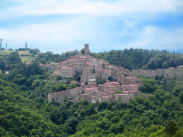
Montieri (Montieri)
.svg)
- Italian comune
 Hiking in Montieri
Montieri is a charming town located in the province of Grosseto in Tuscany, Italy. It's situated in a picturesque setting surrounded by lush forests, rolling hills, and scenic landscapes which make it a great destination for hikers and nature enthusiasts. Here are some key points about hiking in the Montieri area:
Trails and Routes:
-
Variety of Trails: Montieri offers a range of hiking trails suitable for different skill levels, from easy walks to more challenging hikes. You can explore forest paths, hills, and scenic viewpoints.
-
Natural Parks: The nearby Cornate e Fosini Nature Reserve is a great place to hike, featuring rich biodiversity and stunning landscapes. The trails here often showcase local flora and fauna.
-
Historic Routes: Some trails in the area may lead you to historical sites, such as ancient ruins or old mining sites, reflecting the region's history and heritage.
-
Gorgeous Views: Many hiking paths provide stunning panoramic views of the surrounding countryside, vineyards, and medieval villages typical of the Tuscan landscape.
Tips for Hiking in Montieri:
-
Weather Preparation: Always check the weather forecast before your hike, as conditions can change rapidly in mountainous areas. Late spring and early fall are often the best times for hiking, with milder temperatures.
-
Trail Maps: Consider obtaining a trail map or using outdoor apps for navigation, as some trails may not be well-marked.
-
Safety Gear: Bring appropriate hiking gear, including sturdy shoes, a hat, sunscreen, and plenty of water. A basic first aid kit can also be beneficial.
-
Local Guidance: If you're unsure about trails, consider joining a guided hiking tour. Local guides can provide insights into the area's ecology, history, and culture.
-
Respect Nature: Always practice Leave No Trace principles to minimize your impact on the environment. Stay on designated paths and avoid disturbing wildlife.
Additional Activities:
Aside from hiking, Montieri and the surrounding areas offer other outdoor activities like mountain biking, bird watching, and exploring local wineries and farms.
In summary, Montieri provides a beautiful location for hiking, with diverse trails that cater to various skill levels. The natural beauty and rich history of the region make for an enriching hiking experience.
- Country:

- Postal Code: 58026
- Local Dialing Code: 0566
- Licence Plate Code: GR
- Coordinates: 43° 7' 52" N, 11° 1' 0" E


- GPS tracks (wikiloc): [Link]
- AboveSeaLevel: 704 м m
- Area: 108.21 sq km
- Population: 1171
- Web site: http://www.comune.montieri.gr.it
- Wikipedia en: wiki(en)
- Wikipedia: wiki(it)
- Wikidata storage: Wikidata: Q214841
- Wikipedia Commons Gallery: [Link]
- Wikipedia Commons Category: [Link]
- Freebase ID: [/m/0gm1fr]
- GeoNames ID: Alt: [6536860]
- VIAF ID: Alt: [239239391]
- OSM relation ID: [42316]
- GND ID: Alt: [7653737-7]
- Quora topic ID: [Montieri]
- ISTAT ID: 053017
- Italian cadastre code: F677
Includes regions:

Travale
- human settlement in Italy
Hiking in Travale
Travale is a charming destination for hiking enthusiasts, known for its picturesque landscapes and serene nature. While specific hiking trails may vary, here are some general features and recommendations for hiking in the Travale area:...
- Country:
- Postal Code: 58020
- Local Dialing Code: 0566
- Coordinates: 43° 10' 2" N, 11° 0' 30" E
- GPS tracks (wikiloc): [Link]
- AboveSeaLevel: 520 м m

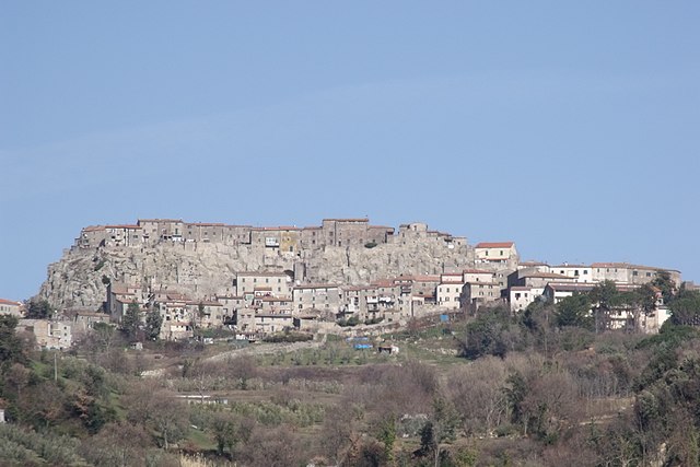
Boccheggiano
- village in the commune of Montieri, Italy
Hiking in Boccheggiano
Boccheggiano, a charming village in the heart of Tuscany, Italy, offers a wonderful backdrop for hiking enthusiasts. Nestled in the hills of the Maremma region, it provides access to a variety of trails that cater to different skill levels and preferences....
- Country:
- Postal Code: 58026
- Local Dialing Code: 0566
- Coordinates: 43° 5' 25" N, 11° 2' 1" E
- GPS tracks (wikiloc): [Link]
- AboveSeaLevel: 664 м m

Gerfalco
- human settlement in Italy
Hiking in Gerfalco
Gerfalco is a small village located in the Tuscany region of Italy, known for its beautiful landscapes and outdoor activities, including hiking. The region offers a variety of trails that cater to different skill levels, making it an excellent destination for both novice and experienced hikers....
- Country:
- Postal Code: 58020
- Local Dialing Code: 0566
- Coordinates: 43° 8' 47" N, 10° 58' 46" E
- GPS tracks (wikiloc): [Link]
- AboveSeaLevel: 774 м m
Shares border with regions:
Castelnuovo di Val di Cecina
- Italian comune
Hiking in Castelnuovo di Val di Cecina
Castelnuovo di Val di Cecina is located in Tuscany, Italy, and is known for its picturesque landscapes, rich history, and well-preserved natural environments. Hiking in this area offers a unique experience, with trails that wind through beautiful countryside, medieval villages, and stunning vistas....
- Country:
- Postal Code: 56041
- Local Dialing Code: 0588
- Licence Plate Code: PI
- Coordinates: 43° 13' 0" N, 10° 54' 0" E
- GPS tracks (wikiloc): [Link]
- AboveSeaLevel: 576 м m
- Area: 89.02 sq km
- Population: 2182
- Web site: [Link]


Monterotondo Marittimo
- Italian comune
Hiking in Monterotondo Marittimo
Monterotondo Marittimo is a charming hilltop village located in the province of Grosseto, Tuscany, Italy. It's surrounded by beautiful natural landscapes, making it a great destination for hiking enthusiasts....
- Country:
- Postal Code: 58025
- Local Dialing Code: 0566
- Licence Plate Code: GR
- Coordinates: 43° 8' 46" N, 10° 51' 20" E
- GPS tracks (wikiloc): [Link]
- AboveSeaLevel: 539 м m
- Area: 102.59 sq km
- Population: 1313
- Web site: [Link]


Massa Marittima
- Italian comune
Hiking in Massa Marittima
Massa Marittima is a charming medieval town located in Tuscany, Italy, and it's surrounded by beautiful landscapes that are ideal for hiking. The region offers a variety of trails, suitable for different skill levels, ranging from easy walks to more challenging hikes. Here are some key highlights about hiking in the area:...
- Country:
- Postal Code: 58024
- Local Dialing Code: 0566
- Licence Plate Code: GR
- Coordinates: 43° 3' 0" N, 10° 53' 37" E
- GPS tracks (wikiloc): [Link]
- AboveSeaLevel: 380 м m
- Area: 283.45 sq km
- Population: 8286
- Web site: [Link]

Roccastrada
- Italian comune
Hiking in Roccastrada
Roccastrada, located in the southern part of the Tuscany region in Italy, is an excellent destination for hiking enthusiasts. The area is characterized by its beautiful landscapes, rolling hills, and rich natural and cultural heritage. Here are some highlights to consider when hiking in Roccastrada:...
- Country:
- Postal Code: 58036
- Local Dialing Code: 0564
- Licence Plate Code: GR
- Coordinates: 43° 0' 35" N, 11° 10' 6" E
- GPS tracks (wikiloc): [Link]
- AboveSeaLevel: 475 м m
- Area: 284.47 sq km
- Population: 9074
- Web site: [Link]


Chiusdino
- Italian comune
Hiking in Chiusdino
Chiusdino is a charming village located in the Province of Siena in Tuscany, Italy, surrounded by beautiful landscapes that make it a fantastic destination for hiking enthusiasts. The area is rich in natural beauty, history, and culture, providing a great backdrop for outdoor activities....
- Country:
- Postal Code: 53012
- Local Dialing Code: 0577
- Licence Plate Code: SI
- Coordinates: 43° 9' 17" N, 11° 5' 3" E
- GPS tracks (wikiloc): [Link]
- AboveSeaLevel: 564 м m
- Area: 141.62 sq km
- Population: 1877
- Web site: [Link]


Radicondoli
- Italian comune
Hiking in Radicondoli
Radicondoli is a charming village located in the province of Siena, Tuscany, Italy, known for its stunning landscapes, rolling hills, and rich cultural heritage. Hiking in and around Radicondoli offers a fantastic opportunity to explore the natural beauty of the region, its picturesque vineyards, olive groves, and historical elements....
- Country:
- Postal Code: 53030
- Local Dialing Code: 0577
- Licence Plate Code: SI
- Coordinates: 43° 16' 0" N, 11° 3' 0" E
- GPS tracks (wikiloc): [Link]
- AboveSeaLevel: 509 м m
- Area: 132.57 sq km
- Population: 935
- Web site: [Link]