Montours (Montours)

- former commune in Ille-et-Vilaine, France
- Country:

- Postal Code: 35460
- Coordinates: 48° 26' 34" N, 1° 18' 32" E


- GPS tracks (wikiloc): [Link]
- Area: 15.27 sq km
- Population: 1074
- Web site: http://www.montours.fr
- Wikipedia en: wiki(en)
- Wikipedia: wiki(fr)
- Wikidata storage: Wikidata: Q1070951
- Wikipedia Commons Category: [Link]
- Freebase ID: [/m/03m9ptc]
- Freebase ID: [/m/03m9ptc]
- GeoNames ID: Alt: [6432764]
- GeoNames ID: Alt: [6432764]
- BnF ID: [15257134h]
- BnF ID: [15257134h]
- VIAF ID: Alt: [235235392]
- VIAF ID: Alt: [235235392]
- INSEE municipality code: 35191
- INSEE municipality code: 35191
Shares border with regions:

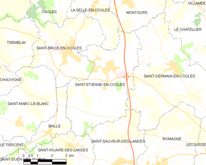
Saint-Étienne-en-Coglès
- former commune in Ille-et-Vilaine, France
- Country:
- Postal Code: 35460
- Coordinates: 48° 24' 13" N, 1° 19' 30" E
- GPS tracks (wikiloc): [Link]
- Area: 22.65 sq km
- Population: 1756
- Web site: [Link]

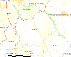
Le Ferré
- commune in Ille-et-Vilaine, France
- Country:
- Postal Code: 35420
- Coordinates: 48° 29' 33" N, 1° 17' 38" E
- GPS tracks (wikiloc): [Link]
- Area: 16.92 sq km
- Population: 689
- Web site: [Link]


La Selle-en-Coglès
- former commune in Ille-et-Vilaine, France
- Country:
- Postal Code: 35460
- Coordinates: 48° 26' 15" N, 1° 20' 41" E
- GPS tracks (wikiloc): [Link]
- Area: 8.23 sq km
- Population: 633

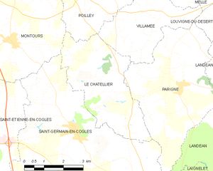
Le Châtellier
- commune in Ille-et-Vilaine, France
- Country:
- Postal Code: 35133
- Coordinates: 48° 24' 57" N, 1° 15' 15" E
- GPS tracks (wikiloc): [Link]
- AboveSeaLevel: 172 м m
- Area: 13.43 sq km
- Population: 411


Poilley
- commune in Ille-et-Vilaine, France
- Country:
- Postal Code: 35420
- Coordinates: 48° 27' 56" N, 1° 15' 45" E
- GPS tracks (wikiloc): [Link]
- Area: 10.78 sq km
- Population: 387


Coglès
- former commune in Ille-et-Vilaine, France
- Country:
- Postal Code: 35460
- Coordinates: 48° 27' 35" N, 1° 21' 51" E
- GPS tracks (wikiloc): [Link]
- Area: 17.21 sq km
- Population: 652
- Web site: [Link]


Saint-Germain-en-Coglès
- commune in Ille-et-Vilaine, France
- Country:
- Postal Code: 35133
- Coordinates: 48° 24' 21" N, 1° 15' 48" E
- GPS tracks (wikiloc): [Link]
- Area: 32.09 sq km
- Population: 2044
- Web site: [Link]