Saint-Étienne-en-Coglès (Saint-Étienne-en-Coglès)

- former commune in Ille-et-Vilaine, France
- Country:

- Postal Code: 35460
- Coordinates: 48° 24' 13" N, 1° 19' 30" E


- GPS tracks (wikiloc): [Link]
- Area: 22.65 sq km
- Population: 1756
- Web site: http://www.saint-etienne-en-cogles.fr
- Wikipedia en: wiki(en)
- Wikipedia: wiki(fr)
- Wikidata storage: Wikidata: Q1063201
- Wikipedia Commons Category: [Link]
- Freebase ID: [/m/03mf4r9]
- Freebase ID: [/m/03mf4r9]
- GeoNames ID: Alt: [6432826]
- GeoNames ID: Alt: [6432826]
- BnF ID: [15257209k]
- BnF ID: [15257209k]
- PACTOLS thesaurus ID: [pcrtGIYsWHMlli]
- PACTOLS thesaurus ID: [pcrtGIYsWHMlli]
- INSEE municipality code: 35267
- INSEE municipality code: 35267
Shares border with regions:


Baillé
- commune in Ille-et-Vilaine, France
- Country:
- Postal Code: 35460
- Coordinates: 48° 21' 34" N, 1° 22' 54" E
- GPS tracks (wikiloc): [Link]
- Area: 5.23 sq km
- Population: 297


Saint-Brice-en-Coglès
- former commune in Ille-et-Vilaine, France
- Country:
- Postal Code: 35460
- Coordinates: 48° 24' 38" N, 1° 22' 1" E
- GPS tracks (wikiloc): [Link]
- Area: 16.46 sq km
- Population: 2963
- Web site: [Link]


Montours
- former commune in Ille-et-Vilaine, France
- Country:
- Postal Code: 35460
- Coordinates: 48° 26' 34" N, 1° 18' 32" E
- GPS tracks (wikiloc): [Link]
- Area: 15.27 sq km
- Population: 1074
- Web site: [Link]


La Selle-en-Coglès
- former commune in Ille-et-Vilaine, France
- Country:
- Postal Code: 35460
- Coordinates: 48° 26' 15" N, 1° 20' 41" E
- GPS tracks (wikiloc): [Link]
- Area: 8.23 sq km
- Population: 633
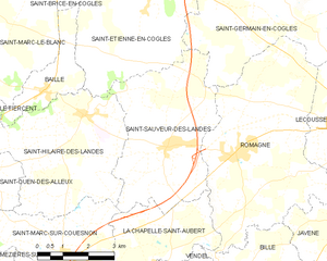
Saint-Sauveur-des-Landes
- commune in Ille-et-Vilaine, France
- Country:
- Postal Code: 35133
- Coordinates: 48° 20' 33" N, 1° 18' 49" E
- GPS tracks (wikiloc): [Link]
- Area: 18.84 sq km
- Population: 1513
- Web site: [Link]


Saint-Hilaire-des-Landes
- commune in Ille-et-Vilaine, France
- Country:
- Postal Code: 35140
- Coordinates: 48° 21' 5" N, 1° 21' 29" E
- GPS tracks (wikiloc): [Link]
- AboveSeaLevel: 115 м m
- Area: 18.27 sq km
- Population: 1032


Saint-Germain-en-Coglès
- commune in Ille-et-Vilaine, France
- Country:
- Postal Code: 35133
- Coordinates: 48° 24' 21" N, 1° 15' 48" E
- GPS tracks (wikiloc): [Link]
- Area: 32.09 sq km
- Population: 2044
- Web site: [Link]