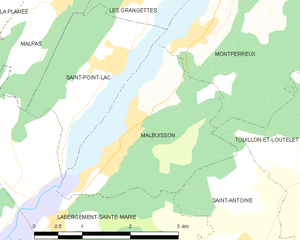
Montperreux (Montperreux)

- commune in Doubs, France
 Hiking in Montperreux
Montperreux is a picturesque destination located near Lake Neuchâtel in Switzerland. It offers stunning views and a variety of hiking trails that cater to different skill levels. Here are some key points to consider when hiking in Montperreux:
Trails:
- Variety of Options: Montperreux features several hiking trails that range from easy to moderate difficulty, making it suitable for both beginners and experienced hikers.
- Scenic Views: Trails often provide spectacular views of Lake Neuchâtel, the surrounding vineyards, and the Jura mountain range, offering great photo opportunities.
- Nature and Wildlife: The area is rich in flora and fauna, making it a great spot for nature enthusiasts. You may encounter various bird species and local wildlife along the trails.
Tips for Hiking in Montperreux:
- Weather Check: Always check the weather forecast before heading out, as conditions can change rapidly in mountainous areas.
- Footwear: Wear appropriate hiking shoes, as some trails may be uneven or rocky.
- Water and Snacks: Carry enough water and snacks, especially for longer hikes. There might not be many facilities along the trails.
- Local Maps: It’s a good idea to have a physical map or a GPS device, as cell service can be spotty in the mountains.
- Respect Nature: Follow the Leave No Trace principles to keep the trails clean and preserve the natural beauty.
Accessibility:
- Montperreux is accessible by public transport or car, making it easy to reach from nearby cities like Neuchâtel.
Local Attractions:
- After your hike, consider visiting local wineries or enjoying the lakeside promenades in Montperreux to relax and enjoy the scenery.
Whether you’re looking for a leisurely walk or a more challenging hike, Montperreux has something to offer for everyone. Enjoy the breathtaking landscapes and embrace the tranquility of the Swiss outdoors!
- Country:

- Postal Code: 25160
- Coordinates: 46° 49' 33" N, 6° 20' 31" E


- GPS tracks (wikiloc): [Link]
- Area: 11.61 sq km
- Population: 837
- Wikipedia en: wiki(en)
- Wikipedia: wiki(fr)
- Wikidata storage: Wikidata: Q909175
- Wikipedia Commons Category: [Link]
- Freebase ID: [/m/03mhbmf]
- Freebase ID: [/m/03mhbmf]
- GeoNames ID: Alt: [6429901]
- GeoNames ID: Alt: [6429901]
- SIREN number: [212504054]
- SIREN number: [212504054]
- BnF ID: [15252631n]
- BnF ID: [15252631n]
- WOEID: [612981]
- WOEID: [612981]
- INSEE municipality code: 25405
- INSEE municipality code: 25405
Shares border with regions:


La Cluse-et-Mijoux
- commune in Doubs, France
Hiking in La Cluse-et-Mijoux
La Cluse-et-Mijoux is a picturesque commune located in the Doubs department of the Bourgogne-Franche-Comté region in eastern France. Nestled in the Jura mountains, it offers beautiful landscapes, lush forests, and scenic views, making it a great destination for hiking enthusiasts....
- Country:
- Postal Code: 25300
- Coordinates: 46° 52' 19" N, 6° 22' 43" E
- GPS tracks (wikiloc): [Link]
- Area: 22.5 sq km
- Population: 1318
- Web site: [Link]


Les Hôpitaux-Vieux
- commune in Doubs, France
Hiking in Les Hôpitaux-Vieux
Les Hôpitaux-Vieux is a charming village located in the Jura region of eastern France, known for its beautiful landscapes and outdoor recreational opportunities. Hiking in this area offers a chance to explore lush forests, rolling hills, and stunning views of the Jura Mountains....
- Country:
- Postal Code: 25370
- Coordinates: 46° 47' 22" N, 6° 22' 0" E
- GPS tracks (wikiloc): [Link]
- Area: 14.21 sq km
- Population: 431


Touillon-et-Loutelet
- commune in Doubs, France
Hiking in Touillon-et-Loutelet
Touillon-et-Loutelet is a picturesque commune located in the Jura region of France, known for its beautiful landscapes and outdoor activities, including hiking. Here are some highlights and tips for hiking in this area:...
- Country:
- Postal Code: 25370
- Coordinates: 46° 47' 33" N, 6° 21' 6" E
- GPS tracks (wikiloc): [Link]
- Area: 4.72 sq km
- Population: 250

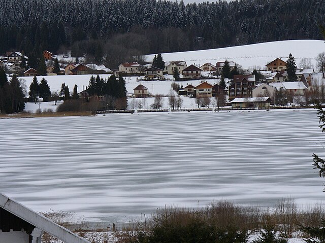
Malbuisson
- commune in Doubs, France
Hiking in Malbuisson
Malbuisson is a beautiful commune located in the Doubs department in the Bourgogne-Franche-Comté region of France, nestled beside the stunning Lake Saint-Point. This area is known for its picturesque landscapes, rolling hills, and rich natural beauty, making it an excellent destination for hiking enthusiasts....
- Country:
- Postal Code: 25160
- Coordinates: 46° 47' 53" N, 6° 18' 12" E
- GPS tracks (wikiloc): [Link]
- Area: 6.6 sq km
- Population: 855
- Web site: [Link]

Saint-Point-Lac
- commune in Doubs, France
Hiking in Saint-Point-Lac
Saint-Point-Lac is a beautiful area located in the Jura Mountains of France, known for its stunning natural scenery and diverse hiking opportunities. The region is characterized by its picturesque lake, stunning landscapes, and rich biodiversity, making it a popular destination for hikers and nature enthusiasts....
- Country:
- Postal Code: 25160
- Coordinates: 46° 48' 48" N, 6° 18' 8" E
- GPS tracks (wikiloc): [Link]
- Area: 4.52 sq km
- Population: 280


Oye-et-Pallet
- commune in Doubs, France
Hiking in Oye-et-Pallet
Oye-et-Pallet is a small commune in the Hauts-de-France region of France, located in the Nord department. While it may not be a widely recognized hiking destination, the surrounding areas offer opportunities for outdoor activities and exploring the natural beauty of the region....
- Country:
- Postal Code: 25160
- Coordinates: 46° 51' 12" N, 6° 20' 3" E
- GPS tracks (wikiloc): [Link]
- Area: 10.45 sq km
- Population: 726

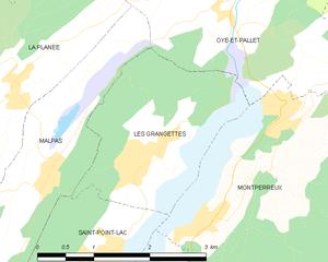
Les Grangettes
- commune in Doubs, France
Hiking in Les Grangettes
Les Grangettes is a beautiful hiking destination located in the French Alps, close to the town of Échirolles and the larger city of Grenoble. The area is known for its stunning natural scenery, characterized by lush meadows, alpine forests, and breathtaking mountain views....
- Country:
- Postal Code: 25160
- Coordinates: 46° 49' 40" N, 6° 18' 40" E
- GPS tracks (wikiloc): [Link]
- Area: 5.38 sq km
- Population: 276