Montpeyroux (Montpeyroux)

- commune in Hérault, France
- Country:

- Postal Code: 34150
- Coordinates: 43° 41' 43" N, 3° 30' 23" E


- GPS tracks (wikiloc): [Link]
- Area: 22.42 sq km
- Population: 1327
- Web site: http://www.montpeyroux34.fr
- Wikipedia en: wiki(en)
- Wikipedia: wiki(fr)
- Wikidata storage: Wikidata: Q670028
- Wikipedia Commons Gallery: [Link]
- Wikipedia Commons Category: [Link]
- Freebase ID: [/m/03nw48x]
- Freebase ID: [/m/03nw48x]
- GeoNames ID: Alt: [6432562]
- GeoNames ID: Alt: [6432562]
- SIREN number: [213401730]
- SIREN number: [213401730]
- BnF ID: [152567745]
- BnF ID: [152567745]
- INSEE municipality code: 34173
- INSEE municipality code: 34173
Shares border with regions:


Arboras
- commune in Hérault, France
- Country:
- Postal Code: 34150
- Coordinates: 43° 42' 39" N, 3° 29' 5" E
- GPS tracks (wikiloc): [Link]
- Area: 6.73 sq km
- Population: 120

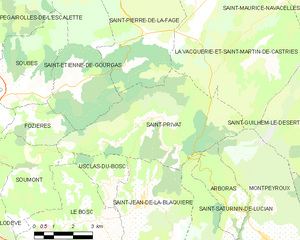
Saint-Privat
- commune in Hérault, France
- Country:
- Postal Code: 34700
- Coordinates: 43° 45' 17" N, 3° 26' 10" E
- GPS tracks (wikiloc): [Link]
- Area: 26.9 sq km
- Population: 412


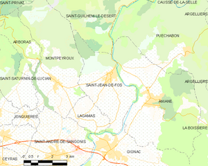
Lagamas
- commune in Hérault, France
- Country:
- Postal Code: 34150
- Coordinates: 43° 40' 26" N, 3° 31' 23" E
- GPS tracks (wikiloc): [Link]
- Area: 4.52 sq km
- Population: 110


Saint-Saturnin-de-Lucian
- commune in Hérault, France
- Country:
- Postal Code: 34725
- Coordinates: 43° 41' 39" N, 3° 28' 15" E
- GPS tracks (wikiloc): [Link]
- AboveSeaLevel: 150 м m
- Area: 9.83 sq km
- Population: 298


Saint-Guilhem-le-Désert
- commune in Hérault, France
- Country:
- Postal Code: 34150
- Coordinates: 43° 44' 2" N, 3° 32' 59" E
- GPS tracks (wikiloc): [Link]
- Area: 38.64 sq km
- Population: 257
- Web site: [Link]

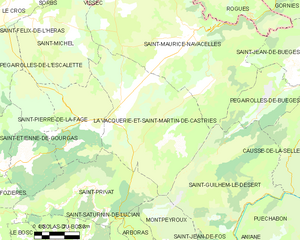
La Vacquerie-et-Saint-Martin-de-Castries
- commune in Hérault, France
- Country:
- Postal Code: 34520
- Coordinates: 43° 47' 21" N, 3° 27' 38" E
- GPS tracks (wikiloc): [Link]
- Area: 43.05 sq km
- Population: 182
- Web site: [Link]

Saint-André-de-Sangonis
- commune in Hérault, France
- Country:
- Postal Code: 34725
- Coordinates: 43° 38' 59" N, 3° 30' 13" E
- GPS tracks (wikiloc): [Link]
- Area: 19.6 sq km
- Population: 5678
- Web site: [Link]

Saint-Jean-de-Fos
- commune in Hérault, France
- Country:
- Postal Code: 34150
- Coordinates: 43° 42' 3" N, 3° 33' 3" E
- GPS tracks (wikiloc): [Link]
- Area: 14.19 sq km
- Population: 1648