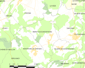
Montrond-le-Château (Montrond-le-Château)

- commune in Doubs, France
 Hiking in Montrond-le-Château
Montrond-le-Château, located in the Bourgogne-Franche-Comté region of eastern France, offers a charming and picturesque setting for hiking enthusiasts. The area is characterized by its rolling hills, lush forests, and beautiful landscapes, making it a great destination for those looking to explore nature.
Trails and Routes:
-
Local Trails: There are a variety of hiking trails suitable for different skill levels. Some paths are well-marked and easy to follow, while others may present more of a challenge with rough terrain.
-
Iconic Landscapes: Hikes around Montrond-le-Château often offer stunning views of the surrounding countryside, including vineyards, farmlands, and distant hills, particularly in the fall when foliage transforms into vibrant colors.
-
Historical Sites: Some trails might lead you to nearby historical sites, like old churches or châteaux, providing an enriching experience that combines nature and culture.
-
Shorter Walks: If you’re looking for a more relaxed outing, there are shorter walking routes around the village that allow you to take in the local sights without a strenuous hike.
Tips for Hiking in Montrond-le-Château:
-
Seasonal Considerations: Check the weather and trail conditions before setting out. Spring and early autumn generally offer the best hiking conditions, with milder temperatures and beautiful scenery.
-
Gear: Wear appropriate hiking footwear, and bring sufficient water and snacks, especially if you plan to hike longer routes.
-
Wildlife: Be mindful of local wildlife; you might encounter deer, birds, and various plant species. It’s a great opportunity for nature photography!
-
Maps and Information: Consider grabbing a local hiking map or using a hiking app to navigate the trails. Local tourism offices can provide helpful information about the best routes and conditions.
-
Respect Nature: Always follow Leave No Trace principles to preserve the natural beauty of the area. Pack out any trash and stay on designated trails.
Hiking in Montrond-le-Château can be a rewarding experience, offering a blend of outdoor adventure and cultural exploration. Whether you're a seasoned hiker or a casual walker, there's something for everyone in this beautiful region.
- Country:

- Postal Code: 25660
- Coordinates: 47° 8' 37" N, 6° 2' 46" E


- GPS tracks (wikiloc): [Link]
- Area: 10.9 sq km
- Population: 560
- Web site: http://www.montrond-le-chateau.fr
- Wikipedia en: wiki(en)
- Wikipedia: wiki(fr)
- Wikidata storage: Wikidata: Q665273
- Wikipedia Commons Category: [Link]
- Freebase ID: [/m/03mgy1f]
- Freebase ID: [/m/03mgy1f]
- GeoNames ID: Alt: [6429902]
- GeoNames ID: Alt: [6429902]
- SIREN number: [212504062]
- SIREN number: [212504062]
- BnF ID: [152526320]
- BnF ID: [152526320]
- INSEE municipality code: 25406
- INSEE municipality code: 25406
Shares border with regions:


Épeugney
- commune in Doubs, France
Hiking in Épeugney
Épeugney is a picturesque village in the Haute-Saône department in the Bourgogne-Franche-Comté region of eastern France. The surrounding landscape is characterized by rolling hills, forests, and meadows, offering a serene backdrop for hiking enthusiasts. Here's what you can expect when hiking in and around Épeugney:...
- Country:
- Postal Code: 25290
- Coordinates: 47° 7' 3" N, 6° 1' 28" E
- GPS tracks (wikiloc): [Link]
- Area: 13.95 sq km
- Population: 603

Mérey-sous-Montrond
- commune in Doubs, France
Hiking in Mérey-sous-Montrond
Mérey-sous-Montrond is a charming commune located in the Doubs department in the Bourgogne-Franche-Comté region of eastern France. The area surrounding Mérey-sous-Montrond offers various opportunities for hiking enthusiasts to explore the beautiful landscapes, forests, and countryside typical of this region....
- Country:
- Postal Code: 25660
- Coordinates: 47° 9' 5" N, 6° 4' 7" E
- GPS tracks (wikiloc): [Link]
- Area: 10.79 sq km
- Population: 419


Villers-sous-Montrond
- commune in Doubs, France
Hiking in Villers-sous-Montrond
Villers-sous-Montrond, located in the Doubs department of eastern France, offers a scenic environment that is ideal for hiking. The region is characterized by its rolling hills, forests, and rivers, making it a great spot for outdoor activities....
- Country:
- Postal Code: 25620
- Coordinates: 47° 8' 42" N, 6° 5' 19" E
- GPS tracks (wikiloc): [Link]
- Area: 6.33 sq km
- Population: 210


Arguel
- commune in Doubs, France
Hiking in Arguel
Arguel, located in the Doubs department of France, is a beautiful area that offers a variety of hiking opportunities amidst picturesque landscapes. The region is characterized by rolling hills, lush forests, and scenic views, making it a wonderful destination for nature lovers and hiking enthusiasts alike....
- Country:
- Postal Code: 25720
- Coordinates: 47° 11' 51" N, 6° 0' 7" E
- GPS tracks (wikiloc): [Link]
- Area: 4.98 sq km
- Population: 274


Scey-Maisières
- commune in Doubs, France
Hiking in Scey-Maisières
Scey-Maisières is a charming commune located in the Doubs department of the Bourgogne-Franche-Comté region in eastern France. It is surrounded by picturesque landscapes, making it a delightful destination for hiking enthusiasts. Here are some key points about hiking in the area:...
- Country:
- Postal Code: 25290
- Coordinates: 47° 6' 2" N, 6° 4' 32" E
- GPS tracks (wikiloc): [Link]
- AboveSeaLevel: 362 м m
- Area: 12.53 sq km
- Population: 295


Malbrans
- commune in Doubs, France
Hiking in Malbrans
Malbrans, also known as Malbrans Gorges, is a stunning location that offers a variety of hiking opportunities. When hiking in this area, you can expect beautiful landscapes, lush vegetation, and possibly the chance to see unique wildlife. Here are a few key points about hiking in Malbrans:...
- Country:
- Postal Code: 25620
- Coordinates: 47° 7' 13" N, 6° 4' 53" E
- GPS tracks (wikiloc): [Link]
- Area: 8.74 sq km
- Population: 144


Pugey
- commune in Doubs, France
Hiking in Pugey
Pugey, located in the Doubs department of France, is a picturesque area that offers a variety of hiking opportunities amidst beautiful natural landscapes. The region is characterized by rolling hills, lush forests, and striking geological formations, making it an ideal destination for both novice and experienced hikers....
- Country:
- Postal Code: 25720
- Coordinates: 47° 11' 5" N, 5° 59' 26" E
- GPS tracks (wikiloc): [Link]
- Area: 7.32 sq km
- Population: 759

Fontain
- commune in Doubs, France
Hiking in Fontain
Fontain, located near the French city of Grenoble in the Auvergne-Rhône-Alpes region, offers a variety of hiking opportunities that cater to different skill levels and interests. The area is characterized by stunning natural landscapes, including mountains, forests, and picturesque views of the surrounding valleys....
- Country:
- Postal Code: 25660
- Coordinates: 47° 11' 55" N, 6° 1' 34" E
- GPS tracks (wikiloc): [Link]
- Area: 16.27 sq km
- Population: 1009
- Web site: [Link]