Moosbach (Moosbach)
- municipality in Austria
 Hiking in Moosbach
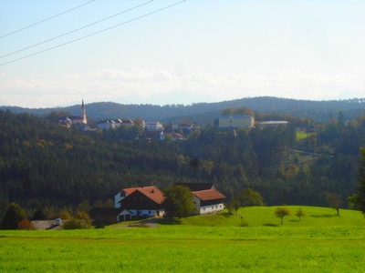
Moosbach, a picturesque area in Austria, is surrounded by beautiful natural landscapes, making it an excellent destination for hiking enthusiasts. Nestled in the Upper Austria region, near the border with Bavaria, Moosbach offers a variety of trails catering to different skill levels, from easy walks to challenging hikes.
Hiking Opportunities:
-
Scenic Trails: There are numerous well-marked trails that allow hikers to explore the lush forests, rolling hills, and stunning viewpoints of the surrounding countryside. The trails often offer panoramic views of the Alps.
-
Flora and Fauna: As you hike, you may encounter diverse plant species and wildlife, including deer, foxes, and various bird species. Spring and summer are particularly vibrant, with wildflowers blooming along the trails.
-
Cultural Sites: Some trails may lead you to historical sites, quaint villages, or local farms, providing an opportunity to experience Austrian culture and hospitality.
-
Difficulty Levels: Whether you are a beginner looking for a leisurely hike or an experienced hiker seeking a more strenuous challenge, you'll find suitable routes. Always check trail difficulty ratings and prepare accordingly.
Tips for Hiking in Moosbach:
- Check the Weather: Always check the weather forecast before heading out, as conditions can change quickly in mountainous areas.
- Gear Up: Wear appropriate hiking footwear and clothing. Sturdy shoes and weather-appropriate attire are essential.
- Stay Hydrated: Bring plenty of water and some snacks to keep your energy up during your hike.
- Navigation: While many trails are well marked, it’s a good idea to carry a map or downloadable trail app.
Nearby Attractions:
- Local Attractions: After hiking, you can explore nearby towns or relax in a local café to enjoy traditional Austrian cuisine.
- Public Transport: If you're traveling without a car, check local transport options to access trailheads more easily.
Moosbach is a charming hiking destination perfect for enjoying the serene beauty of Austria’s natural landscape. Make sure to plan your hike and enjoy the adventure!
- Country:

- Local Dialing Code: 07724
- Licence Plate Code: BR
- Coordinates: 48° 12' 20" N, 13° 9' 50" E


- GPS tracks (wikiloc): [Link]
- AboveSeaLevel: 403 м m
- Area: 19.1 sq km
- Population: 1042
- Web site: http://www.moosbach.at/
- Wikipedia en: wiki(en)
- Wikipedia: wiki(de)
- Wikidata storage: Wikidata: Q669217
- Wikipedia Commons Category: [Link]
- Freebase ID: [/m/03gv2gj]
- GeoNames ID: Alt: [7871978]
- VIAF ID: Alt: [241895413]
- Austrian municipality key: [40424]
Shares border with regions:
Treubach
- municipality in Austria
Hiking in Treubach
Treubach is likely a lesser-known location for hiking, as there isn't a widely recognized hiking destination by that name in popular hiking literature or resources. However, if you are referring to a specific region or a local area with that name, the details could vary significantly based on the local geography, trails, and natural features....
- Country:
- Local Dialing Code: 07724
- Licence Plate Code: BR
- Coordinates: 48° 11' 42" N, 13° 12' 47" E
- GPS tracks (wikiloc): [Link]
- AboveSeaLevel: 417 м m
- Area: 13.04 sq km
- Population: 725
- Web site: [Link]

Altheim
- municipality in Austria
Hiking in Altheim
Altheim, Austria, is a small but charming town located in the upper part of the country, nestled amidst beautiful landscapes that provide opportunities for various outdoor activities, including hiking. While Altheim itself might not be a major hiking destination, its surrounding areas offer numerous trails and routes suitable for hikers of all skill levels....
- Country:
- Postal Code: 4950
- Local Dialing Code: 07723
- Licence Plate Code: BR
- Coordinates: 48° 15' 0" N, 13° 14' 0" E
- GPS tracks (wikiloc): [Link]
- AboveSeaLevel: 363 м m
- Area: 22.63 sq km
- Population: 4839
- Web site: [Link]

Burgkirchen
- municipality in Austria
Hiking in Burgkirchen
Burgkirchen, located in Austria’s picturesque Upper Austria region, offers a variety of hiking opportunities that cater to different skill levels. The area is characterized by beautiful landscapes, including rolling hills, forests, and rivers, making it perfect for both casual walkers and more experienced hikers....
- Country:
- Local Dialing Code: 07724
- Licence Plate Code: BR
- Coordinates: 48° 12' 16" N, 13° 6' 5" E
- GPS tracks (wikiloc): [Link]
- AboveSeaLevel: 393 м m
- Area: 45.91 sq km
- Population: 2661
- Web site: [Link]
Maria Schmolln
- municipality in Austria
Hiking in Maria Schmolln
Maria Schmolln is a picturesque village located in the state of Upper Austria, known for its beautiful landscapes and great hiking opportunities. The region is characterized by rolling hills, dense forests, and meadows, making it a delightful destination for both seasoned hikers and those looking for a leisurely stroll in nature....
- Country:
- Postal Code: 5241
- Local Dialing Code: 07743
- Licence Plate Code: BR
- Coordinates: 48° 8' 0" N, 13° 13' 0" E
- GPS tracks (wikiloc): [Link]
- AboveSeaLevel: 557 м m
- Area: 34.5 sq km
- Population: 1414
- Web site: [Link]

Helpfau-Uttendorf
- municipality in Austria
Hiking in Helpfau-Uttendorf
Helpfau-Uttendorf is a picturesque village located in Austria, nestled in the Salzkammergut region. This area is known for its beautiful landscapes, rolling hills, and access to the majestic Alps, making it an excellent destination for hiking enthusiasts....
- Country:
- Postal Code: 5261
- Local Dialing Code: 07724
- Licence Plate Code: BR
- Coordinates: 48° 9' 20" N, 13° 7' 5" E
- GPS tracks (wikiloc): [Link]
- AboveSeaLevel: 419 м m
- Area: 26.38 sq km
- Population: 3573
- Web site: [Link]

Mauerkirchen
- municipality in Austria
Hiking in Mauerkirchen
Mauerkirchen, a small town in Austria located in the state of Upper Austria, offers various hiking opportunities that showcase the stunning natural landscape of the region. The surroundings are characterized by rolling hills, scenic countryside, and nearby forests that provide a peaceful atmosphere for outdoor enthusiasts....
- Country:
- Postal Code: 5270
- Local Dialing Code: 07724
- Licence Plate Code: BR
- Coordinates: 48° 11' 27" N, 13° 8' 7" E
- GPS tracks (wikiloc): [Link]
- AboveSeaLevel: 407 м m
- Area: 3.09 sq km
- Population: 2566
- Web site: [Link]

Weng im Innkreis
- municipality in Austria
Hiking in Weng im Innkreis
Weng im Innkreis, located in the Innviertel region of Upper Austria, is a charming area that offers opportunities for hiking enthusiasts. The surrounding landscapes feature beautiful rural scenery, rolling hills, and well-maintained trails, making it an ideal location for outdoor activities like hiking....
- Country:
- Local Dialing Code: 07723
- Licence Plate Code: BR
- Coordinates: 48° 14' 9" N, 13° 10' 47" E
- GPS tracks (wikiloc): [Link]
- AboveSeaLevel: 370 м m
- Area: 21.36 sq km
- Population: 1394
- Web site: [Link]