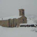
Moydans (Moydans)
- commune in Hautes-Alpes, France
 Hiking in Moydans
Moydans is not a widely recognized hiking destination, and it seems there might be a spelling error or it might refer to a specific, lesser-known location or a local site unfamiliar to broader audiences. If you meant a different location or if it's a local spot, let me know!
However, if you’re looking for general tips on hiking or if you meant a specific region, such as the Moydans region in a specific country or context, please provide more details so I can give you the most relevant information!
For now, here are some general hiking tips:
-
Research the Trail: Make sure to gather information about the trail length, difficulty level, and trail conditions.
-
Pack Essentials: Bring enough water, snacks, a first-aid kit, navigation tools (like a map and compass or GPS), and weather-appropriate clothing.
-
Stay Safe: Inform someone about your hiking plans, stay on marked trails, and be aware of wildlife in the area.
-
Leave No Trace: Respect nature; carry out what you bring in and avoid disturbing wildlife.
-
Know Your Limits: Choose trails that suit your fitness level and experience. Always listen to your body and turn back if necessary.
If you have a specific location, please provide more details!
- Country:

- Postal Code: 05150
- Coordinates: 44° 23' 59" N, 5° 30' 13" E


- GPS tracks (wikiloc): [Link]
- AboveSeaLevel: 633 м m
- Area: 10.51 sq km
- Population: 47
- Wikipedia en: wiki(en)
- Wikipedia: wiki(fr)
- Wikidata storage: Wikidata: Q1087615
- Wikipedia Commons Category: [Link]
- Freebase ID: [/m/03mfmmq]
- Freebase ID: [/m/03mfmmq]
- GeoNames ID: Alt: [6446665]
- GeoNames ID: Alt: [6446665]
- SIREN number: [210500914]
- SIREN number: [210500914]
- INSEE municipality code: 05091
- INSEE municipality code: 05091
Shares border with regions:

Rosans
- commune in Hautes-Alpes, France
Hiking in Rosans
Rosans is a charming village located in the Hautes-Alpes region of southeastern France, known for its picturesque landscapes, diverse flora, and a range of hiking opportunities. Here are some key points about hiking in and around Rosans:...
- Country:
- Postal Code: 05150
- Coordinates: 44° 23' 30" N, 5° 28' 12" E
- GPS tracks (wikiloc): [Link]
- Area: 30.39 sq km
- Population: 492
- Web site: [Link]

Ribeyret
- commune in Hautes-Alpes, France
Hiking in Ribeyret
Ribeyret is a picturesque village located in the Hautes-Alpes department of the Provence-Alpes-Côte d'Azur region in southeastern France. The area around Ribeyret is known for its stunning landscapes, diverse flora and fauna, and great opportunities for hiking and outdoor activities....
- Country:
- Postal Code: 05150
- Coordinates: 44° 24' 48" N, 5° 33' 17" E
- GPS tracks (wikiloc): [Link]
- Area: 17.87 sq km
- Population: 105

Saint-André-de-Rosans
- commune in Hautes-Alpes, France
Hiking in Saint-André-de-Rosans
Saint-André-de-Rosans is a charming village located in the Hautes-Alpes region of southeastern France. It's a fantastic area for hikers, offering a variety of trails that cater to different skill levels and preferences. Here are some highlights about hiking in this picturesque location:...
- Country:
- Postal Code: 05150
- Coordinates: 44° 22' 38" N, 5° 30' 52" E
- GPS tracks (wikiloc): [Link]
- Area: 36.61 sq km
- Population: 145
Montmorin
- former commune in Hautes-Alpes, France
Hiking in Montmorin
Montmorin, located in the Hautes-Alpes region of France, is a stunning area for outdoor enthusiasts, particularly hikers. The region offers a variety of trails suitable for all skill levels, ranging from easy walks to more challenging hikes that reward adventurers with breathtaking views of the mountains and surrounding landscapes....
- Country:
- Postal Code: 05150
- Coordinates: 44° 27' 5" N, 5° 32' 32" E
- GPS tracks (wikiloc): [Link]
- Area: 25.86 sq km
- Population: 90

Bruis
- former commune in Hautes-Alpes, France
Hiking in Bruis
Bruis, a charming village in France's Hautes-Alpes region, offers a range of beautiful hiking opportunities that take advantage of the stunning Alpine scenery. Here are some key points to consider when hiking in and around Bruis:...
- Country:
- Postal Code: 05150
- Coordinates: 44° 28' 5" N, 5° 30' 49" E
- GPS tracks (wikiloc): [Link]
- Area: 25.15 sq km
- Population: 77


Pommerol
- commune in Drôme, France
Hiking in Pommerol
Pommerol, located in the heart of the French Alps, is a charming destination for hiking enthusiasts. The region is known for its stunning landscapes, diverse terrains, and picturesque villages. Here are some highlights and tips for hiking in Pommerol:...
- Country:
- Postal Code: 26470
- Coordinates: 44° 26' 46" N, 5° 27' 8" E
- GPS tracks (wikiloc): [Link]
- AboveSeaLevel: 890 м m
- Area: 9.83 sq km
- Population: 20