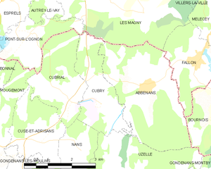
Nans (Nans)

- commune in Doubs, France
 Hiking in Nans
Nans, located in the Doubs department of France, is a beautiful area for hiking, surrounded by the stunning landscapes of the Jura Mountains. The region offers a mix of rugged terrain, lush forests, picturesque villages, and varied wildlife, making it a great destination for both experienced hikers and families looking for a peaceful outing.
Hiking Trails:
-
Les Gorges de la Loue: A popular hiking route that offers breathtaking views of the Loue River. The trail takes you through dramatic limestone gorges and lush greenery, with opportunities to spot wildlife.
-
Château de Gilley: A moderate hike that leads you to the ruins of this historic castle, offering panoramic views of the surrounding countryside. The trail is relatively easy and great for families.
-
Le Saut de Doubs: A bit further from Nans but worth the trip, this is a stunning waterfall you can hike to. The route features beautiful vistas along the way and is a popular spot for photographers.
Hiking Tips:
- Trail Maps: Always carry a detailed map or use a hiking app for navigation, as some trails can be less marked.
- Best Times: The best time for hiking in this region is spring (March to June) and fall (September to November) when the weather is mild, and the scenery is particularly beautiful.
- Gear: Wear sturdy hiking boots and dress in layers, as the temperature can change quickly.
- Safety: Always inform someone about your hiking plans and estimated return time, especially if you’re hiking alone or on remote trails.
Local Attractions:
- Natural Landscapes: The area is known for its breathtaking natural beauty, including the Doubs River and various natural parks.
- Culture: Explore the local culture by visiting charming villages and tasting regional specialties like Comté cheese.
Overall, Nans, Doubs is a fantastic destination for any hiking enthusiast, offering a combination of scenic beauty, adventure, and cultural experiences.
- Country:

- Postal Code: 25680
- Coordinates: 47° 28' 36" N, 6° 24' 42" E


- GPS tracks (wikiloc): [Link]
- Area: 3.2 sq km
- Population: 102
- Wikipedia en: wiki(en)
- Wikipedia: wiki(fr)
- Wikidata storage: Wikidata: Q906224
- Wikipedia Commons Category: [Link]
- Freebase ID: [/m/03nmkp4]
- Freebase ID: [/m/03nmkp4]
- GeoNames ID: Alt: [6453859]
- GeoNames ID: Alt: [6453859]
- SIREN number: [212504195]
- SIREN number: [212504195]
- BnF ID: [15252645b]
- BnF ID: [15252645b]
- INSEE municipality code: 25419
- INSEE municipality code: 25419
Shares border with regions:

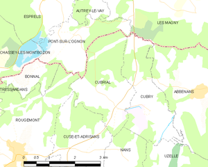
Cubry
- commune in Doubs, France
Hiking in Cubry
It seems that there might be a typographical error or a misunderstanding regarding "Cubry." If you're referring to a specific region, national park, or local hiking area, please provide more details or clarify the name, and I'd be glad to assist you....
- Country:
- Postal Code: 25680
- Coordinates: 47° 29' 36" N, 6° 25' 21" E
- GPS tracks (wikiloc): [Link]
- Area: 5.4 sq km
- Population: 85


Uzelle
- commune in Doubs, France
Hiking in Uzelle
Uzelle is a picturesque destination well-suited for hiking enthusiasts. Nestled in a natural environment that often boasts serene landscapes and diverse ecosystems, it presents various trails that cater to different skill levels. Here are some highlights to consider when hiking in Uzelle:...
- Country:
- Postal Code: 25340
- Coordinates: 47° 27' 58" N, 6° 26' 10" E
- GPS tracks (wikiloc): [Link]
- Area: 11.75 sq km
- Population: 171

Cuse-et-Adrisans
- commune in Doubs, France
Hiking in Cuse-et-Adrisans
Cuse-et-Adrisans is a charming commune located in the Haute-Saône department in the Bourgogne-Franche-Comté region of eastern France. While it may not be as well-known as some of the larger tourist destinations, it offers beautiful landscapes and a tranquil environment for hiking enthusiasts....
- Country:
- Postal Code: 25680
- Coordinates: 47° 28' 46" N, 6° 23' 27" E
- GPS tracks (wikiloc): [Link]
- Area: 5.42 sq km
- Population: 286
Cubrial
- commune in Doubs, France
Hiking in Cubrial
It seems that "Cubrial" is not a commonly recognized hiking destination or location within my training data up to October 2023. However, I'm here to help you with hiking in a variety of locations!...
- Country:
- Postal Code: 25680
- Coordinates: 47° 29' 45" N, 6° 24' 25" E
- GPS tracks (wikiloc): [Link]
- Area: 5.92 sq km
- Population: 131


Fontenelle-Montby
- commune in Doubs, France
Hiking in Fontenelle-Montby
Fontenelle-Montby is a beautiful area ideal for hiking enthusiasts, situated in the Jura Mountains of France. This region offers a range of scenic trails that cater to various skill levels, featuring lush forests, stunning vistas, and unique geological formations....
- Country:
- Postal Code: 25340
- Coordinates: 47° 26' 58" N, 6° 24' 51" E
- GPS tracks (wikiloc): [Link]
- Area: 6.65 sq km
- Population: 94