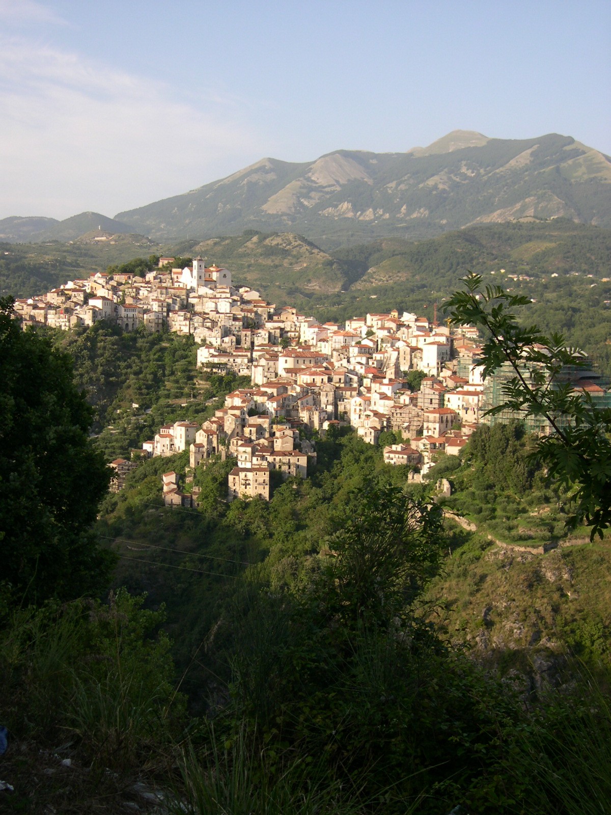
Nemoli (Nemoli)
.svg)
- Italian comune
 Hiking in Nemoli
Nemoli, located in the Basilicata region of Southern Italy, is a hidden gem for hiking enthusiasts. Nestled in the scenic landscape of the Pollino National Park, it offers stunning natural beauty, diverse wildlife, and a range of hiking trails suitable for various skill levels.
Hiking Trails in Nemoli
-
Pollino National Park Trails: The park features numerous trails, some leading to breathtaking viewpoints, waterfalls, and ancient forests. Popular routes include those around Mount Pollino, the highest peak in the southern Apennines.
-
Sentiero del Lupo (Wolf Trail): This trail provides a chance to explore the local ecosystem. As you hike, keep an eye out for wildlife, including the elusive Apennine wolf.
-
Scalise Path: Another scenic option that offers stunning views of the surrounding mountains and valleys. It’s an excellent choice for those looking to experience the natural beauty at a moderate hiking pace.
-
Cascate del Lupo: For those who enjoy waterfalls, consider a hike to the Wolf Waterfalls. The route can be challenging but rewards hikers with beautiful views of cascading water.
Best Time to Visit
- Spring (March to June): Ideal for hiking due to mild temperatures and blooming wildflowers.
- Autumn (September to November): Offers stunning fall foliage and pleasant hiking conditions.
Tips for Hikers
- Preparation: Always check local weather conditions and trail maps. Ensure you have suitable gear, including sturdy hiking boots, water, and snacks.
- Wildlife Awareness: Be aware of local wildlife, and practice leave-no-trace principles to protect the natural environment.
- Local Guides: Consider hiring a local guide for an enhanced experience. They can provide insights into the flora, fauna, and history of the area.
Cultural Experience
While hiking in Nemoli, take some time to explore the quaint town itself. Enjoy traditional Basilicata cuisine and local hospitality, which can enhance your hiking experience with a taste of the region’s culture.
Overall, hiking in Nemoli promises a combination of natural beauty, adventure, and cultural enrichment, making it a worthwhile destination for outdoor enthusiasts.
- Country:

- Postal Code: 85040
- Local Dialing Code: 0973
- Licence Plate Code: PZ
- Coordinates: 40° 4' 0" N, 15° 48' 0" E


- GPS tracks (wikiloc): [Link]
- AboveSeaLevel: 421 м m
- Area: 19.49 sq km
- Population: 1471
- Web site: http://www.comune.nemoli.pz.it/
- Wikipedia en: wiki(en)
- Wikipedia: wiki(it)
- Wikidata storage: Wikidata: Q52623
- Wikipedia Commons Category: [Link]
- Freebase ID: [/m/0fh3l_]
- GeoNames ID: Alt: [6539005]
- OSM relation ID: [40232]
- ISTAT ID: 076054
- Italian cadastre code: F866
Shares border with regions:
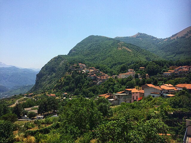
Lagonegro
- Italian comune
Hiking in Lagonegro
Lagonegro is a beautiful town located in the southern Italian region of Basilicata, surrounded by stunning natural landscapes, mountains, and the Pollino National Park. Hiking in Lagonegro offers a variety of trails that cater to different experience levels, making it a fantastic destination for nature lovers and outdoor enthusiasts....
- Country:
- Postal Code: 85042
- Local Dialing Code: 0973
- Licence Plate Code: PZ
- Coordinates: 40° 8' 0" N, 15° 46' 0" E
- GPS tracks (wikiloc): [Link]
- AboveSeaLevel: 666 м m
- Area: 113.07 sq km
- Population: 5442
- Web site: [Link]


Lauria
- Italian comune
Hiking in Lauria
Lauria is a beautiful location in the Basilicata region of southern Italy, known for its stunning landscapes, rich history, and outdoor activities, including hiking. The area offers a variety of trails suitable for different skill levels, from easy walks to more challenging hikes, all set against the backdrop of the Apennine mountains....
- Country:
- Postal Code: 85044
- Local Dialing Code: 0973
- Licence Plate Code: PZ
- Coordinates: 40° 2' 50" N, 15° 50' 9" E
- GPS tracks (wikiloc): [Link]
- AboveSeaLevel: 430 м m
- Area: 176.63 sq km
- Population: 12694
- Web site: [Link]

Rivello
- Italian comune
Hiking in Rivello
Rivello is a picturesque village located in the Basilicata region of southern Italy, known for its stunning landscapes and charming architecture. The area around Rivello offers various hiking opportunities that cater to different skill levels, appealing to both experienced hikers and those looking for leisurely walks....
- Country:
- Postal Code: 85040
- Local Dialing Code: 0973
- Licence Plate Code: PZ
- Coordinates: 40° 4' 42" N, 15° 45' 29" E
- GPS tracks (wikiloc): [Link]
- AboveSeaLevel: 479 м m
- Area: 69.58 sq km
- Population: 2731
- Web site: [Link]

Trecchina
- Italian comune
Hiking in Trecchina
Trecchina is a charming town located in the Basilicata region of southern Italy, surrounded by stunning natural landscapes that are ideal for hiking and outdoor activities. Here are some highlights and tips for hiking in and around Trecchina:...
- Country:
- Postal Code: 85049
- Local Dialing Code: 0973
- Licence Plate Code: PZ
- Coordinates: 40° 2' 0" N, 15° 46' 0" E
- GPS tracks (wikiloc): [Link]
- AboveSeaLevel: 500 м m
- Area: 38.19 sq km
- Population: 2297
- Web site: [Link]