Nieuil (Nieuil)

- commune in Charente, France
- Country:

- Postal Code: 16270
- Coordinates: 45° 52' 43" N, 0° 30' 5" E


- GPS tracks (wikiloc): [Link]
- Area: 23.9 sq km
- Population: 929
- Wikipedia en: wiki(en)
- Wikipedia: wiki(fr)
- Wikidata storage: Wikidata: Q948655
- Wikipedia Commons Category: [Link]
- Freebase ID: [/m/03mcch2]
- GeoNames ID: Alt: [2990387]
- SIREN number: [211602453]
- BnF ID: [15248684g]
- INSEE municipality code: 16245
Shares border with regions:


Genouillac
- commune in Charente, France
- Country:
- Postal Code: 16270
- Coordinates: 45° 51' 10" N, 0° 34' 16" E
- GPS tracks (wikiloc): [Link]
- Area: 14.59 sq km
- Population: 605

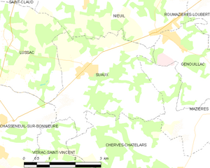
Suaux
- commune in Charente, France
- Country:
- Postal Code: 16260
- Coordinates: 45° 51' 6" N, 0° 30' 23" E
- GPS tracks (wikiloc): [Link]
- Area: 11.93 sq km
- Population: 412
- Web site: [Link]

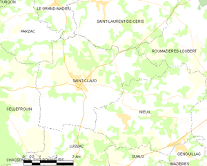
Saint-Claud
- commune in Charente, France
- Country:
- Postal Code: 16450
- Coordinates: 45° 53' 43" N, 0° 27' 54" E
- GPS tracks (wikiloc): [Link]
- Area: 26.75 sq km
- Population: 1074


Lussac
- commune in Charente, France
- Country:
- Postal Code: 16450
- Coordinates: 45° 51' 39" N, 0° 27' 48" E
- GPS tracks (wikiloc): [Link]
- AboveSeaLevel: 155 м m
- Area: 11.7 sq km
- Population: 292
- Web site: [Link]


Roumazières-Loubert
- commune in Charente, France
- Country:
- Postal Code: 16270
- Coordinates: 45° 53' 42" N, 0° 34' 31" E
- GPS tracks (wikiloc): [Link]
- Area: 46.59 sq km
- Population: 2494
- Web site: [Link]