Nointel (Nointel)

- commune in Oise, France
- Country:

- Postal Code: 60840
- Coordinates: 49° 22' 29" N, 2° 28' 55" E


- GPS tracks (wikiloc): [Link]
- Area: 9.35 sq km
- Population: 1001
- Web site: http://www.commune-nointel.fr
- Wikipedia en: wiki(en)
- Wikipedia: wiki(fr)
- Wikidata storage: Wikidata: Q1602890
- Wikipedia Commons Category: [Link]
- Freebase ID: [/m/03qgnk9]
- GeoNames ID: Alt: [6438866]
- SIREN number: [216004598]
- BnF ID: [152677002]
- INSEE municipality code: 60464
Shares border with regions:


Maimbeville
- commune in Oise, France
- Country:
- Postal Code: 60600
- Coordinates: 49° 24' 56" N, 2° 31' 15" E
- GPS tracks (wikiloc): [Link]
- Area: 5.75 sq km
- Population: 419
- Web site: [Link]

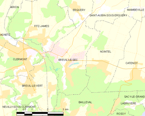
Breuil-le-Sec
- commune in Oise, France
- Country:
- Postal Code: 60600
- Coordinates: 49° 22' 13" N, 2° 27' 8" E
- GPS tracks (wikiloc): [Link]
- Area: 8.89 sq km
- Population: 2582
- Web site: [Link]

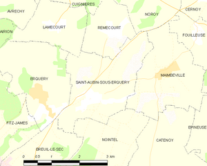
Saint-Aubin-sous-Erquery
- commune in Oise, France
- Country:
- Postal Code: 60600
- Coordinates: 49° 24' 27" N, 2° 29' 2" E
- GPS tracks (wikiloc): [Link]
- Area: 6.26 sq km
- Population: 332
- Web site: [Link]


Bailleval
- commune in Oise, France
- Country:
- Postal Code: 60140
- Coordinates: 49° 20' 52" N, 2° 27' 27" E
- GPS tracks (wikiloc): [Link]
- Area: 8.01 sq km
- Population: 1494
- Web site: [Link]

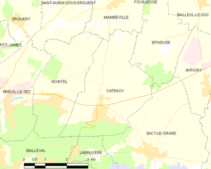
Catenoy
- commune in Oise, France
- Country:
- Postal Code: 60600
- Coordinates: 49° 22' 7" N, 2° 30' 39" E
- GPS tracks (wikiloc): [Link]
- Area: 12.61 sq km
- Population: 1049
- Web site: [Link]