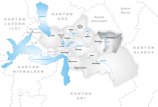
Oberiberg (Oberiberg)

- municipality in Switzerland
 Hiking in Oberiberg
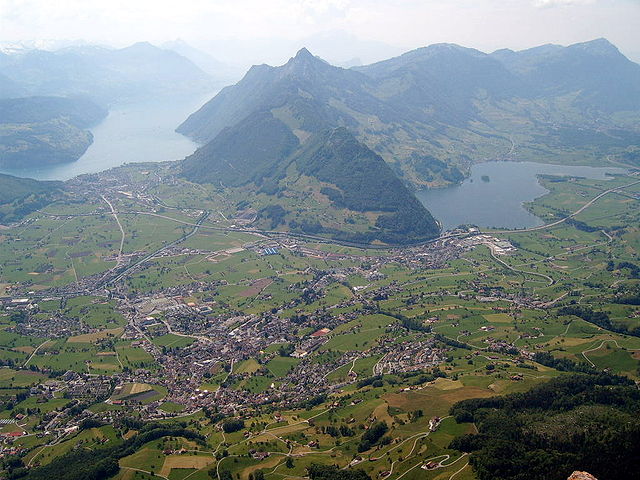
Oberiberg is a beautiful village located in Switzerland, nestled in the Ybrig region of central Switzerland. It's surrounded by stunning mountain landscapes, making it a fantastic destination for hiking enthusiasts of all levels. Here are some highlights and tips for hiking in Oberiberg:
Hiking Trails
-
Family-Friendly Trails: Oberiberg offers various trails suitable for families with children. Many of these paths are relatively flat and easy to navigate, making them perfect for a leisurely hike with younger hikers.
-
Mountain Trails: For those seeking more challenging hikes, the area boasts numerous mountain trails that take you to breathtaking viewpoints. One popular hike is the trail leading to the top of the Säntis, which offers panoramic vistas of the surrounding mountains and valleys.
-
Theme Trails: There are also themed hiking trails, such as nature trails that provide educational information about local flora and fauna. These trails can make for a more engaging experience, especially for families and groups.
Scenic Highlights
- Lakes: The area is home to beautiful alpine lakes, like the Egli Lake, which is a great spot for a rest or picnic during your hike.
- Views: Many trails offer stunning views of the Swiss Alps, valleys, and friendly farms dotting the hillside.
- Flora and Fauna: Depending on the season, you can witness diverse plant life and may even encounter local wildlife.
Preparing for Your Hike
- Weather: The weather in the Swiss mountains can change quickly, so check forecasts, dress in layers, and pack rain gear if necessary.
- Maps and Navigation: It's advisable to have a good map or GPS, as some trails may not be well-marked.
- Hydration and Snacks: Carry plenty of water and snacks, especially for longer hikes.
- Footwear: Wear sturdy hiking boots for comfort and stability, especially on rocky or uneven terrain.
Accessibility
Oberiberg is well-connected by public transport, and many trails can be accessed directly from the village. Depending on your location, there are also buses or cogwheel trains that can transport you closer to popular hiking starting points.
Conclusion
Whether you're an experienced hiker or just starting, Oberiberg offers a range of beautiful and enjoyable hiking experiences. Just remember to respect nature, stay on marked paths, and enjoy the breathtaking scenery that this beautiful region of Switzerland has to offer!
- Country:

- Postal Code: 8843
- Local Dialing Code: 055
- Licence Plate Code: SZ
- Coordinates: 47° 1' 49" N, 8° 46' 55" E


- GPS tracks (wikiloc): [Link]
- AboveSeaLevel: 1283 м m
- Area: 32.90 sq km
- Population: 888
- Web site: http://www.oberiberg.ch
- Wikipedia en: wiki(en)
- Wikipedia: wiki(de)
- Wikidata storage: Wikidata: Q66552
- Wikipedia Commons Category: [Link]
- Freebase ID: [/m/05rdmm]
- GeoNames ID: Alt: [7286699]
- VIAF ID: Alt: [237475004]
- OSM relation ID: [1683094]
- HDS ID: [732]
- Swiss municipality code: [1368]
Shares border with regions:

Unteriberg
- municipality in Switzerland
Hiking in Unteriberg
Unteriberg, located in the beautiful region of Switzerland, offers a variety of hiking opportunities that cater to different skill levels and preferences. Nestled in the Swiss Alps, it provides stunning views, lush landscapes, and an enjoyable outdoor experience....
- Country:
- Postal Code: 8842
- Local Dialing Code: 055
- Licence Plate Code: SZ
- Coordinates: 47° 2' 53" N, 8° 49' 53" E
- GPS tracks (wikiloc): [Link]
- AboveSeaLevel: 1469 м m
- Area: 46.7 sq km
- Population: 2413
- Web site: [Link]


Illgau
- municipality in Switzerland
Hiking in Illgau
Illgau is a picturesque village located in the canton of Schwyz in Switzerland. It's nestled on a sun-drenched terrace above the Muotatal valley, providing stunning views of the surrounding mountains and landscapes. Hiking in Illgau offers a varied experience, suitable for a range of skill levels, from easy family-friendly walks to more challenging mountain trails....
- Country:
- Postal Code: 6434
- Local Dialing Code: 041
- Licence Plate Code: SZ
- Coordinates: 46° 59' 48" N, 8° 44' 24" E
- GPS tracks (wikiloc): [Link]
- AboveSeaLevel: 1128 м m
- Area: 10.9 sq km
- Population: 797
- Web site: [Link]


Muotathal
- municipality in Switzerland
Hiking in Muotathal
Muotathal, located in the heart of Switzerland, offers stunning landscapes and diverse hiking opportunities, making it a fantastic destination for both novice and experienced hikers. Here are some highlights and tips for hiking in this beautiful region:...
- Country:
- Postal Code: 6436
- Local Dialing Code: 041
- Licence Plate Code: SZ
- Coordinates: 46° 58' 28" N, 8° 45' 28" E
- GPS tracks (wikiloc): [Link]
- AboveSeaLevel: 610 м m
- Area: 172.15 sq km
- Population: 3515
- Web site: [Link]


Alpthal
- municipality in Switzerland
Hiking in Alpthal
Alpthal, located in the picturesque Canton of Schwyz in Switzerland, is a fantastic destination for hiking enthusiasts. Nestled in the Alps, it offers stunning views, diverse trails, and the opportunity to experience the natural beauty of the Swiss landscape....
- Country:
- Postal Code: 8849
- Local Dialing Code: 055
- Licence Plate Code: SZ
- Coordinates: 47° 3' 28" N, 8° 42' 51" E
- GPS tracks (wikiloc): [Link]
- AboveSeaLevel: 1064 м m
- Area: 22.90 sq km
- Population: 613
- Web site: [Link]

Schwyz
- capital of the canton of Schwyz in Switzerland
Hiking in Schwyz
Hiking in Schwyz, located in central Switzerland, offers stunning landscapes, rich history, and a variety of trails catering to different skill levels. Here are some highlights and tips for hiking in this beautiful region:...
- Country:
- Postal Code: 6430
- Local Dialing Code: 041
- Licence Plate Code: SZ
- Coordinates: 47° 1' 14" N, 8° 39' 30" E
- GPS tracks (wikiloc): [Link]
- AboveSeaLevel: 852 м m
- Area: 53.28 sq km
- Population: 15000
- Web site: [Link]


Einsiedeln
- municipality in Switzerland
Hiking in Einsiedeln
Einsiedeln, located in the Canton of Schwyz in Switzerland, is a beautiful destination for hiking enthusiasts. Nestled in the picturesque alpine landscape, it offers a variety of trails suitable for all levels, from leisurely strolls to more challenging hikes....
- Country:
- Postal Code: 8840
- Local Dialing Code: 055
- Licence Plate Code: SZ
- Coordinates: 47° 7' 40" N, 8° 44' 35" E
- GPS tracks (wikiloc): [Link]
- AboveSeaLevel: 882 м m
- Area: 110.40 sq km
- Population: 15550
- Web site: [Link]