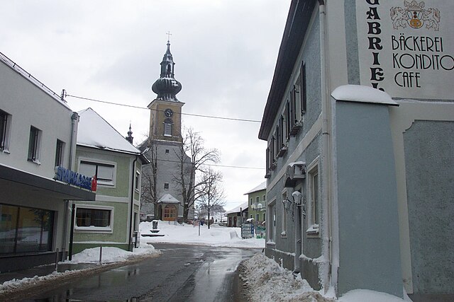
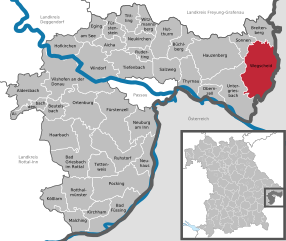
Oberkappel (Oberkappel)
- municipality in Austria
 Hiking in Oberkappel
Oberkappel is a picturesque village located in the Mühlviertel region of Upper Austria. Known for its stunning natural surroundings, Oberkappel is a great destination for hiking enthusiasts. Here are some highlights and tips for hiking in this area:
Trails and Routes
-
Local Trails: Oberkappel features several well-marked hiking trails, ranging from easy walks to more challenging hikes. The trails often lead through lush forests, rolling hills, and charming countryside, offering beautiful vistas and a chance to connect with nature.
-
Mühlviertel Region: Hiking in Oberkappel allows access to the broader Mühlviertel hiking network, which is known for its diverse landscapes, including hills, woods, streams, and traditional villages. This region offers many multi-day hiking routes as well.
-
The "Waldviertler Höhenweg": A long-distance trail that can be accessed near Oberkappel, this route provides a more immersive experience of the Mühlviertel’s unique natural beauty. It's perfect for experienced hikers looking for a challenge.
Flora and Fauna
- Biodiversity: The area boasts a rich variety of flora and fauna. You might encounter a range of wildflowers, dense forests, and perhaps even some local wildlife like deer or various bird species.
Best Time to Hike
- Season: The best time for hiking in Oberkappel is typically from late spring to early autumn (May to October), when weather conditions are generally favorable. However, summer can be quite warm, so early morning or late afternoon hikes may be more comfortable.
Preparation and Tips
-
Maps and Guides: While the trails are generally well-marked, having a detailed map or a digital hiking app can enhance your experience. Consider downloading local trail maps before your trip.
-
Safety: Always inform someone about your hiking plans and estimated return time. It’s wise to carry a first aid kit, sufficient water, and snacks.
-
Footwear: Wear sturdy hiking boots with good grip, as some trails can be steep or uneven.
-
Local Amenities: Check for local lodging, eateries, or visitor centers where you can gather more information and possibly meet fellow hikers.
-
Respect Nature: Follow "Leave No Trace" principles to protect the natural environment. Stay on marked trails, take your trash with you, and be considerate of local wildlife.
Hiking in Oberkappel offers not only the opportunity to explore beautiful landscapes but also to enjoy the tranquility of the Austrian countryside. Whether you're a seasoned hiker or a casual walker, there’s much to enjoy in this serene setting.
- Country:

- Postal Code: 4144
- Local Dialing Code: 07284
- Licence Plate Code: RO
- Coordinates: 48° 33' 11" N, 13° 46' 17" E


- GPS tracks (wikiloc): [Link]
- AboveSeaLevel: 511 м m
- Area: 12 sq km
- Population: 725
- Web site: http://www.oberkappel.at/
- Wikipedia en: wiki(en)
- Wikipedia: wiki(de)
- Wikidata storage: Wikidata: Q696153
- Wikipedia Commons Category: [Link]
- Freebase ID: [/m/03gv9_j]
- GeoNames ID: Alt: [7872113]
- VIAF ID: Alt: [246279311]
- GND ID: Alt: [4527167-7]
- Austrian municipality key: [41324]
Shares border with regions:
Kollerschlag
- municipality in Austria
Hiking in Kollerschlag
Kollerschlag, located in the beautiful region of Upper Austria, is a great spot for hiking enthusiasts. The area's picturesque landscapes, rolling hills, and lush forests provide a variety of trails suitable for all skill levels. Here are some highlights of hiking in Kollerschlag:...
- Country:
- Postal Code: 4154
- Local Dialing Code: 07287
- Licence Plate Code: RO
- Coordinates: 48° 36' 21" N, 13° 50' 34" E
- GPS tracks (wikiloc): [Link]
- AboveSeaLevel: 726 м m
- Area: 17 sq km
- Population: 1520
- Web site: [Link]

Sarleinsbach
- municipality in Austria
Hiking in Sarleinsbach
Sarleinsbach is a picturesque village located in the Mühlviertel region of Upper Austria, known for its stunning natural landscapes and excellent hiking opportunities. Here are some highlights about hiking in and around Sarleinsbach:...
- Country:
- Postal Code: 4152
- Local Dialing Code: 07283
- Licence Plate Code: RO
- Coordinates: 48° 32' 50" N, 13° 54' 19" E
- GPS tracks (wikiloc): [Link]
- AboveSeaLevel: 561 м m
- Area: 37 sq km
- Population: 2284
- Web site: [Link]

Wegscheid
- municipality of Germany
Hiking in Wegscheid
Wegscheid, located in Bavaria, Germany, is a charming destination for hiking enthusiasts. The area is characterized by its picturesque landscapes, including rolling hills, lush forests, and panoramic views of the surrounding region. Here are some highlights and tips for hiking in Wegscheid:...
- Country:

- Postal Code: 94110; W-8396; 8396
- Local Dialing Code: 08592
- Coordinates: 48° 36' 0" N, 13° 47' 0" E
- GPS tracks (wikiloc): [Link]
- AboveSeaLevel: 718 м m
- Area: 80.64 sq km
- Population: 5393
- Web site: [Link]

Pfarrkirchen im Mühlkreis
- municipality in Austria
Hiking in Pfarrkirchen im Mühlkreis
Pfarrkirchen im Mühlkreis, located in Austria's Upper Austria region, is a wonderful destination for hiking enthusiasts. Surrounded by picturesque landscapes, rolling hills, and lush forests, the area offers numerous trails catering to all levels of hikers, from beginners to seasoned trekkers....
- Country:
- Postal Code: 4141
- Local Dialing Code: 07285
- Licence Plate Code: RO
- Coordinates: 48° 30' 16" N, 13° 49' 32" E
- GPS tracks (wikiloc): [Link]
- AboveSeaLevel: 819 м m
- Area: 31 sq km
- Population: 1474
- Web site: [Link]

Neustift im Mühlkreis
- municipality in Austria
Hiking in Neustift im Mühlkreis
Neustift im Mühlkreis, located in the picturesque Mühlviertel region of Austria, offers a variety of hiking opportunities that cater to all levels of hikers. This area is known for its beautiful natural landscapes, rolling hills, dense forests, and stunning views of the surrounding countryside....
- Country:
- Postal Code: 4143
- Local Dialing Code: 07284
- Licence Plate Code: RO
- Coordinates: 48° 31' 44" N, 13° 45' 22" E
- GPS tracks (wikiloc): [Link]
- AboveSeaLevel: 591 м m
- Area: 20 sq km
- Population: 1461
- Web site: [Link]
Atzesberg
- municipality in Austria
Hiking in Atzesberg
Atzesberg is a lovely hiking destination located in the picturesque surroundings of Germany, specifically in the region of Bavaria. It's known for its beautiful landscapes, lush forests, and serene trails that appeal to hikers of all skill levels. Here are some highlights of hiking in Atzesberg:...
- Country:
- Postal Code: 4152
- Local Dialing Code: 0 72 83
- Licence Plate Code: RO
- Coordinates: 48° 32' 26" N, 13° 52' 17" E
- GPS tracks (wikiloc): [Link]
- AboveSeaLevel: 610 м m
- Area: 13 sq km
- Population: 446
- Web site: [Link]