Obernzell (Obernzell)

- municipality of Germany
 Hiking in Obernzell
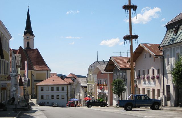
Obernzell is a charming town in Bavaria, Germany, located along the banks of the Danube River. The area is known for its beautiful natural landscapes, making it an excellent destination for hiking enthusiasts. Here’s what you can expect when hiking in Obernzell:
Hiking Trails
-
Danube River Trails: The Danube has various paths along its banks, offering stunning views and a relatively flat terrain. These trails are perfect for leisurely hikes and can be enjoyed by hikers of all levels.
-
Forest Trails: The area surrounding Obernzell is rich in forests, providing plenty of options for more challenging hikes. The trails here can lead you through scenic woodlands, giving you a chance to experience the local flora and fauna.
-
Hüttenberg Trail: This is a popular local hiking route that offers a moderate challenge and excellent views over the Danube River and the surrounding hills.
-
Cultural Trails: Some trails focus on the cultural heritage of the area, leading hikers to historical sites and landmarks, such as local churches, castles, and traditional Bavarian villages.
What to Expect
- Beautiful Scenery: Enjoy breathtaking views of the Danube and the surrounding hills. The area is particularly stunning in the fall when the leaves change color.
- Wildlife Watching: The natural habitats around Obernzell are home to various wildlife species, making it a great place for birdwatching and enjoying nature.
- Culinary Delights: Don’t forget to explore the local cuisine in Obernzell. Many hiking trails may lead you to quaint villages where you can enjoy traditional Bavarian dishes.
Preparation
- Gear: Good hiking shoes are essential. Depending on the season, bring clothing that layers well, along with weather-proof gear if rain is in the forecast.
- Maps and Guides: While many trails are well-marked, having a map or a guide app can help you navigate more unknown paths.
- Safety Precautions: Always inform someone of your hiking plans, especially if you’re heading out on more remote trails. Bring plenty of water and snacks for your hike.
Seasonality
- Spring and Fall: These seasons are particularly beautiful for hiking due to mild weather and vibrant scenery.
- Summer: Early morning hikes can be refreshing, but be sure to stay hydrated as temperatures can rise.
- Winter: Snow-covered trails can be picturesque, but check local conditions and consider snow gear for safety.
Local Amenities
Obernzell offers various facilities for hikers, including accommodation options, restaurants, and shops where you can purchase supplies or meals.
Overall, hiking in Obernzell is a rewarding experience with its variety of trails, stunning landscapes, and rich cultural history. Whether you're looking for a leisurely walk along the river or a more challenging trek through the forests, you’ll find something to enjoy in this beautiful part of Bavaria.
- Country:

- Postal Code: 94107; 94130; W-8391; 8391
- Local Dialing Code: 08591
- Licence Plate Code: PA
- Coordinates: 48° 33' 16" N, 13° 38' 17" E


- GPS tracks (wikiloc): [Link]
- AboveSeaLevel: 294 м m
- Area: 18.20 sq km
- Population: 3425
- Web site: https://www.obernzell.de/
- Wikipedia en: wiki(en)
- Wikipedia: wiki(de)
- Wikidata storage: Wikidata: Q268431
- Wikipedia Commons Category: [Link]
- Freebase ID: [/m/02rfqpg]
- GeoNames ID: Alt: [2859512]
- VIAF ID: Alt: [122427363]
- OSM relation ID: [958111]
- GND ID: Alt: [4116695-4]
- Library of Congress authority ID: Alt: [nr91035335]
- Historical Gazetteer (GOV) ID: [OBEEL1JN68TN]
- Bavarikon ID: [ODB_A00001567]
- German municipality key: 09275137
- Bavarian monument authority ID: E-2-75-137-1
Shares border with regions:


Thyrnau
- municipality of Germany
Hiking in Thyrnau
Thyrnau is a picturesque village located in the Lower Bavaria region of Germany. Nestled near the Danube River and surrounded by scenic landscapes, it offers various hiking opportunities for outdoor enthusiasts....
- Country:
- Postal Code: 94136
- Local Dialing Code: 08501
- Licence Plate Code: PA
- Coordinates: 48° 36' 54" N, 13° 32' 13" E
- GPS tracks (wikiloc): [Link]
- AboveSeaLevel: 456 м m
- Area: 33.74 sq km
- Population: 3534
- Web site: [Link]

Untergriesbach
- municipality of Germany
Hiking in Untergriesbach
Untergriesbach, located in Bavaria, Germany, is a charming area surrounded by beautiful natural landscapes, making it an excellent destination for hiking enthusiasts. Here are some key points about hiking in and around Untergriesbach:...
- Country:
- Postal Code: 94107; W-8391; 8391
- Local Dialing Code: 08593
- Licence Plate Code: PA
- Coordinates: 48° 34' 25" N, 13° 40' 2" E
- GPS tracks (wikiloc): [Link]
- AboveSeaLevel: 556 м m
- Area: 73.61 sq km
- Population: 5814
- Web site: [Link]

Vichtenstein
- municipality in Austria
Hiking in Vichtenstein
Vichtenstein, nestled in the heart of Europe, is recognized for its stunning landscapes, which include mountains, valleys, and picturesque villages. While you might be referring to "Liechtenstein," the charming, landlocked principality between Switzerland and Austria, it's a fantastic destination for hiking enthusiasts....
- Country:

- Postal Code: 4091
- Local Dialing Code: 07714
- Licence Plate Code: SD
- Coordinates: 48° 32' 0" N, 13° 39' 0" E
- GPS tracks (wikiloc): [Link]
- AboveSeaLevel: 554 м m
- Area: 10.7 sq km
- Population: 611
- Web site: [Link]

Esternberg
- municipality in Austria
Hiking in Esternberg
Esternberg, located in Austria, is a charming destination for hiking enthusiasts. Nestled in the scenic landscapes of Upper Austria, the area offers a range of beautiful trails that cater to various skill levels, from beginners to experienced hikers....
- Country:
- Postal Code: 4092
- Local Dialing Code: 07714
- Licence Plate Code: SD
- Coordinates: 48° 33' 0" N, 13° 34' 0" E
- GPS tracks (wikiloc): [Link]
- AboveSeaLevel: 510 м m
- Area: 40 sq km
- Population: 2855
- Web site: [Link]