Oberpullendorf District (Bezirk Oberpullendorf)

- district of Austria
 Hiking in Oberpullendorf District
Oberpullendorf District, located in the eastern part of Austria's Burgenland region, offers a variety of hiking opportunities that showcase its natural beauty and cultural heritage. The area is characterized by rolling hills, vineyards, forests, and charming villages, making it a delightful destination for outdoor enthusiasts.
Popular Hiking Trails
-
The Burgenland Trail (Burgenlandweg): This long-distance trail runs through the entire Burgenland region, including parts of Oberpullendorf. It offers multiple sections with varying difficulty, allowing hikers to experience scenic views, local flora and fauna, and historically significant sites.
-
Nature Trails: The district features several designated nature trails, which are excellent for appreciating the local ecosystem. These paths often have informative signs that provide insights into the area's wildlife and plant species.
-
Vineyard Trails: The region is renowned for its vineyards. Some trails wind through vineyards, offering a combination of hiking and wine tasting. You can familiarize yourself with local wine production while enjoying beautiful vineyard landscapes.
-
Forest Trails: The nearby forests provide a tranquil hiking experience. These paths can be a bit more rugged, ideal for those looking for solitude and a chance to connect with nature.
Points of Interest
-
Schwarzenbach: This area offers stunning views and is a great place to start your hike. There are routes leading to nearby hills that provide panoramic vistas of the region.
-
Cultural Sites: As you hike, you might come across historical landmarks, such as old churches or remnants of castles that add cultural value to your experience.
Tips for Hiking in Oberpullendorf
-
Seasonal Considerations: Spring and fall are particularly beautiful times to hike in this district due to pleasant weather and colorful landscapes. Summers can be hot, while winters may have snow, affecting trail conditions.
-
Gear: Wear comfortable hiking shoes and dress in layers, as temperatures can change throughout the day. Bringing water and snacks is essential, especially for longer hikes.
-
Local Regulations: Be aware of and respect local regulations regarding nature conservation. Stick to marked trails to protect wildlife habitats.
-
Maps and Guidance: Consider downloading hiking maps or using local guides for the best experience. The Burgenland Tourism website provides valuable resources and information on trails.
Oberpullendorf is a wonderful region for those looking to combine hiking with the enjoyment of nature and local culture. Enjoy your adventure!
- Country:

- Capital: Oberpullendorf
- Licence Plate Code: OP
- Coordinates: 47° 32' 2" N, 16° 29' 46" E


- GPS tracks (wikiloc): [Link]
- AboveSeaLevel: 243 м m
- Population: 37692
- Wikipedia en: wiki(en)
- Wikipedia: wiki(de)
- Wikidata storage: Wikidata: Q748891
- Wikipedia Commons Category: [Link]
- Freebase ID: [/m/06vtrq]
- GeoNames ID: Alt: [2769811]
- GND ID: Alt: [4802304-8]
- archINFORM location ID: [14664]
- Library of Congress authority ID: Alt: [nr2005017898]
Includes regions:
Piringsdorf
- municipality in Austria
Hiking in Piringsdorf
Piringsdorf is a charming village located in the Burgenland region of Austria, known for its scenic landscapes and tranquil atmosphere. Hiking in and around Piringsdorf offers a great opportunity to experience the natural beauty of the area, characterized by rolling hills, vineyards, forests, and picturesque countryside....
- Country:
- Postal Code: 7373
- Local Dialing Code: 02616
- Licence Plate Code: OP
- Coordinates: 47° 26' 56" N, 16° 25' 6" E
- GPS tracks (wikiloc): [Link]
- AboveSeaLevel: 343 м m
- Area: 16.1 sq km
- Population: 847
- Web site: [Link]
Kaisersdorf
- municipality in Austria
Hiking in Kaisersdorf
Kaisersdorf is a charming village located in Austria, known for its scenic landscapes and tranquil surroundings. While it may not be as well-known as some of the larger hiking areas in the country, it offers opportunities for outdoor enthusiasts to explore beautiful trails and enjoy nature....
- Country:
- Postal Code: 7342
- Local Dialing Code: 02617
- Licence Plate Code: OP
- Coordinates: 47° 32' 3" N, 16° 23' 45" E
- GPS tracks (wikiloc): [Link]
- AboveSeaLevel: 360 м m
- Area: 12.5 sq km
- Population: 620
- Web site: [Link]

Neutal
- municipality in Austria
Hiking in Neutal
It seems like there might be a typo in your request regarding "Neutal." If you meant a specific place, such as "Neutral" or a location with a similar name, please clarify....
- Country:
- Postal Code: 7343
- Local Dialing Code: 02618
- Licence Plate Code: OP
- Coordinates: 47° 32' 45" N, 16° 26' 45" E
- GPS tracks (wikiloc): [Link]
- AboveSeaLevel: 274 м m
- Area: 11.6 sq km
- Population: 1094
- Web site: [Link]

Oberpullendorf
- Austrian town
Hiking in Oberpullendorf
Oberpullendorf, situated in the Burgenland region of Austria, offers several opportunities for hiking enthusiasts. The area is known for its beautiful landscapes, rolling hills, vineyards, and forests, making it a great destination for outdoor activities. Here are some highlights and considerations for hiking in Oberpullendorf:...
- Country:
- Postal Code: 7350
- Local Dialing Code: 02612
- Licence Plate Code: OP
- Coordinates: 47° 30' 0" N, 16° 31' 0" E
- GPS tracks (wikiloc): [Link]
- AboveSeaLevel: 243 м m
- Area: 12.65 sq km
- Population: 3188
- Web site: [Link]
Lackendorf
- municipality in Austria
Hiking in Lackendorf
Lackendorf is a picturesque area that offers beautiful landscapes and a variety of hiking opportunities. It is typically characterized by rolling hills, lush forests, and scenic viewpoints. Here are some key points to consider when hiking in Lackendorf:...
- Country:
- Postal Code: 7321
- Local Dialing Code: 02619
- Licence Plate Code: OP
- Coordinates: 47° 35' 22" N, 16° 30' 4" E
- GPS tracks (wikiloc): [Link]
- AboveSeaLevel: 294 м m
- Area: 12.7 sq km
- Population: 604
- Web site: [Link]
Frankenau-Unterpullendorf
- municipality in Austria
Hiking in Frankenau-Unterpullendorf
Frankenau-Unterpullendorf is a charming area in Austria known for its natural beauty and scenic hiking trails. This region is characterized by rolling hills, lush forests, and picturesque landscapes, making it an attractive destination for hikers of all levels....
- Country:
- Local Dialing Code: 02615
- Licence Plate Code: OP
- Coordinates: 47° 26' 56" N, 16° 36' 29" E
- GPS tracks (wikiloc): [Link]
- AboveSeaLevel: 243 м m
- Area: 30 sq km
- Population: 1109
- Web site: [Link]

Deutschkreutz
- municipality in Austria
Hiking in Deutschkreutz
Deutschkreutz, located in Austria’s Burgenland region, is a charming village known for its picturesque landscapes and wine culture. Hiking in this area offers a variety of trails that cater to different skill levels, with opportunities to explore lush vineyards, historical sites, and the natural beauty of the surrounding hills....
- Country:
- Postal Code: 7301
- Local Dialing Code: 02613
- Licence Plate Code: OP
- Coordinates: 47° 36' 6" N, 16° 37' 41" E
- GPS tracks (wikiloc): [Link]
- AboveSeaLevel: 180 м m
- Area: 34.1 sq km
- Population: 3088
- Web site: [Link]
Mannersdorf an der Rabnitz
- municipality in Austria
Hiking in Mannersdorf an der Rabnitz
Mannersdorf an der Rabnitz is a beautiful village located in Burgenland, Austria, known for its picturesque landscapes and natural surroundings. The area offers several hiking opportunities that allow you to explore the stunning scenery, including forests, hills, and the Rabnitz river....
- Country:
- Postal Code: 7444
- Local Dialing Code: 02611
- Licence Plate Code: OP
- Coordinates: 47° 25' 44" N, 16° 31' 40" E
- GPS tracks (wikiloc): [Link]
- AboveSeaLevel: 245 м m
- Area: 38.42 sq km
- Population: 1795
- Web site: [Link]

Horitschon
- municipality in Austria
Hiking in Horitschon
Horitschon is a small village located in the Burgenland region of Austria, known for its beautiful landscapes, vineyards, and relatively mild climate. The area offers various hiking opportunities that showcase its natural beauty and cultural heritage....
- Country:
- Postal Code: 7312
- Local Dialing Code: 02610
- Licence Plate Code: OP
- Coordinates: 47° 35' 22" N, 16° 32' 48" E
- GPS tracks (wikiloc): [Link]
- AboveSeaLevel: 239 м m
- Area: 18.73 sq km
- Population: 1861
- Web site: [Link]
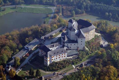
Lockenhaus
- municipality in Austria
Hiking in Lockenhaus
Lockenhaus, located in the Austrian region of Burgenland near the border with Hungary, offers a variety of beautiful hiking trails that showcase the scenic landscape, rich history, and diverse flora and fauna of the area. Here’s an overview of what you can expect when hiking in Lockenhaus:...
- Country:
- Postal Code: 7442
- Local Dialing Code: 02616
- Licence Plate Code: OP
- Coordinates: 47° 24' 25" N, 16° 25' 0" E
- GPS tracks (wikiloc): [Link]
- AboveSeaLevel: 336 м m
- Area: 58.9 sq km
- Population: 2066
- Web site: [Link]

Unterrabnitz-Schwendgraben
- municipality in Austria
Hiking in Unterrabnitz-Schwendgraben
Unterrabnitz-Schwendgraben is a beautiful area located in Austria, known for its serene landscapes and abundant nature. Here are some points to consider if you're planning to hike there:...
- Country:
- Postal Code: 7371
- Local Dialing Code: 02616
- Licence Plate Code: OP
- Coordinates: 47° 27' 16" N, 16° 22' 35" E
- GPS tracks (wikiloc): [Link]
- AboveSeaLevel: 331 м m
- Area: 13.9 sq km
- Population: 650
- Web site: [Link]
Großwarasdorf
- municipality in Austria
Hiking in Großwarasdorf
Großwarasdorf, located in the Burgenland region of Austria, is known for its serene landscapes, rolling hills, and vineyards. While it may not be as well-known as some of Austria's larger hiking destinations, it offers a variety of scenic trails that can provide a peaceful hiking experience amidst charming rural scenery....
- Country:
- Postal Code: 7304
- Local Dialing Code: 02614
- Licence Plate Code: OP
- Coordinates: 47° 32' 21" N, 16° 33' 12" E
- GPS tracks (wikiloc): [Link]
- AboveSeaLevel: 244 м m
- Area: 42.5 sq km
- Population: 1381
- Web site: [Link]

Raiding
- municipality in Austria
Hiking in Raiding
Raiding, a charming village in Austria’s Burgenland region, offers a picturesque setting for hiking enthusiasts. Nestled amidst rolling hills and vineyards, it provides access to a variety of hiking trails that cater to different skill levels....
- Country:
- Postal Code: 7321
- Local Dialing Code: 02619
- Licence Plate Code: OP
- Coordinates: 47° 33' 58" N, 16° 31' 53" E
- GPS tracks (wikiloc): [Link]
- AboveSeaLevel: 253 м m
- Area: 13.1 sq km
- Population: 865
- Web site: [Link]

Kobersdorf
- municipality in Austria
Hiking in Kobersdorf
Kobersdorf is a charming village located in Austria, specifically in the Burgenland region, known for its scenic landscapes, rolling hills, and extensive hiking opportunities. Here are some highlights to consider when planning a hiking trip in and around Kobersdorf:...
- Country:
- Postal Code: 7332
- Local Dialing Code: 02618
- Licence Plate Code: OP
- Coordinates: 47° 35' 39" N, 16° 22' 42" E
- GPS tracks (wikiloc): [Link]
- AboveSeaLevel: 420 м m
- Area: 27.3 sq km
- Population: 1883
- Web site: [Link]
Ritzing
- municipality in Austria
Hiking in Ritzing
Ritzing, located in Austria, is known for its scenic landscapes and beautiful hiking trails, making it a great destination for outdoor enthusiasts. Here are some highlights and tips for hiking in the Ritzing area:...
- Country:
- Postal Code: 7323
- Local Dialing Code: 02619
- Licence Plate Code: OP
- Coordinates: 47° 36' 41" N, 16° 29' 47" E
- GPS tracks (wikiloc): [Link]
- AboveSeaLevel: 384 м m
- Area: 17.7 sq km
- Population: 865
- Web site: [Link]

Steinberg-Dörfl
- municipality in Austria
Hiking in Steinberg-Dörfl
Steinberg-Dörfl is a charming village located in the Austrian Alps, known for its beautiful landscapes and outdoor activities, including hiking. The surrounding region offers numerous trails that cater to a variety of skill levels, from leisurely walks to more challenging hikes....
- Country:
- Postal Code: 7453
- Local Dialing Code: 02612
- Licence Plate Code: OP
- Coordinates: 47° 28' 36" N, 16° 29' 12" E
- GPS tracks (wikiloc): [Link]
- AboveSeaLevel: 282 м m
- Area: 37.1 sq km
- Population: 1291
- Web site: [Link]

Lutzmannsburg
- municipality in Austria
Hiking in Lutzmannsburg
Lutzmannsburg, located in Austria's Burgenland region, is well-known for its beautiful landscapes, particularly the rolling hills, vineyards, and natural areas that provide great hiking opportunities. Here’s what to know about hiking in Lutzmannsburg:...
- Country:
- Postal Code: 7361
- Local Dialing Code: 02615
- Licence Plate Code: OP
- Coordinates: 47° 27' 51" N, 16° 38' 27" E
- GPS tracks (wikiloc): [Link]
- AboveSeaLevel: 204 м m
- Area: 23.2 sq km
- Population: 861
- Web site: [Link]

Weppersdorf
- municipality in Austria
Hiking in Weppersdorf
Weppersdorf, located in Austria, is a beautiful area that offers several hiking opportunities characterized by picturesque landscapes, rolling hills, and a tranquil environment. The region is ideal for those looking for both short and longer hikes, suitable for various skill levels....
- Country:
- Postal Code: 7331
- Local Dialing Code: 02618
- Licence Plate Code: OP
- Coordinates: 47° 34' 46" N, 16° 25' 37" E
- GPS tracks (wikiloc): [Link]
- AboveSeaLevel: 315 м m
- Area: 24.74 sq km
- Population: 1826
- Web site: [Link]
Lackenbach
- municipality in Austria
Hiking in Lackenbach
Lackenbach, located in Austria's Burgenland region, offers a unique mix of natural beauty and outdoor recreational opportunities. The area is characterized by its picturesque landscapes, including forests, rolling hills, and nearby lakes. Here are some key points to consider when hiking in Lackenbach:...
- Country:
- Postal Code: 7322
- Local Dialing Code: 02619
- Licence Plate Code: OP
- Coordinates: 47° 35' 22" N, 16° 27' 46" E
- GPS tracks (wikiloc): [Link]
- AboveSeaLevel: 313 м m
- Area: 18.1 sq km
- Population: 1167
- Web site: [Link]

Stoob
- municipality in Austria
Hiking in Stoob
Stoob is a small village located in Austria, known for its beautiful landscapes and opportunities for hiking. While it may not be as widely recognized as some of Austria's larger hiking destinations, Stoob offers a peaceful environment and scenic trails suitable for outdoor enthusiasts....
- Country:
- Postal Code: 7344
- Local Dialing Code: 02612
- Licence Plate Code: OP
- Coordinates: 47° 31' 48" N, 16° 28' 35" E
- GPS tracks (wikiloc): [Link]
- AboveSeaLevel: 265 м m
- Area: 17.38 sq km
- Population: 1386
- Web site: [Link]

Draßmarkt
- municipality in Austria
Hiking in Draßmarkt
Draßmarkt is a small village located in the Burgenland region of Austria, known for its picturesque landscapes and proximity to the Austrian countryside. While it may not be as well-known as some larger hiking destinations, there are still plenty of opportunities to explore the natural beauty of the area....
- Country:
- Postal Code: 7372
- Local Dialing Code: 02617
- Licence Plate Code: OP
- Coordinates: 47° 30' 46" N, 16° 24' 2" E
- GPS tracks (wikiloc): [Link]
- AboveSeaLevel: 341 м m
- Area: 36.2 sq km
- Population: 1388
- Web site: [Link]
Weingraben
- municipality in Austria
Hiking in Weingraben
Weingraben is a small village located in Austria, specifically in the Burgenland region. It's surrounded by picturesque landscapes, rolling hills, and vineyards, making it a lovely destination for hiking enthusiasts. Here are some highlights for hiking in and around Weingraben:...
- Country:
- Postal Code: 7372
- Local Dialing Code: 02617
- Licence Plate Code: OP
- Coordinates: 47° 30' 51" N, 16° 21' 45" E
- GPS tracks (wikiloc): [Link]
- AboveSeaLevel: 415 м m
- Area: 9.22 sq km
- Population: 363
Oberloisdorf
- municipality in Austria
Hiking in Oberloisdorf
Oberloisdorf is a small village located in Austria, close to the border with Hungary. While it may not be as well-known as some of the larger hiking destinations in Austria, it offers a serene natural backdrop that is perfect for those looking to enjoy the outdoors and explore its surroundings....
- Country:
- Postal Code: 7451
- Local Dialing Code: 02611
- Licence Plate Code: OP
- Coordinates: 47° 26' 48" N, 16° 30' 26" E
- GPS tracks (wikiloc): [Link]
- AboveSeaLevel: 254 м m
- Area: 10.65 sq km
- Population: 806
- Web site: [Link]

Pilgersdorf
- municipality in Austria
Hiking in Pilgersdorf
Pilgersdorf is a small village located in the Burgenland region of Austria. The area is known for its picturesque landscapes, making it a great destination for hiking enthusiasts. While it may not be as widely recognized as larger hiking destinations, Pilgersdorf offers opportunities to explore the natural beauty of the surrounding countryside....
- Country:
- Postal Code: 7441
- Local Dialing Code: 02616
- Licence Plate Code: OP
- Coordinates: 47° 26' 29" N, 16° 21' 0" E
- GPS tracks (wikiloc): [Link]
- AboveSeaLevel: 375 м m
- Area: 43.9 sq km
- Population: 1656
- Web site: [Link]
Markt Sankt Martin
- municipality in Austria
Hiking in Markt Sankt Martin
Markt Sankt Martin is located in the Burgenland region of Austria, known for its scenic landscapes and outdoor activities. Hiking in this area offers a blend of natural beauty, cultural experiences, and opportunities to explore the local flora and fauna....
- Country:
- Postal Code: 7341
- Local Dialing Code: 02618
- Licence Plate Code: OP
- Coordinates: 47° 33' 43" N, 16° 25' 30" E
- GPS tracks (wikiloc): [Link]
- AboveSeaLevel: 314 м m
- Area: 32.11 sq km
- Population: 1198
- Web site: [Link]

Neckenmarkt
- municipality in Austria
Hiking in Neckenmarkt
Neckenmarkt is a charming village located in Austria, known for its picturesque landscapes and opportunities for outdoor activities, including hiking. Nestled in the foothills of the Alps, Neckenmarkt offers a variety of trails that cater to different skill levels, making it an excellent destination for both seasoned hikers and beginners....
- Country:
- Postal Code: 7311
- Local Dialing Code: 2610
- Licence Plate Code: OP
- Coordinates: 47° 36' 0" N, 16° 32' 49" E
- GPS tracks (wikiloc): [Link]
- AboveSeaLevel: 225 м m
- Area: 26.92 sq km
- Population: 1680
- Web site: [Link]
Unterfrauenhaid
- municipality in Austria
Hiking in Unterfrauenhaid
Unterfrauenhaid is a picturesque village located in Austria, known for its beautiful landscapes and outdoor activities, including hiking. The region offers several trails that cater to various skill levels, providing hikers the opportunity to experience the natural beauty of the area....
- Country:
- Postal Code: 7321
- Local Dialing Code: 02619
- Licence Plate Code: OP
- Coordinates: 47° 34' 21" N, 16° 29' 59" E
- GPS tracks (wikiloc): [Link]
- AboveSeaLevel: 323 м m
- Area: 10.79 sq km
- Population: 681
- Web site: [Link]


Nikitsch
- municipality in Austria
Hiking in Nikitsch
Nikitsch is a charming village located in Austria, specifically in the Burgenland region. It's surrounded by beautiful landscapes, featuring vineyards, rolling hills, and natural reserves that make it a lovely destination for hiking enthusiasts....
- Country:
- Postal Code: 7302
- Local Dialing Code: 02614
- Licence Plate Code: OP
- Coordinates: 47° 32' 9" N, 16° 39' 33" E
- GPS tracks (wikiloc): [Link]
- AboveSeaLevel: 228 м m
- Area: 50.76 sq km
- Population: 1405
- Web site: [Link]