Oberwart District (Bezirk Oberwart)

- district of Austria
 Hiking in Oberwart District
Oberwart District, located in the Burgenland region of Austria, offers a variety of hiking opportunities amid picturesque landscapes, rolling hills, and vineyards. Here are some key points to consider if you’re planning a hiking trip in this area:
Trails and Routes
-
Römerland-Carnuntum: This area features several well-marked hiking trails passing through vineyards, historical sites, and beautiful nature. Look for themed trails that provide insights into the local culture and history.
-
Nature Parks: The nearby National Park Neusiedler See-Seewinkel offers expansive hiking options, particularly for birdwatching and enjoying wetlands. This park represents a unique habitat with plenty of paths to explore.
-
Hiking Loops: There are various circular trails, generally ranging from easy to moderate levels, catering to different skill levels. For instance, the circular trail around Oberwart gives you a chance to experience local flora and fauna while enjoying scenic views.
Scenic Views and Highlights
- Vineyards: The region is known for its wine production, particularly white wines. Hiking through vineyards can be rewarding, and you might find opportunities for wine tasting.
- Historical Sites: Oberwart has many heritage sites, including churches and remnants of old fortifications, that add interest to your hikes.
Best Times to Hike
- Spring and Fall: These seasons are ideal for hiking in Oberwart, as temperatures are usually mild, and you can enjoy the beauty of blooming flowers or autumn colors.
- Summer: This time can get quite hot, so early morning or late afternoon hikes are recommended to avoid the heat of the day.
Preparation Tips
- Footwear: Good hiking boots are essential, especially if you plan to tackle uneven terrain.
- Hydration and Snacks: Carry plenty of water and some snacks, particularly during longer hikes.
- Maps and Guidance: While trails are generally well-marked, carrying a local map or a GPS device for navigation can be helpful.
Local Amenities
- Accommodations: There are several guesthouses and small hotels in the region that cater to hikers, providing convenient access to trails.
- Transport: Public transport options can sometimes offer ways to start or end your hikes, though having a car can provide more flexibility.
In summary, Oberwart District provides an excellent balance of nature, culture, and history for hiking enthusiasts. Be sure to plan accordingly and enjoy your hike!
- Country:

- Licence Plate Code: OW
- Coordinates: 47° 17' 38" N, 16° 14' 35" E


- GPS tracks (wikiloc): [Link]
- AboveSeaLevel: 314 м m
- Population: 53955
- Wikipedia en: wiki(en)
- Wikipedia: wiki(de)
- Wikidata storage: Wikidata: Q660230
- Wikipedia Commons Category: [Link]
- Wikipedia Commons Maps Category: [Link]
- Freebase ID: [/m/06m55t]
- GeoNames ID: Alt: [2769621]
- archINFORM location ID: [14665]
Includes regions:

Deutsch Schützen-Eisenberg
- municipality in Austria
Hiking in Deutsch Schützen-Eisenberg
Deutsch Schützen-Eisenberg is a charming village located in the Burgenland region of Austria, known for its picturesque landscapes, rolling hills, vineyards, and serene atmosphere, making it an excellent destination for hiking enthusiasts....
- Country:
- Postal Code: 7474
- Local Dialing Code: 03365
- Licence Plate Code: OW
- Coordinates: 47° 10' 0" N, 16° 26' 0" E
- GPS tracks (wikiloc): [Link]
- AboveSeaLevel: 227 м m
- Area: 28.43 sq km
- Population: 1126
- Web site: [Link]

Rechnitz
- municipality in Austria
Hiking in Rechnitz
Rechnitz, a small village in Burgenland, Austria, offers a charming setting for hiking enthusiasts. The region is characterized by its rolling hills, vineyards, and scenic landscapes, making it an excellent destination for nature lovers. Here are some key points to consider when hiking in and around Rechnitz:...
- Country:
- Postal Code: 7471
- Local Dialing Code: 03363
- Licence Plate Code: OW
- Coordinates: 47° 18' 25" N, 16° 26' 18" E
- GPS tracks (wikiloc): [Link]
- AboveSeaLevel: 366 м m
- Area: 43.8 sq km
- Population: 3054
- Web site: [Link]


Stadtschlaining
- municipality in Austria
Hiking in Stadtschlaining
Stadtschlaining, located in the Austrian state of Burgenland, is a charming town surrounded by picturesque landscapes that offer excellent hiking opportunities. The region is characterized by rolling hills, lush forests, and scenic views, making it an ideal destination for outdoor enthusiasts....
- Country:
- Postal Code: 7461
- Local Dialing Code: 03355
- Licence Plate Code: OW
- Coordinates: 47° 19' 22" N, 16° 16' 27" E
- GPS tracks (wikiloc): [Link]
- AboveSeaLevel: 409 м m
- Area: 42.1 sq km
- Population: 1980
- Web site: [Link]
Pinkafeld
- municipality in Austria
Hiking in Pinkafeld
Pinkafeld, located in Burgenland, Austria, offers a variety of beautiful hiking trails set against a backdrop of natural beauty and local culture. The region features gently rolling hills, forests, and a peaceful atmosphere, making it an ideal spot for hikers of all skill levels....
- Country:
- Postal Code: 7423
- Local Dialing Code: 03357
- Licence Plate Code: OW
- Coordinates: 47° 22' 18" N, 16° 7' 19" E
- GPS tracks (wikiloc): [Link]
- AboveSeaLevel: 399 м m
- Area: 27.43 sq km
- Population: 5779
- Web site: [Link]


Wolfau
- municipality in Austria
Hiking in Wolfau
Wolfau, located in Austria, is a charming destination for hikers thanks to its scenic landscapes and tranquil environment. The area is characterized by rolling hills, lush forests, and picturesque meadows, making it suitable for various hiking levels. Here are some highlights and tips for hiking in Wolfau:...
- Country:
- Postal Code: 7412
- Local Dialing Code: 03356
- Licence Plate Code: OW
- Coordinates: 47° 15' 27" N, 16° 5' 47" E
- GPS tracks (wikiloc): [Link]
- AboveSeaLevel: 340 м m
- Area: 15.02 sq km
- Population: 1436
- Web site: [Link]

Schachendorf
- municipality in Austria
Hiking in Schachendorf
Schachendorf is a charming village located in the Austrian state of Burgenland, close to the Hungarian border. The region surrounding Schachendorf offers beautiful landscapes, rolling hills, and serene countryside, making it a fantastic destination for hiking enthusiasts....
- Country:
- Postal Code: 7472
- Local Dialing Code: 03364
- Licence Plate Code: OW
- Coordinates: 47° 15' 53" N, 16° 26' 3" E
- GPS tracks (wikiloc): [Link]
- AboveSeaLevel: 286 м m
- Area: 22.3 sq km
- Population: 765
- Web site: [Link]
Litzelsdorf
- municipality in Austria
Hiking in Litzelsdorf
Litzelsdorf is a charming village located in the Burgenland region of Austria, surrounded by picturesque landscapes that make it an appealing destination for hiking enthusiasts. Here are some key aspects to consider when hiking in and around Litzelsdorf:...
- Country:
- Postal Code: 7532
- Local Dialing Code: 03358
- Licence Plate Code: OW
- Coordinates: 47° 12' 31" N, 16° 9' 46" E
- GPS tracks (wikiloc): [Link]
- AboveSeaLevel: 292 м m
- Area: 13.9 sq km
- Population: 1181
- Web site: [Link]
Schandorf
- municipality in Austria
Hiking in Schandorf
Schandorf is a picturesque village located in Austria, known for its serene landscapes and proximity to nature. While it may not be as widely recognized as some of Austria's more famous hiking destinations, Schandorf offers charming trails and nature-watching opportunities that can be perfect for a peaceful hike....
- Country:
- Postal Code: 7472
- Local Dialing Code: 03364
- Licence Plate Code: OW
- Coordinates: 47° 14' 33" N, 16° 25' 5" E
- GPS tracks (wikiloc): [Link]
- AboveSeaLevel: 260 м m
- Area: 11.26 sq km
- Population: 276
- Web site: [Link]

Kohfidisch
- municipality in Austria
Hiking in Kohfidisch
Kohfidisch, a small village in Austria, offers a charming and less-traveled hiking experience, ideal for those looking to explore the beauty of the Burgenland region. While the immediate area around Kohfidisch may not have extensive hiking trails, it is well-connected to nearby nature areas and regional paths....
- Country:
- Postal Code: 7512
- Local Dialing Code: 03366
- Licence Plate Code: OW
- Coordinates: 47° 10' 25" N, 16° 21' 26" E
- GPS tracks (wikiloc): [Link]
- AboveSeaLevel: 258 м m
- Area: 31.34 sq km
- Population: 1462
- Web site: [Link]

Weiden bei Rechnitz
- municipality in Austria
Hiking in Weiden bei Rechnitz
Weiden bei Rechnitz is a charming village located in Burgenland, Austria, surrounded by picturesque landscapes that make it a great destination for hiking enthusiasts. The region is characterized by rolling hills, vineyards, and scenic forests, providing various trails suitable for all levels of hikers....
- Country:
- Postal Code: 7463
- Local Dialing Code: 03355
- Licence Plate Code: OW
- Coordinates: 47° 18' 9" N, 16° 20' 51" E
- GPS tracks (wikiloc): [Link]
- AboveSeaLevel: 330 м m
- Area: 39.84 sq km
- Population: 824
- Web site: [Link]
Jabing
- municipality in Austria
Hiking in Jabing
Jabing, a region in the northern part of Austria, offers some wonderful hiking opportunities, particularly for those who enjoy stunning natural landscapes, rolling hills, and views of the Alps. The area is known for its lush greenery, picturesque villages, and well-marked trails suitable for various skill levels....
- Country:
- Postal Code: 7503
- Local Dialing Code: 03362
- Licence Plate Code: OW
- Coordinates: 47° 14' 18" N, 16° 16' 18" E
- GPS tracks (wikiloc): [Link]
- AboveSeaLevel: 279 м m
- Area: 7.8 sq km
- Population: 734

Markt Allhau
- municipality in Austria
Hiking in Markt Allhau
Markt Allhau, a quaint community located in Burgenland, Austria, offers several opportunities for hiking enthusiasts. The region is characterized by its beautiful landscapes, rolling hills, and diverse flora and fauna. Here are some highlights if you're considering hiking in this area:...
- Country:
- Postal Code: 7411
- Local Dialing Code: 03356
- Licence Plate Code: OW
- Coordinates: 47° 17' 29" N, 16° 4' 49" E
- GPS tracks (wikiloc): [Link]
- AboveSeaLevel: 349 м m
- Area: 32.3 sq km
- Population: 1845
- Web site: [Link]

Hannersdorf
- municipality in Austria
Hiking in Hannersdorf
Hannersdorf, located in Austria, is a charming little village that is surrounded by picturesque landscapes and offers a variety of hiking opportunities. Here are some key points to consider when hiking in and around Hannersdorf:...
- Country:
- Postal Code: 7473
- Local Dialing Code: 03364
- Licence Plate Code: OW
- Coordinates: 47° 13' 49" N, 16° 22' 52" E
- GPS tracks (wikiloc): [Link]
- AboveSeaLevel: 268 м m
- Area: 17.1 sq km
- Population: 758
- Web site: [Link]
Kemeten
- municipality in Austria
Hiking in Kemeten
Kemeten, a small village located in the southern region of Austria, is surrounded by beautiful natural landscapes, making it a great destination for hiking enthusiasts. This area is characterized by rolling hills, lush forests, and stunning views of the nearby mountain ranges, offering diverse trails for hikers of all levels. Here are some key points to consider if you're planning to hike in and around Kemeten:...
- Country:
- Postal Code: 7531
- Local Dialing Code: 03352
- Licence Plate Code: OW
- Coordinates: 47° 14' 59" N, 16° 9' 10" E
- GPS tracks (wikiloc): [Link]
- AboveSeaLevel: 305 м m
- Area: 20.66 sq km
- Population: 1464
- Web site: [Link]
Riedlingsdorf
- municipality in Austria
Hiking in Riedlingsdorf
Riedlingsdorf, located in Austria, offers a variety of hiking opportunities that showcase the picturesque landscapes characteristic of the region. The area is surrounded by natural beauty, including rolling hills, forests, and peaceful countryside, making it an excellent spot for both casual walkers and more serious hikers....
- Country:
- Postal Code: 7422
- Local Dialing Code: 03357
- Licence Plate Code: OW
- Coordinates: 47° 20' 47" N, 16° 7' 57" E
- GPS tracks (wikiloc): [Link]
- AboveSeaLevel: 317 м m
- Area: 16.13 sq km
- Population: 1619
- Web site: [Link]
Oberdorf im Burgenland
- municipality in Austria
Hiking in Oberdorf im Burgenland
Oberdorf im Burgenland is a quaint village in Austria, nestled in the northeastern part of the country, near the border with Hungary. The region, known for its scenic landscapes and rolling hills, offers several opportunities for hiking and outdoor exploration....
- Country:
- Postal Code: 7501
- Local Dialing Code: 03352
- Licence Plate Code: OW
- Coordinates: 47° 13' 11" N, 16° 13' 2" E
- GPS tracks (wikiloc): [Link]
- AboveSeaLevel: 364 м m
- Area: 9.24 sq km
- Population: 996
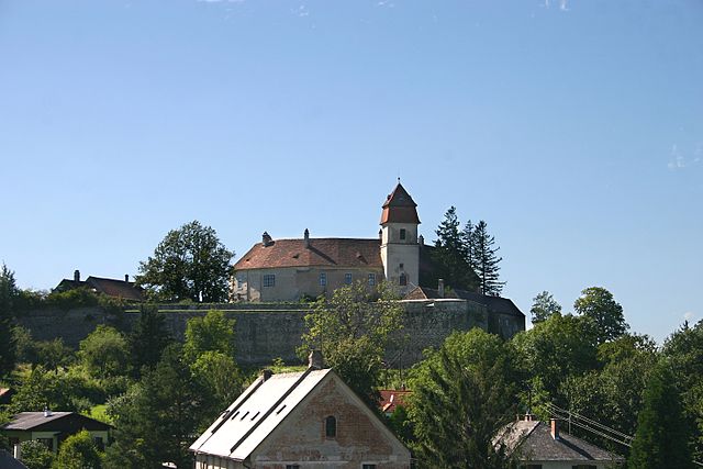
Bernstein im Burgenland
- municipality in Austria
Hiking in Bernstein im Burgenland
Bernstein im Burgenland is a picturesque village in Austria, located in the Burgenland region known for its stunning landscapes, rolling hills, and rich cultural heritage. Hiking in this area is a rewarding experience, as it offers numerous trails that allow you to explore the natural beauty and diverse ecosystems of the region....
- Country:
- Postal Code: 7434
- Local Dialing Code: 03354
- Licence Plate Code: OW
- Coordinates: 47° 24' 18" N, 16° 15' 20" E
- GPS tracks (wikiloc): [Link]
- AboveSeaLevel: 619 м m
- Area: 38.99 sq km
- Population: 2123
- Web site: [Link]

Unterwart
- municipality in Austria
Hiking in Unterwart
Unterwart is a picturesque village located in Austria, in the state of Burgenland, near the Hungarian border. It's surrounded by beautiful landscapes, rolling hills, vineyards, and a variety of trails that make it a great destination for hiking enthusiasts. Here are some key points about hiking in and around Unterwart:...
- Country:
- Postal Code: 7501
- Local Dialing Code: 03352
- Licence Plate Code: OW
- Coordinates: 47° 15' 32" N, 16° 14' 2" E
- GPS tracks (wikiloc): [Link]
- AboveSeaLevel: 306 м m
- Area: 20.2 sq km
- Population: 971
- Web site: [Link]


Mischendorf
- municipality in Austria
Hiking in Mischendorf
Mischendorf, located in the Burgenland region of Austria, offers scenic hiking opportunities that highlight the natural beauty of the area. Though it may not be as widely known as some larger hiking destinations, it has its own unique charm and picturesque landscapes. Here are some aspects to consider about hiking in and around Mischendorf:...
- Country:
- Postal Code: 7511
- Licence Plate Code: OW
- Coordinates: 47° 11' 39" N, 16° 18' 43" E
- GPS tracks (wikiloc): [Link]
- AboveSeaLevel: 272 м m
- Area: 26.2 sq km
- Population: 1589
- Web site: [Link]

Badersdorf
- municipality in Austria
Hiking in Badersdorf
Badersdorf is a small village in Austria, located in the beautiful landscapes of the country’s eastern regions. While it might not be as well-known as some larger hiking destinations, it offers a charming experience for those who seek tranquility and nature....
- Country:
- Postal Code: 7512
- Local Dialing Code: 03366
- Licence Plate Code: OW
- Coordinates: 47° 11' 45" N, 16° 22' 23" E
- GPS tracks (wikiloc): [Link]
- AboveSeaLevel: 268 м m
- Area: 8.64 sq km
- Population: 287
- Web site: [Link]
Loipersdorf-Kitzladen
- municipality in Austria
Hiking in Loipersdorf-Kitzladen
Loipersdorf-Kitzladen is a charming area located in the southeastern part of Austria, particularly known for its picturesque landscapes and wellness offerings, especially the renowned thermal baths in Loipersdorf. While it may not be as famous as the towering Alps, it provides various hiking opportunities that allow you to explore the beauty of the region....
- Country:
- Postal Code: 7410
- Local Dialing Code: 03359
- Licence Plate Code: OW
- Coordinates: 47° 20' 1" N, 16° 4' 40" E
- GPS tracks (wikiloc): [Link]
- AboveSeaLevel: 368 м m
- Area: 15.88 sq km
- Population: 1319
- Web site: [Link]

Großpetersdorf
- municipality in Austria
Hiking in Großpetersdorf
Großpetersdorf, located in Burgenland, Austria, is surrounded by beautiful landscapes that make it an appealing destination for hiking enthusiasts. The area offers a mix of gentle hills, forests, and fields, providing a variety of trails suitable for hikers of different skill levels....
- Country:
- Postal Code: 7503
- Local Dialing Code: 03362
- Licence Plate Code: OW
- Coordinates: 47° 14' 19" N, 16° 19' 7" E
- GPS tracks (wikiloc): [Link]
- AboveSeaLevel: 311 м m
- Area: 31.4 sq km
- Population: 3531
- Web site: [Link]

Unterkohlstätten
- municipality in Austria
Hiking in Unterkohlstätten
Unterkohlstätten is a charming village located in Austria, surrounded by beautiful natural landscapes that are perfect for hiking enthusiasts. The region offers a variety of trails that cater to different skill levels, making it suitable for both beginners and experienced hikers....
- Country:
- Postal Code: 7435
- Local Dialing Code: 03354
- Licence Plate Code: OW
- Coordinates: 47° 22' 33" N, 16° 19' 27" E
- GPS tracks (wikiloc): [Link]
- AboveSeaLevel: 503 м m
- Area: 29.1 sq km
- Population: 1029
- Web site: [Link]
Grafenschachen
- municipality in Austria
Hiking in Grafenschachen
Grafenschachen is not a widely recognized hiking destination, but it may refer to an area in Austria or other German-speaking regions where you can enjoy beautiful landscapes and outdoor activities. If you are exploring this area for hiking, here are some general tips and information to keep in mind:...
- Country:
- Postal Code: 7423
- Local Dialing Code: 03359
- Licence Plate Code: OW
- Coordinates: 47° 21' 47" N, 16° 3' 59" E
- GPS tracks (wikiloc): [Link]
- AboveSeaLevel: 394 м m
- Area: 9.94 sq km
- Population: 1225
- Web site: [Link]


Rotenturm an der Pinka
- municipality in Austria
Hiking in Rotenturm an der Pinka
Rotenturm an der Pinka is a charming village located in the southern part of Austria, in the state of Burgenland. It’s a peaceful area that's perfect for outdoor activities, including hiking. Here are some points to consider if you're planning a hiking trip in this region:...
- Country:
- Postal Code: 7501
- Local Dialing Code: 03352
- Licence Plate Code: OW
- Coordinates: 47° 15' 8" N, 16° 14' 36" E
- GPS tracks (wikiloc): [Link]
- AboveSeaLevel: 295 м m
- Area: 17 sq km
- Population: 1445


Wiesfleck
- municipality in Austria
Hiking in Wiesfleck
Wiesfleck is a beautiful area in Austria, known for its stunning alpine landscapes and hiking opportunities. While specific trails can vary slightly year by year, here are some general details about hiking in Wiesfleck:...
- Country:
- Postal Code: 7423
- Local Dialing Code: 03357
- Licence Plate Code: OW
- Coordinates: 47° 23' 5" N, 16° 8' 33" E
- GPS tracks (wikiloc): [Link]
- AboveSeaLevel: 409 м m
- Area: 20.08 sq km
- Population: 1158
- Web site: [Link]

Markt Neuhodis
- municipality in Austria
Hiking in Markt Neuhodis
Markt Neuhodis, a small village in Austria located in the Burgenland region, offers a variety of hiking opportunities that can cater to different skill levels. The surrounding area is characterized by scenic landscapes, rolling hills, forests, and valleys, making it a pleasant spot for hikers....
- Country:
- Postal Code: 7464
- Local Dialing Code: 03363
- Licence Plate Code: OW
- Coordinates: 47° 17' 46" N, 16° 23' 44" E
- GPS tracks (wikiloc): [Link]
- AboveSeaLevel: 326 м m
- Area: 20 sq km
- Population: 658
- Web site: [Link]

Mariasdorf
- municipality in Austria
Hiking in Mariasdorf
Mariasdorf is a small municipality located in the Burgenland region of Austria, known for its beautiful countryside, rolling hills, and serene landscapes. Hiking in Mariasdorf offers a wonderful experience for nature lovers and outdoor enthusiasts, with a variety of trails suitable for different skill levels....
- Country:
- Postal Code: 7433
- Local Dialing Code: 03353
- Licence Plate Code: OW
- Coordinates: 47° 22' 2" N, 16° 13' 50" E
- GPS tracks (wikiloc): [Link]
- AboveSeaLevel: 412 м m
- Area: 20.5 sq km
- Population: 1145
- Web site: [Link]

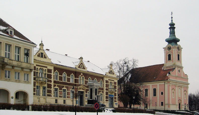
Oberwart
- municipality in Austria
Hiking in Oberwart
Oberwart, located in Burgenland, Austria, offers a variety of hiking opportunities that cater to different experience levels. The region is characterized by its rolling hills, vineyards, and picturesque landscapes, making it a great destination for outdoor enthusiasts....
- Country:
- Postal Code: 7400
- Local Dialing Code: 03352
- Licence Plate Code: OW
- Coordinates: 47° 17' 16" N, 16° 12' 11" E
- GPS tracks (wikiloc): [Link]
- AboveSeaLevel: 315 м m
- Area: 36.5 sq km
- Population: 7572
- Web site: [Link]
Neustift an der Lafnitz
- municipality in Austria
Hiking in Neustift an der Lafnitz
Neustift an der Lafnitz is a charming village located in the Burgenland region of Austria, known for its beautiful landscapes and tranquil natural surroundings. Hiking in this area can be a rewarding experience due to the scenic views, diverse terrain, and rich biodiversity....
- Country:
- Postal Code: 7423
- Local Dialing Code: 03338
- Licence Plate Code: OW
- Coordinates: 47° 22' 2" N, 16° 1' 41" E
- GPS tracks (wikiloc): [Link]
- AboveSeaLevel: 410 м m
- Area: 3.5 sq km
- Population: 793
- Web site: [Link]

Bad Tatzmannsdorf
- municipality in Austria
Hiking in Bad Tatzmannsdorf
Bad Tatzmannsdorf, located in Austria, is a charming destination known for its wellness facilities and scenic landscapes, making it a great base for hiking enthusiasts. The region is surrounded by the rolling hills of the Bucklige Welt, offering various trails that cater to different skill levels....
- Country:
- Postal Code: 7431
- Local Dialing Code: 03353
- Licence Plate Code: OW
- Coordinates: 47° 20' 4" N, 16° 13' 38" E
- GPS tracks (wikiloc): [Link]
- AboveSeaLevel: 182 м m
- Area: 11.61 sq km
- Population: 1554
- Web site: [Link]
Oberschützen
- municipality in Austria
Hiking in Oberschützen
Oberschützen, located in the Burgenland region of Austria, offers a lovely mix of natural beauty and serene hiking opportunities. Here are some highlights about hiking in this area:...
- Country:
- Postal Code: 7432
- Local Dialing Code: 03353
- Licence Plate Code: OW
- Coordinates: 47° 20' 59" N, 16° 12' 30" E
- GPS tracks (wikiloc): [Link]
- AboveSeaLevel: 355 м m
- Area: 44.39 sq km
- Population: 2429
- Web site: [Link]