Ore (Ore)

- commune in Haute-Garonne, France
- Country:

- Postal Code: 31510
- Coordinates: 42° 58' 31" N, 0° 39' 2" E


- GPS tracks (wikiloc): [Link]
- Area: 2.86 sq km
- Population: 108
- Wikipedia en: wiki(en)
- Wikipedia: wiki(fr)
- Wikidata storage: Wikidata: Q1428160
- Wikipedia Commons Category: [Link]
- Freebase ID: [/m/03nt51n]
- Freebase ID: [/m/03nt51n]
- GeoNames ID: Alt: [6431741]
- GeoNames ID: Alt: [6431741]
- SIREN number: [213104052]
- SIREN number: [213104052]
- BnF ID: [15255400j]
- BnF ID: [15255400j]
- INSEE municipality code: 31405
- INSEE municipality code: 31405
Shares border with regions:


Antichan-de-Frontignes
- commune in Haute-Garonne, France
- Country:
- Postal Code: 31510
- Coordinates: 42° 58' 23" N, 0° 39' 56" E
- GPS tracks (wikiloc): [Link]
- Area: 4.27 sq km
- Population: 98


Saléchan
- commune in Hautes-Pyrénées, France
- Country:
- Postal Code: 65370
- Coordinates: 42° 57' 21" N, 0° 37' 52" E
- GPS tracks (wikiloc): [Link]
- Area: 4.1 sq km
- Population: 261


Galié
- commune in Haute-Garonne, France
- Country:
- Postal Code: 31510
- Coordinates: 42° 59' 19" N, 0° 37' 58" E
- GPS tracks (wikiloc): [Link]
- AboveSeaLevel: 694.5 м m
- Area: 2.86 sq km
- Population: 86


Frontignan-de-Comminges
- commune in Haute-Garonne, France
- Country:
- Postal Code: 31510
- Coordinates: 42° 58' 16" N, 0° 39' 31" E
- GPS tracks (wikiloc): [Link]
- Area: 2.53 sq km
- Population: 72

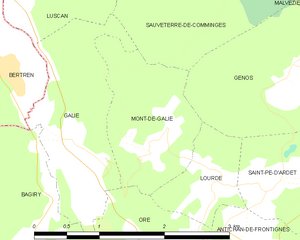
Mont-de-Galié
- commune in Haute-Garonne, France
- Country:
- Postal Code: 31510
- Coordinates: 42° 59' 21" N, 0° 38' 49" E
- GPS tracks (wikiloc): [Link]
- Area: 2.42 sq km
- Population: 40


Lourde
- commune in Haute-Garonne, France
- Country:
- Postal Code: 31510
- Coordinates: 42° 59' 3" N, 0° 39' 39" E
- GPS tracks (wikiloc): [Link]
- Area: 1.24 sq km
- Population: 91


Bagiry
- commune in Haute-Garonne, France
- Country:
- Postal Code: 31510
- Coordinates: 42° 58' 40" N, 0° 37' 33" E
- GPS tracks (wikiloc): [Link]
- Area: 2.78 sq km
- Population: 96

Sainte-Marie
- commune in Hautes-Pyrénées, France
- Country:
- Postal Code: 65370
- Coordinates: 42° 58' 22" N, 0° 37' 17" E
- GPS tracks (wikiloc): [Link]
- AboveSeaLevel: 450 м m
- Area: 0.28 sq km
- Population: 66


Fronsac
- commune in Haute-Garonne, France
- Country:
- Postal Code: 31440
- Coordinates: 42° 57' 8" N, 0° 38' 57" E
- GPS tracks (wikiloc): [Link]
- Area: 4.15 sq km
- Population: 207