Ortoncourt (Ortoncourt)

- commune in Vosges, France
- Country:

- Postal Code: 88700
- Coordinates: 48° 22' 0" N, 6° 30' 43" E


- GPS tracks (wikiloc): [Link]
- Area: 4.39 sq km
- Population: 92
- Wikipedia en: wiki(en)
- Wikipedia: wiki(fr)
- Wikidata storage: Wikidata: Q960079
- Wikipedia Commons Category: [Link]
- Freebase ID: [/m/03qgwkc]
- Freebase ID: [/m/03qgwkc]
- GeoNames ID: Alt: [6445671]
- GeoNames ID: Alt: [6445671]
- SIREN number: [218803385]
- SIREN number: [218803385]
- BnF ID: [15279262x]
- BnF ID: [15279262x]
- INSEE municipality code: 88338
- INSEE municipality code: 88338
Shares border with regions:

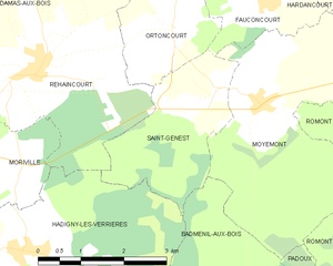
Saint-Genest
- commune in Vosges, France
- Country:
- Postal Code: 88700
- Coordinates: 48° 21' 16" N, 6° 31' 28" E
- GPS tracks (wikiloc): [Link]
- Area: 6.26 sq km
- Population: 132


Haillainville
- commune in Vosges, France
- Country:
- Postal Code: 88330
- Coordinates: 48° 23' 34" N, 6° 28' 55" E
- GPS tracks (wikiloc): [Link]
- Area: 12.26 sq km
- Population: 169


Fauconcourt
- commune in Vosges, France
- Country:
- Postal Code: 88700
- Coordinates: 48° 22' 23" N, 6° 32' 26" E
- GPS tracks (wikiloc): [Link]
- Area: 4.9 sq km
- Population: 125


Rehaincourt
- commune in Vosges, France
- Country:
- Postal Code: 88330
- Coordinates: 48° 21' 43" N, 6° 28' 9" E
- GPS tracks (wikiloc): [Link]
- Area: 15.22 sq km
- Population: 347