Oschiri (Oschiri)
%20-%202016.svg)
- comune in the Italian region of Sardinia
 Hiking in Oschiri
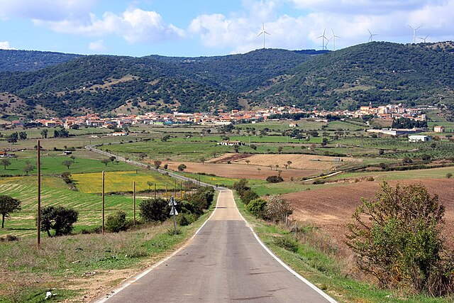
Oschiri is a picturesque town located in the province of Sassari in Sardinia, Italy. It's surrounded by breathtaking landscapes, making it a great destination for hiking enthusiasts. Here are some key points that can enhance your hiking experience in and around Oschiri:
Hiking Trails
-
Monte Nurgalze: This is a popular hike that offers stunning panoramic views of the region. The trail can be moderately challenging, so it's suitable for those with some hiking experience.
-
Lago di Coghinas: This lake is surrounded by trails that provide a fantastic mix of nature and scenic water views. Walking along the lakeside can be both relaxing and invigorating.
-
Foresta di Montimannu: A beautiful forest area with various trails that allow hikers to immerse themselves in Sardinian flora and fauna. This is a great spot for birdwatching and enjoying the natural silence.
-
Su Tzilleri: This is a lesser-known route that leads through ancient paths, providing a glimpse of local history and culture, including ancient stone churches.
Best Seasons for Hiking
- Spring (April to June): This is an ideal time due to mild temperatures, blooming wildflowers, and vibrant landscapes.
- Fall (September to November): Similar to spring, fall offers comfortable temperatures and beautiful fall foliage, making it perfect for hiking.
Hiking Tips
- Preparation: Always check the weather before heading out, and bring sufficient water, snacks, and appropriate gear (like sturdy hiking boots and a hat).
- Maps and Navigation: Familiarize yourself with the trails beforehand. Carry a physical map or a GPS device, as mobile service may be limited in remote areas.
- Respect Nature: Follow the Leave No Trace principles to minimize your impact on the beautiful environment.
Local Amenities
- Accommodation: Oschiri offers various accommodation options, from hotels to guesthouses, perfect for hiking enthusiasts looking to rest after a long day on the trails.
- Local Cuisine: Don’t miss trying local Sardinian dishes, which can be a rewarding way to recover after a day of hiking.
Oschiri's combination of natural beauty, historical significance, and welcoming atmosphere makes it a fantastic spot for hikers of all levels. Enjoy your outdoor adventures!
- Country:

- Postal Code: 07027
- Local Dialing Code: 079
- Licence Plate Code: SS
- Coordinates: 40° 43' 9" N, 9° 6' 5" E


- GPS tracks (wikiloc): [Link]
- AboveSeaLevel: 202 м m
- Area: 215.61 sq km
- Population: 3265
- Web site: http://www.comune.oschiri.ss.it/
- Wikipedia en: wiki(en)
- Wikipedia: wiki(it)
- Wikidata storage: Wikidata: Q340961
- Wikipedia Commons Category: [Link]
- Freebase ID: [/m/0gr9s8]
- GeoNames ID: Alt: [6539235]
- OSM relation ID: [40682]
- ISTAT ID: 090049
- Italian cadastre code: G153
Shares border with regions:


Tempio Pausania
- Italian comune
Hiking in Tempio Pausania
Tempio Pausania, located in the northern part of Sardinia, Italy, is surrounded by picturesque landscapes, making it an excellent destination for hiking enthusiasts. The area is characterized by its unique granite formations, lush forests, and a variety of trails suitable for different hiking levels....
- Country:
- Postal Code: 07029
- Local Dialing Code: 079
- Licence Plate Code: SS
- Coordinates: 40° 54' 5" N, 9° 6' 16" E
- GPS tracks (wikiloc): [Link]
- AboveSeaLevel: 566 м m
- Area: 210.82 sq km
- Population: 13973
- Web site: [Link]


Alà dei Sardi
- Italian comune
Hiking in Alà dei Sardi
Alà dei Sardi is a charming village located in the province of Olbia-Tempio in Sardinia, Italy. The region offers a variety of landscapes that make it an excellent location for hiking enthusiasts. Here are some highlights related to hiking in Alà dei Sardi:...
- Country:
- Postal Code: 07020
- Local Dialing Code: 079
- Licence Plate Code: SS
- Coordinates: 40° 39' 5" N, 9° 19' 45" E
- GPS tracks (wikiloc): [Link]
- AboveSeaLevel: 700 м m
- Area: 197.99 sq km
- Population: 1853
- Web site: [Link]


Berchidda
- Italian comune
Hiking in Berchidda
Berchidda is a beautiful village located in the province of Olbia-Tempio in Sardinia, Italy. Nestled in the northeastern part of the island, Berchidda is surrounded by stunning landscapes that make it a great destination for hiking enthusiasts. Here are some highlights of hiking in and around Berchidda:...
- Country:
- Postal Code: 07022
- Local Dialing Code: 079
- Licence Plate Code: SS
- Coordinates: 40° 47' 9" N, 9° 9' 57" E
- GPS tracks (wikiloc): [Link]
- AboveSeaLevel: 290 м m
- Area: 201.88 sq km
- Population: 2749
- Web site: [Link]


Buddusò
- Italian comune
Hiking in Buddusò
Buddusò, a small town in Sardinia, Italy, is surrounded by beautiful landscapes and offers varied hiking opportunities that cater to different skill levels. The region is part of the Gallura area, known for its scenic views, rich history, and unique geological formations. Here are some highlights for hiking in and around Buddusò:...
- Country:
- Postal Code: 07020
- Local Dialing Code: 079
- Licence Plate Code: SS
- Coordinates: 40° 34' 42" N, 9° 15' 30" E
- GPS tracks (wikiloc): [Link]
- AboveSeaLevel: 700 м m
- Area: 176.84 sq km
- Population: 3846
- Web site: [Link]


Ozieri
- Italian comune
Hiking in Ozieri
Ozieri, located in the province of Sassari on the island of Sardinia, Italy, offers a range of hiking opportunities thanks to its diverse landscapes, including hills, forests, and archaeological sites. Here’s an overview of what you can expect when hiking in and around Ozieri:...
- Country:
- Postal Code: 07014
- Local Dialing Code: 079
- Licence Plate Code: SS
- Coordinates: 40° 35' 6" N, 9° 0' 12" E
- GPS tracks (wikiloc): [Link]
- AboveSeaLevel: 490 м m
- Area: 252.13 sq km
- Population: 10575
- Web site: [Link]


Pattada
- Italian comune
Hiking in Pattada
Pattada is a mountainous area located in the Sassari province of Sardinia, Italy. Known for its rich natural beauty and diverse landscapes, it offers a variety of hiking opportunities for both beginners and experienced hikers. Here are some key features and tips for hiking in Pattada:...
- Country:
- Postal Code: 07016
- Local Dialing Code: 079
- Licence Plate Code: SS
- Coordinates: 40° 34' 56" N, 9° 6' 36" E
- GPS tracks (wikiloc): [Link]
- AboveSeaLevel: 778 м m
- Area: 164.88 sq km
- Population: 3048
- Web site: [Link]

Tula, Sardinia
- Italian comune
Hiking in Tula, Sardinia
Tula, located in the northern part of Sardinia, is a charming town surrounded by stunning natural landscapes, making it a great destination for hiking enthusiasts. The area is characterized by its rugged terrain, rolling hills, and diverse flora and fauna, offering a range of trails suitable for different skill levels. Here are some highlights of hiking in Tula:...
- Country:
- Postal Code: 07010
- Local Dialing Code: 079
- Licence Plate Code: SS
- Coordinates: 40° 43' 57" N, 8° 59' 5" E
- GPS tracks (wikiloc): [Link]
- AboveSeaLevel: 275 м m
- Area: 66.19 sq km
- Population: 1544
- Web site: [Link]