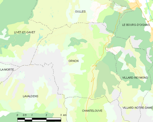
Oulles (Oulles)

- commune in Isère, France
 Hiking in Oulles
Oulles is a small, picturesque village located in the French Alps, known for its stunning natural beauty and excellent hiking opportunities. Situated in the Isère department, it offers a variety of trails suitable for different skill levels, making it a great destination for both novice and experienced hikers.
Key Hiking Trails:
-
Oulles Waterfall Trail:
- Difficulty: Easy to Moderate
- Length: Approximately 3 km
- Highlights: This trail takes you to a beautiful waterfall, where you can enjoy the sound of cascading water and the surrounding lush greenery. It's perfect for families and those looking for a short trek.
-
Via Ferrata de la Gorge d’Alands:
- Difficulty: Moderate to Hard
- Highlights: For adventurous hikers, this via ferrata combines hiking with rock climbing, featuring fixed cables and ladders. It's an exhilarating way to explore the cliffs and offers dramatic views of the gorge and surrounding mountains.
-
Col de Vence:
- Difficulty: Moderate
- Length: Around 10 km round trip
- Highlights: This trail leads to the Col de Vence pass, providing panoramic views of the surrounding alpine landscape. It’s a great option for a day hike with plenty of opportunities for photography and enjoying nature.
-
Tour du Pays de l'Oisans:
- Difficulty: Hard
- Highlights: For a more challenging adventure, consider exploring sections of the Tour du Pays de l'Oisans, a long-distance trail that showcases the stunning scenery of the Oisans region, including glaciers, ridges, and alpine meadows.
Best Time to Go:
- Summer (June to September): Provides the best weather conditions for hiking. The trails are typically clear of snow, and wildflowers are in bloom.
- Autumn (September to October): Offers beautiful autumn colors, though it's important to check the weather as conditions can become unpredictable.
Preparation and Safety:
- Always check weather conditions before heading out.
- Wear appropriate hiking shoes and bring a map or a GPS device.
- Carry enough water and snacks to stay hydrated and energized.
- Let someone know your hiking plans, especially if you’re going on a longer or more difficult trail.
Local Amenities:
Oulles offers limited amenities, so it's advisable to bring your own supplies. However, nearby towns may have shops and restaurants where you can refuel after your hike.
Hiking in Oulles provides a fantastic way to immerse yourself in the natural beauty of the French Alps, with trails that cater to all levels of experience. Enjoy your adventure!
- Country:

- Postal Code: 38520
- Coordinates: 45° 4' 27" N, 5° 58' 58" E


- GPS tracks (wikiloc): [Link]
- Area: 11.01 sq km
- Population: 9
- Web site: http://www.oulles.fr/
- Wikipedia en: wiki(en)
- Wikipedia: wiki(fr)
- Wikidata storage: Wikidata: Q1150796
- Wikipedia Commons Category: [Link]
- Freebase ID: [/m/03g_1k4]
- GeoNames ID: Alt: [6433272]
- SIREN number: [213802861]
- BnF ID: [15258098q]
- INSEE municipality code: 38286
Shares border with regions:

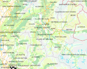
Ornon
- commune in Isère, France
Hiking in Ornon
Ornon is a lesser-known area that offers unique hiking opportunities, especially for those seeking a more tranquil outdoor experience. Located in the French Alps, the region is characterized by its stunning landscapes, dense forests, and diverse wildlife....
- Country:
- Postal Code: 38520
- Coordinates: 45° 2' 28" N, 5° 58' 40" E
- GPS tracks (wikiloc): [Link]
- Area: 11.6 sq km
- Population: 133
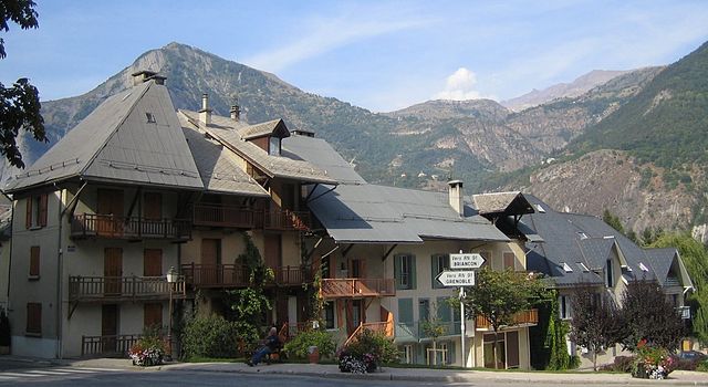
Le Bourg-d'Oisans
- commune in Isère, France
Hiking in Le Bourg-d'Oisans
Le Bourg-d'Oisans is a charming commune located in the French Alps, nestled between the Oisans mountain range and the breathtaking Ecrins National Park. It's an excellent base for those who enjoy hiking, as it offers a variety of trails suitable for all experience levels, from beginner to advanced....
- Country:
- Postal Code: 38520
- Coordinates: 45° 3' 19" N, 6° 1' 46" E
- GPS tracks (wikiloc): [Link]
- Area: 35.75 sq km
- Population: 3239
- Web site: [Link]


Livet-et-Gavet
- commune in Isère, France
Hiking in Livet-et-Gavet
Livet-et-Gavet, located in the Auvergne-Rhône-Alpes region of France, is a picturesque destination for hiking enthusiasts. This area is characterized by its stunning natural landscapes, including lush forests, rivers, and mountainous terrain. Here are some highlights and tips for hiking in Livet-et-Gavet:...
- Country:
- Postal Code: 38220
- Coordinates: 45° 5' 28" N, 5° 54' 9" E
- GPS tracks (wikiloc): [Link]
- Area: 46.54 sq km
- Population: 1296
- Web site: [Link]