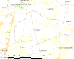
Ouville (Ouville)

- commune in Manche, France
- Country:

- Postal Code: 50210
- Coordinates: 49° 1' 10" N, 1° 21' 45" E


- GPS tracks (wikiloc): [Link]
- Area: 11.2 sq km
- Population: 449
- Wikipedia en: wiki(en)
- Wikipedia: wiki(fr)
- Wikidata storage: Wikidata: Q682818
- Wikipedia Commons Category: [Link]
- Freebase ID: [/m/03nxb33]
- Freebase ID: [/m/03nxb33]
- GeoNames ID: Alt: [6454218]
- GeoNames ID: Alt: [6454218]
- SIREN number: [215003898]
- SIREN number: [215003898]
- BnF ID: [15262363n]
- BnF ID: [15262363n]
- INSEE municipality code: 50389
- INSEE municipality code: 50389
Shares border with regions:


Belval
- commune in Manche, France
- Country:
- Postal Code: 50210
- Coordinates: 49° 2' 22" N, 1° 21' 49" E
- GPS tracks (wikiloc): [Link]
- Area: 5.72 sq km
- Population: 312


Savigny
- commune in Manche, France
- Country:
- Postal Code: 50210
- Coordinates: 49° 2' 59" N, 1° 20' 20" E
- GPS tracks (wikiloc): [Link]
- Area: 10.16 sq km
- Population: 441

Saussey
- commune in Manche, France
- Country:
- Postal Code: 50200
- Coordinates: 49° 0' 34" N, 1° 26' 0" E
- GPS tracks (wikiloc): [Link]
- Area: 8.89 sq km
- Population: 478
- Web site: [Link]


Saint-Denis-le-Vêtu
- commune in Manche, France
- Country:
- Postal Code: 50210
- Coordinates: 48° 59' 10" N, 1° 24' 11" E
- GPS tracks (wikiloc): [Link]
- Area: 14.08 sq km
- Population: 618


Montpinchon
- commune in Manche, France
- Country:
- Postal Code: 50210
- Coordinates: 49° 1' 20" N, 1° 18' 36" E
- GPS tracks (wikiloc): [Link]
- Area: 16.94 sq km
- Population: 546


Nicorps
- commune in Manche, France
- Country:
- Postal Code: 50200
- Coordinates: 49° 1' 37" N, 1° 25' 15" E
- GPS tracks (wikiloc): [Link]
- Area: 5.63 sq km
- Population: 418


Courcy
- commune in Manche, France
- Country:
- Postal Code: 50200
- Coordinates: 49° 2' 29" N, 1° 23' 35" E
- GPS tracks (wikiloc): [Link]
- Area: 11.45 sq km
- Population: 618