Ouzouer-le-Doyen (Ouzouer-le-Doyen)

- commune in Loir-et-Cher, France
- Country:

- Postal Code: 41160
- Coordinates: 47° 56' 30" N, 1° 20' 25" E


- GPS tracks (wikiloc): [Link]
- Area: 16.59 sq km
- Population: 245
- Wikipedia en: wiki(en)
- Wikipedia: wiki(fr)
- Wikidata storage: Wikidata: Q388876
- Wikipedia Commons Category: [Link]
- Freebase ID: [/m/03nw1tj]
- GeoNames ID: Alt: [2988906]
- SIREN number: [214101727]
- BnF ID: [15259446t]
- INSEE municipality code: 41172
Shares border with regions:


Brévainville
- commune in Loir-et-Cher, France
- Country:
- Postal Code: 41160
- Coordinates: 47° 57' 10" N, 1° 17' 4" E
- GPS tracks (wikiloc): [Link]
- Area: 16.16 sq km
- Population: 169

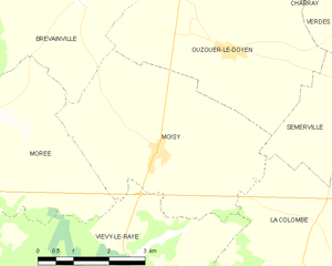
Moisy
- commune in Loir-et-Cher, France
- Country:
- Postal Code: 41160
- Coordinates: 47° 54' 54" N, 1° 18' 56" E
- GPS tracks (wikiloc): [Link]
- Area: 17.33 sq km
- Population: 353


Semerville
- former commune in Loir-et-Cher, France
- Country:
- Postal Code: 41160
- Coordinates: 47° 55' 57" N, 1° 22' 46" E
- GPS tracks (wikiloc): [Link]
- Area: 9.67 sq km
- Population: 102
Verdes
- former commune in Loir-et-Cher, France
- Country:
- Postal Code: 41240
- Coordinates: 47° 57' 29" N, 1° 25' 45" E
- GPS tracks (wikiloc): [Link]
- Area: 28.59 sq km
- Population: 462
Charray
- former commune in Eure-et-Loir, France
- Country:
- Postal Code: 28220
- Coordinates: 47° 58' 20" N, 1° 19' 35" E
- GPS tracks (wikiloc): [Link]
- Area: 10.98 sq km
- Population: 108