Péreuil (Péreuil)

- former commune in Charente, France
- Country:

- Postal Code: 16250
- Coordinates: 45° 28' 53" N, 0° 1' 21" E


- GPS tracks (wikiloc): [Link]
- Area: 17.18 sq km
- Population: 415
- Wikipedia en: wiki(en)
- Wikipedia: wiki(fr)
- Wikidata storage: Wikidata: Q831505
- Wikipedia Commons Category: [Link]
- Freebase ID: [/m/03mccm6]
- GeoNames ID: Alt: [2987996]
- INSEE municipality code: 16257
Shares border with regions:

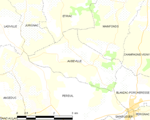
Aubeville
- former commune in Charente, France
- Country:
- Postal Code: 16250
- Coordinates: 45° 29' 55" N, 0° 0' 14" E
- GPS tracks (wikiloc): [Link]
- Area: 8.22 sq km
- Population: 140


Angeduc
- commune in Charente, France
- Country:
- Postal Code: 16300
- Coordinates: 45° 28' 29" N, 0° 3' 1" E
- GPS tracks (wikiloc): [Link]
- Area: 3.59 sq km
- Population: 130


Saint-Bonnet
- commune in Charente, France
- Country:
- Postal Code: 16300
- Coordinates: 45° 28' 42" N, 0° 5' 55" E
- GPS tracks (wikiloc): [Link]
- Area: 17.77 sq km
- Population: 398


Saint-Aulais-la-Chapelle
- commune in Charente, France
- Country:
- Postal Code: 16300
- Coordinates: 45° 26' 53" N, 0° 2' 59" E
- GPS tracks (wikiloc): [Link]
- Area: 14.84 sq km
- Population: 234

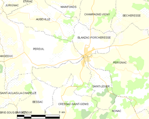
Blanzac-Porcheresse
- former commune in Charente, France
- Country:
- Postal Code: 16250
- Coordinates: 45° 29' 0" N, 0° 2' 0" E
- GPS tracks (wikiloc): [Link]
- AboveSeaLevel: 80 м m
- Area: 10.84 sq km
- Population: 773
- Web site: [Link]


Ladiville
- commune in Charente, France
- Country:
- Postal Code: 16120
- Coordinates: 45° 30' 54" N, 0° 3' 59" E
- GPS tracks (wikiloc): [Link]
- Area: 7.19 sq km
- Population: 113

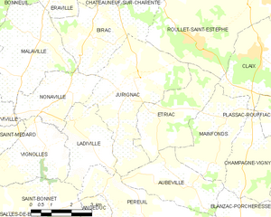
Jurignac
- former commune in Charente, France
- Country:
- Postal Code: 16250
- Coordinates: 45° 32' 1" N, 0° 2' 17" E
- GPS tracks (wikiloc): [Link]
- Area: 16 sq km
- Population: 617