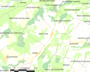
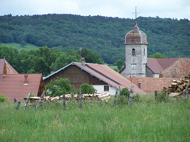
Passavant (Passavant)

- commune in Doubs, France
 Hiking in Passavant
Passavant is a charming village located in the Doubs department in the Bourgogne-Franche-Comté region of eastern France. The area is known for its scenic landscapes, ranging from rolling hills to lush forests and water bodies, making it an excellent destination for hiking enthusiasts.
Hiking Trails in Passavant:
-
Local Trails: Passavant has a network of local trails that offer various degrees of difficulty. These paths often weave through forests, farmland, and alongside streams, allowing hikers to immerse themselves in the natural beauty of the region.
-
Cultural Routes: Some trails may also lead to historical sites and churches, as Passavant is rich in history. Exploring these trails gives hikers an opportunity to appreciate both nature and local heritage.
-
Nearby National Parks: The nearby Doubs Valley and Jura Mountains provide more extensive hiking opportunities, with well-maintained trails ranging from easy walks to more challenging hikes. The Parc Naturel Régional du Haut-Jura is a short drive away and offers a stunning backdrop for outdoor adventures.
Tips for Hiking in Passavant:
-
Weather: Always check the weather conditions before heading out since the area can experience rapid changes in weather.
-
Footwear: Wear sturdy hiking boots to navigate varied terrain comfortably.
-
Hydration and Snacks: Carry enough water and snacks to keep your energy levels up during longer hikes.
-
Maps and Navigation: It’s advisable to have a physical map or a reliable GPS device, as some trails might not be well-marked.
-
Respect Nature: Follow Leave No Trace principles to preserve the natural beauty of the area for future generations.
Conclusion:
Hiking in and around Passavant, Doubs, offers a delightful experience for nature lovers and outdoor adventurers. Whether you’re looking for a relaxed stroll or a challenging hike, the natural beauty and tranquility of this region are sure to leave you with lasting memories.
- Country:

- Postal Code: 25360
- Coordinates: 47° 16' 29" N, 6° 23' 1" E


- GPS tracks (wikiloc): [Link]
- Area: 14.98 sq km
- Population: 229
- Wikipedia en: wiki(en)
- Wikipedia: wiki(fr)
- Wikidata storage: Wikidata: Q908610
- Wikipedia Commons Category: [Link]
- Freebase ID: [/m/03mhbxc]
- Freebase ID: [/m/03mhbxc]
- GeoNames ID: Alt: [6453860]
- GeoNames ID: Alt: [6453860]
- SIREN number: [212504468]
- SIREN number: [212504468]
- BnF ID: [152526727]
- BnF ID: [152526727]
- VIAF ID: Alt: [127462005]
- VIAF ID: Alt: [127462005]
- MusicBrainz area ID: [5c6cb7fa-d707-46e7-8ff3-eaab305aabd2]
- MusicBrainz area ID: [5c6cb7fa-d707-46e7-8ff3-eaab305aabd2]
- INSEE municipality code: 25446
- INSEE municipality code: 25446
Shares border with regions:


Adam-lès-Passavant
- commune in Doubs, France
Hiking in Adam-lès-Passavant
Adam-lès-Passavant, located in the Doubs department of the Bourgogne-Franche-Comté region in eastern France, offers a charming setting for hiking enthusiasts. The area is characterized by its stunning natural landscapes, including forests, rolling hills, and scenic viewpoints....
- Country:
- Postal Code: 25360
- Coordinates: 47° 17' 49" N, 6° 21' 42" E
- GPS tracks (wikiloc): [Link]
- Area: 9.59 sq km
- Population: 94


Courtetain-et-Salans
- commune in Doubs, France
Hiking in Courtetain-et-Salans
Courtetain-et-Salans is a charming commune located in the Bourgogne-Franche-Comté region of France, known for its picturesque landscapes and natural beauty. When hiking in this area, you'll find a variety of trails that showcase the rolling hills, lush forests, and serene countryside typical of this part of France....
- Country:
- Postal Code: 25530
- Coordinates: 47° 15' 25" N, 6° 25' 1" E
- GPS tracks (wikiloc): [Link]
- Area: 6.85 sq km
- Population: 84
- Web site: [Link]


Guillon-les-Bains
- commune in Doubs, France
Hiking in Guillon-les-Bains
Guillon-les-Bains is a charming location in France that offers a variety of hiking opportunities, perfect for nature enthusiasts and outdoor adventurers. Nestled in a picturesque setting, this region is well-known for its scenic landscapes, natural hot springs, and tranquil environment....
- Country:
- Postal Code: 25110
- Coordinates: 47° 19' 8" N, 6° 23' 37" E
- GPS tracks (wikiloc): [Link]
- Area: 4.72 sq km
- Population: 98


Vaudrivillers
- commune in Doubs, France
Hiking in Vaudrivillers
Vaudrivillers is a small commune located in the Jura region of France, known for its beautiful natural landscapes, rolling hills, and charming rural scenery. While it may not be a traditional hiking hotspot, there are opportunities for enjoyable walks and hikes in the surrounding areas....
- Country:
- Postal Code: 25360
- Coordinates: 47° 16' 53" N, 6° 25' 33" E
- GPS tracks (wikiloc): [Link]
- Area: 3.65 sq km
- Population: 90

Saint-Juan
- commune in Doubs, France
Hiking in Saint-Juan
Saint-Jean, depending on the region you are referring to, may provide a variety of hiking experiences. If you mean Saint-Jean-de-Maurienne in France or any other specific Saint-Jean locations, please clarify. However, here are some general aspects to consider when hiking in areas that might be called Saint-Jean:...
- Country:
- Postal Code: 25360
- Coordinates: 47° 17' 20" N, 6° 21' 23" E
- GPS tracks (wikiloc): [Link]
- Area: 12.09 sq km
- Population: 172

Orsans
- commune in Doubs, France
Hiking in Orsans
Orsans, located in the Doubs department of the Bourgogne-Franche-Comté region in eastern France, offers a serene and scenic environment for hiking enthusiasts. The area is characterized by its lush forests, rolling hills, and the picturesque landscapes of the Jura Mountains. Here are some highlights and tips for hiking in Orsans:...
- Country:
- Postal Code: 25530
- Coordinates: 47° 14' 51" N, 6° 23' 21" E
- GPS tracks (wikiloc): [Link]
- Area: 8.29 sq km
- Population: 164


Montivernage
- commune in Doubs, France
Hiking in Montivernage
Montivernage is a charming area popular among hikers due to its picturesque landscapes, diverse trails, and natural beauty. While I don't have specific details about Montivernage itself, I can provide general tips and insights that are applicable for hiking in similar mountainous or rural regions....
- Country:
- Postal Code: 25110
- Coordinates: 47° 19' 3" N, 6° 25' 38" E
- GPS tracks (wikiloc): [Link]
- Area: 3.34 sq km
- Population: 29