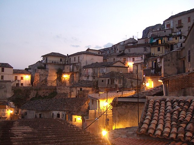
Pazzano (Pazzano)
.svg)
- Italian comune
 Hiking in Pazzano
Pazzano is a small village located in the Calabria region of southern Italy. It’s nestled in the Aspromonte National Park, which offers a variety of hiking trails that cater to different skill levels. Here’s an overview of what to expect when hiking in and around Pazzano:
Trails & Scenery
-
Aspromonte National Park: The park is known for its rugged terrain, dramatic landscapes, and lush forests. Trails vary from easy walks to challenging hikes, many offering breathtaking views of the surrounding mountains and valleys.
-
Historical Trails: Some hiking routes may lead you through remnants of ancient villages and historical sites, allowing you to experience the local culture and history alongside the natural beauty.
-
Flora and Fauna: The area is rich in biodiversity. You might encounter unique plant species, wildflowers, and various wildlife, including deer and a range of birds.
-
Stunning Views: Many trails provide viewpoints where hikers can admire the expansive vistas of the Calabria coastline and the rugged mountains.
Preparation
-
Physical Fitness: Choose trails that match your fitness level. While some paths may be relatively easy, others can demand physical stamina and navigation skills.
-
Gear: Wear appropriate hiking shoes and clothing. A good backpack with water, snacks, and a first-aid kit is essential. Trekking poles may also be helpful on steep or uneven terrain.
-
Maps and Guides: It’s advisable to have a trail map or use a hiking app, as some paths can be less marked. Local guides can provide valuable insights, increase your safety, and enhance your experience.
Best Time to Hike
Spring and early autumn are typically the best times for hiking in Pazzano, as temperatures are mild, and the weather is generally more stable. Summer can be hot, while winters can bring snow to higher elevations.
Additional Activities
If you’re in the area, consider exploring the local cuisine and experiencing the traditional culture of Calabria. Engaging with local communities can enrich your hiking experience.
Safety Tips
- Always inform someone about your hiking plans.
- Check the weather forecast before heading out.
- Stay on marked trails to protect the environment and ensure your safety.
Hiking in Pazzano can be an unforgettable experience for nature lovers and adventure seekers, filled with breathtaking scenery and a touch of Calabria's rich heritage.
- Country:

- Postal Code: 89040
- Local Dialing Code: 0964
- Licence Plate Code: RC
- Coordinates: 38° 28' 35" N, 16° 27' 6" E


- GPS tracks (wikiloc): [Link]
- AboveSeaLevel: 460 м m
- Area: 15.57 sq km
- Population: 529
- Web site: http://www.comune.pazzano.rc.it/
- Wikipedia en: wiki(en)
- Wikipedia: wiki(it)
- Wikidata storage: Wikidata: Q54634
- Wikipedia Commons Gallery: [Link]
- Wikipedia Commons Category: [Link]
- Wikipedia Commons Maps Category: [Link]
- Freebase ID: [/m/0ch6vf]
- GeoNames ID: Alt: [6537716]
- VIAF ID: Alt: [249436526]
- OSM relation ID: [39631]
- GND ID: Alt: [7617345-8]
- ISTAT ID: 080058
- Italian cadastre code: G394
Shares border with regions:


Bivongi
- Italian comune
Hiking in Bivongi
Bivongi is a charming village located in the Calabria region of southern Italy, nestled amidst the Aspromonte National Park. Its breathtaking scenery and rich natural beauty make it an excellent destination for hiking enthusiasts. Here are some key points to consider if you're planning a hiking adventure in Bivongi:...
- Country:
- Postal Code: 89040
- Local Dialing Code: 0964
- Licence Plate Code: RC
- Coordinates: 38° 29' 0" N, 16° 27' 0" E
- GPS tracks (wikiloc): [Link]
- AboveSeaLevel: 270 м m
- Area: 25.35 sq km
- Population: 1332
- Web site: [Link]


Caulonia
- Italian comune
Hiking in Caulonia
Caulonia, located in the Calabria region of southern Italy, offers a unique mix of coastal and inland hiking opportunities. While Caulonia itself may not be widely recognized as a major hiking destination, the surrounding area provides beautiful landscapes, scenic routes, and a variety of terrains for hiking enthusiasts....
- Country:
- Postal Code: 89041/40
- Local Dialing Code: 0964
- Licence Plate Code: RC
- Coordinates: 38° 23' 0" N, 16° 25' 0" E
- GPS tracks (wikiloc): [Link]
- AboveSeaLevel: 298 м m
- Area: 101.76 sq km
- Population: 7110
- Web site: [Link]


Placanica
- Italian comune
Hiking in Placanica
Placanica is a small town in Calabria, Italy, known for its stunning natural landscapes and diverse hiking opportunities. While it may not be as famous as some other hiking destinations, it offers a unique experience for those looking to explore the less-traveled paths of Southern Italy....
- Country:
- Postal Code: 89040
- Local Dialing Code: 0964
- Licence Plate Code: RC
- Coordinates: 38° 25' 0" N, 16° 27' 0" E
- GPS tracks (wikiloc): [Link]
- AboveSeaLevel: 250 м m
- Area: 29.51 sq km
- Population: 1150
- Web site: [Link]
Stignano
- Italian comune
Hiking in Stignano
Stignano is a picturesque location in Italy, nestled in the Calabria region. While it may not be as widely known as other hiking destinations, it offers beautiful landscapes, stunning views, and a chance to experience the natural beauty of southern Italy....
- Country:
- Postal Code: 89040
- Local Dialing Code: 0964
- Licence Plate Code: RC
- Coordinates: 38° 25' 1" N, 16° 28' 12" E
- GPS tracks (wikiloc): [Link]
- AboveSeaLevel: 343 м m
- Area: 17.77 sq km
- Population: 1367
- Web site: [Link]

Stilo
- Italian comune
Hiking in Stilo
Stilo, located in Calabria, Italy, is known for its beautiful landscapes, rich history, and diverse hiking opportunities. Here are some key points to consider if you're planning a hiking trip in Stilo:...
- Country:
- Postal Code: 89049
- Local Dialing Code: 0964
- Licence Plate Code: RC
- Coordinates: 38° 29' 0" N, 16° 28' 0" E
- GPS tracks (wikiloc): [Link]
- AboveSeaLevel: 386 м m
- Area: 78.11 sq km
- Population: 2573
- Web site: [Link]


Nardodipace
- Italian comune
Hiking in Nardodipace
Nardodipace is a small town located in the Calabria region of southern Italy, known for its stunning natural landscapes and rugged terrain, which provides excellent opportunities for hiking enthusiasts....
- Country:
- Postal Code: 88020
- Local Dialing Code: 0963
- Licence Plate Code: VV
- Coordinates: 38° 28' 0" N, 16° 20' 0" E
- GPS tracks (wikiloc): [Link]
- AboveSeaLevel: 1080 м m
- Area: 33.3 sq km
- Population: 1256
- Web site: [Link]