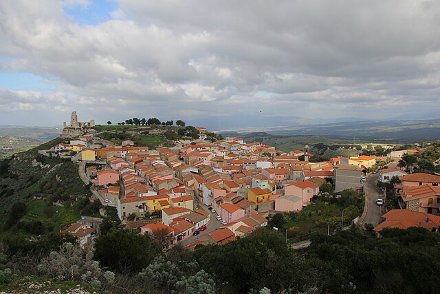
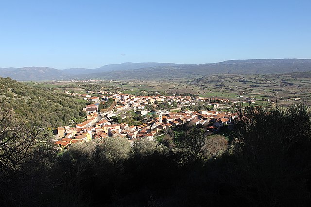
Perfugas (Perfugas)
%20-%202016.svg)
- Italian comune
 Hiking in Perfugas
Perfugas is a charming village located in the province of Sassari in Sardinia, Italy. Surrounded by beautiful landscapes, it offers various hiking opportunities that allow you to explore the region’s natural beauty and rich history. Here are some highlights of hiking in and around Perfugas:
1.
Perfugas is situated near the foothills of the Monte Ruiu, offering varied terrain that includes rolling hills, valleys, and rugged landscapes. The area is characterized by Mediterranean vegetation, including olive groves, vineyards, and wildflowers, making it a picturesque spot for hiking.
2.
While there may not be extensive formal hiking trails in Perfugas itself, there are several paths and roads that can be explored. Popular options around the region include:
- Monte Ruiu Trails: Explore trails leading up to Monte Ruiu, where you can enjoy panoramic views of the surrounding countryside.
- Valleys and Forests: Wander through the nearby forests and valleys, which are ideal for experiencing the local flora and fauna.
- Cultural Routes: Some routes may take you past historical sites and traditional Sardinian architecture, giving you a deeper insight into the area's culture.
3.
The area is home to various wildlife species, including birds and small mammals, which may be spotted during hikes. The diverse ecosystems provide opportunities for nature photography and observing the unique biodiversity of Sardinia.
4.
- Best Time to Hike: The best times for hiking around Perfugas are in the spring and fall when temperatures are milder. Summer can be hot, so early morning or late afternoon hikes are recommended.
- Preparation: Wear sturdy hiking shoes, carry water, and bring a map or GPS device, as trails may not be well-marked.
- Local Guidance: Consider reaching out to local hiking groups or tour guides if you want to explore more challenging or less-known routes.
5.
After your hike, you can explore the charming village of Perfugas itself, enjoy local cuisine, or venture to nearby attractions such as the archaeological sites of Anghelu Ruju and the beaches along the north coast of Sardinia.
Overall, hiking in Perfugas provides an excellent opportunity to experience the natural beauty, culture, and tranquility of Sardinia. Enjoy your adventure!
- Country:

- Postal Code: 07034
- Local Dialing Code: 079
- Licence Plate Code: SS
- Coordinates: 40° 49' 56" N, 8° 53' 4" E


- GPS tracks (wikiloc): [Link]
- AboveSeaLevel: 90 м m
- Area: 60.88 sq km
- Population: 2384
- Web site: http://www.comune.perfugas.ss.it
- Wikipedia en: wiki(en)
- Wikipedia: wiki(it)
- Wikidata storage: Wikidata: Q391241
- Wikipedia Commons Category: [Link]
- Freebase ID: [/m/0gqtmr]
- GeoNames ID: Alt: [6537836]
- VIAF ID: Alt: [129355148]
- OSM relation ID: [40772]
- WOEID: [720154]
- TGN ID: [7003634]
- ISTAT ID: 090056
- Italian cadastre code: G450
Shares border with regions:


Tempio Pausania
- Italian comune
Hiking in Tempio Pausania
Tempio Pausania, located in the northern part of Sardinia, Italy, is surrounded by picturesque landscapes, making it an excellent destination for hiking enthusiasts. The area is characterized by its unique granite formations, lush forests, and a variety of trails suitable for different hiking levels....
- Country:
- Postal Code: 07029
- Local Dialing Code: 079
- Licence Plate Code: SS
- Coordinates: 40° 54' 5" N, 9° 6' 16" E
- GPS tracks (wikiloc): [Link]
- AboveSeaLevel: 566 м m
- Area: 210.82 sq km
- Population: 13973
- Web site: [Link]


Bortigiadas
- Italian comune
Hiking in Bortigiadas
Bortigiadas is a small town located in the northern part of Sardinia, Italy. It's surrounded by stunning natural landscapes, including mountains, forests, and the beautiful countryside, making it an excellent destination for hiking enthusiasts. Here are some highlights and tips for hiking in this area:...
- Country:
- Postal Code: 07030
- Local Dialing Code: 079
- Licence Plate Code: SS
- Coordinates: 40° 53' 30" N, 9° 2' 34" E
- GPS tracks (wikiloc): [Link]
- AboveSeaLevel: 476 м m
- Area: 75.9 sq km
- Population: 759
- Web site: [Link]


Bulzi
- Italian comune
Hiking in Bulzi
Bulzi is a small village located in the province of Sassari in Sardinia, Italy. While it may not be as well-known as some other hiking destinations, the surrounding areas offer beautiful landscapes and opportunities for outdoor activities. Here are some details to consider if you're thinking about hiking in and around Bulzi:...
- Country:
- Postal Code: 07030
- Local Dialing Code: 079
- Licence Plate Code: SS
- Coordinates: 40° 50' 49" N, 8° 49' 49" E
- GPS tracks (wikiloc): [Link]
- AboveSeaLevel: 250 м m
- Area: 21.67 sq km
- Population: 507
- Web site: [Link]

Chiaramonti
- Italian comune
Hiking in Chiaramonti
Chiaramonti is a quaint town located in the northern part of Sardinia, Italy, surrounded by picturesque landscapes and a rich natural environment. The region offers various hiking opportunities that allow you to explore its unique features, including lush forests, rolling hills, and diverse flora and fauna....
- Country:
- Postal Code: 07030
- Local Dialing Code: 079
- Licence Plate Code: SS
- Coordinates: 40° 44' 58" N, 8° 49' 7" E
- GPS tracks (wikiloc): [Link]
- AboveSeaLevel: 400 м m
- Area: 98.61 sq km
- Population: 1623
- Web site: [Link]


Erula
- Italian comune
Hiking in Erula
Erula, a charming town located in Sardinia, Italy, offers some beautiful hiking opportunities amidst its stunning landscapes, historical sites, and rich natural environment. Here are some key aspects to consider for hiking in and around Erula:...
- Country:
- Postal Code: 07030
- Local Dialing Code: 079
- Licence Plate Code: SS
- Coordinates: 40° 47' 32" N, 8° 56' 38" E
- GPS tracks (wikiloc): [Link]
- AboveSeaLevel: 457 м m
- Area: 39.31 sq km
- Population: 733
- Web site: [Link]

Laerru
- Italian comune
Hiking in Laerru
Laerru is a small town located in the province of Sassari in northern Sardinia, Italy. While it may not be as widely recognized as other hiking destinations in Sardinia, it offers opportunities for outdoor enthusiasts to explore the natural beauty of the region, including hills, valleys, and traditional landscapes....
- Country:
- Postal Code: 07030
- Local Dialing Code: 079
- Licence Plate Code: SS
- Coordinates: 40° 49' 2" N, 8° 50' 7" E
- GPS tracks (wikiloc): [Link]
- AboveSeaLevel: 165 м m
- Area: 19.85 sq km
- Population: 903
- Web site: [Link]


Martis
- Italian comune
Hiking in Martis
Martis Valley, located in the Sierra Nevada region of California, is a beautiful destination known for its diverse landscapes, rich wildlife, and stunning views. Here’s an overview of what to expect when hiking in this area:...
- Country:
- Postal Code: 07030
- Local Dialing Code: 079
- Licence Plate Code: SS
- Coordinates: 40° 46' 42" N, 8° 48' 31" E
- GPS tracks (wikiloc): [Link]
- AboveSeaLevel: 295 м m
- Area: 22.96 sq km
- Population: 498
- Web site: [Link]


Santa Maria Coghinas
- Italian comune
Hiking in Santa Maria Coghinas
Santa Maria Coghinas is a charming village located in the region of Sardinia, Italy. It’s surrounded by beautiful landscapes, including rolling hills, natural springs, and the Coghinas River, which offer excellent opportunities for hiking and outdoor activities....
- Country:
- Postal Code: 07030
- Local Dialing Code: 079
- Licence Plate Code: SS
- Coordinates: 40° 54' 14" N, 8° 52' 6" E
- GPS tracks (wikiloc): [Link]
- AboveSeaLevel: 21 м m
- Area: 22.97 sq km
- Population: 1391
- Web site: [Link]