Pernersdorf (Pernersdorf)
- municipality in Austria
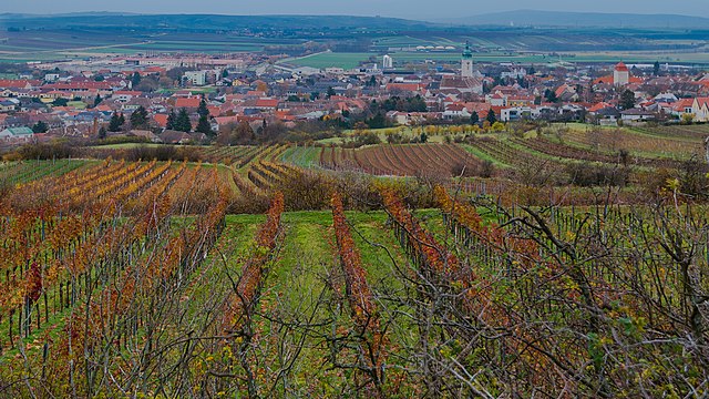
 Hiking in Pernersdorf
Pernersdorf, located in the northeastern part of Austria, offers a tranquil hiking experience with its picturesque landscapes and serene countryside. While it's less known than some of Austria's popular hiking destinations, it presents a charming opportunity for outdoor enthusiasts who appreciate less crowded trails.
Hiking Trails
Nearby, you can find several trails that allow you to enjoy the natural beauty of the region. Some trails may lead you through lush forests, open fields, and along riverbanks. You can often find paths that vary in difficulty, making it suitable for both beginners and experienced hikers.
Nature and Scenery
The surrounding areas feature rolling hills, vineyards, and farmlands, which contribute to stunning scenic views, especially during the fall when the foliage changes color. Wildlife enthusiasts may also appreciate the chance to spot local fauna along the trails.
Local Attractions
While hiking, you might find small villages with local culture, traditional Austrian cuisine, and wine tasting opportunities. Exploring local vineyards can be a great addition to your hiking experience.
Tips for Hiking in Pernersdorf
- Check Trail Information: Always check local maps and trail conditions, as some paths may be more challenging than they appear.
- Dress Appropriately: Weather can change quickly, so wear layers and appropriate hiking gear.
- Stay Hydrated and Energized: Carry enough water and snacks to maintain your energy levels throughout the hike.
- Respect Nature: Follow Leave No Trace principles to preserve the natural beauty of the area.
- Explore Local Culture: Take time to enjoy the local communities and their traditions during your hiking trip.
Overall, hiking in Pernersdorf can be a delightful way to connect with nature and enjoy Austria's charming countryside away from the hustle and bustle of more populous tourist areas.
- Country:

- Postal Code: 2052
- Local Dialing Code: 02944
- Licence Plate Code: HL
- Coordinates: 48° 42' 0" N, 16° 1' 0" E


- GPS tracks (wikiloc): [Link]
- AboveSeaLevel: 214 м m
- Area: 25.81 sq km
- Population: 1022
- Web site: http://www.pernersdorf.gv.at
- Wikipedia en: wiki(en)
- Wikipedia: wiki(de)
- Wikidata storage: Wikidata: Q676956
- Wikipedia Commons Category: [Link]
- Freebase ID: [/m/02qx70s]
- GeoNames ID: Alt: [2769074]
- VIAF ID: Alt: [244285736]
- Austrian municipality key: [31033]
Shares border with regions:
Retz
- town in the district of Hollabrunn in Lower Austria, Austria
Hiking in Retz
Retz, located in the Lower Austria region, is a charming town known for its scenic landscapes, historical architecture, and outdoor recreational opportunities. Hiking around Retz offers a variety of trails that cater to different skill levels, making it a great destination for both novice and experienced hikers....
- Country:
- Postal Code: 2070
- Local Dialing Code: 02942
- Licence Plate Code: HL
- Coordinates: 48° 45' 22" N, 15° 57' 8" E
- GPS tracks (wikiloc): [Link]
- AboveSeaLevel: 252 м m
- Area: 45.01 sq km
- Population: 4249
- Web site: [Link]

Zellerndorf
- municipality in Austria
Hiking in Zellerndorf
Zellerndorf, located in the scenic wine region of Lower Austria, offers a beautiful backdrop for hiking enthusiasts. The area is characterized by rolling hills, vineyards, and picturesque landscapes, making it ideal for both moderate day hikes and leisurely strolls....
- Country:
- Postal Code: 2051
- Local Dialing Code: 02945
- Licence Plate Code: HL
- Coordinates: 48° 42' 0" N, 15° 57' 0" E
- GPS tracks (wikiloc): [Link]
- AboveSeaLevel: 230 м m
- Area: 41.12 sq km
- Population: 2432
- Web site: [Link]

Guntersdorf
- municipality in Austria
Hiking in Guntersdorf
Guntersdorf is a charming village located in Austria, nestled in the scenic landscape of Lower Austria. While Guntersdorf itself is small, the surrounding area offers beautiful hiking opportunities that allow you to explore nature, enjoy the countryside, and soak in the tranquil atmosphere....
- Country:
- Postal Code: 2042
- Local Dialing Code: 02951
- Licence Plate Code: HL
- Coordinates: 48° 39' 0" N, 16° 3' 0" E
- GPS tracks (wikiloc): [Link]
- AboveSeaLevel: 246 м m
- Area: 28.41 sq km
- Population: 1145
- Web site: [Link]

Retzbach
- municipality in Austria
Hiking in Retzbach
Retzbach, located in Bavaria, Germany, is a charming small town that offers a variety of hiking opportunities in the surrounding area. It is situated near the picturesque Main River Valley and is part of the Franconian Wine Region, which adds to the scenic beauty of the hikes. Here are some key points to consider when hiking in and around Retzbach:...
- Country:
- Local Dialing Code: 02942
- Licence Plate Code: HL
- Coordinates: 48° 46' 0" N, 15° 59' 0" E
- GPS tracks (wikiloc): [Link]
- AboveSeaLevel: 243 м m
- Area: 18.14 sq km
- Population: 1002
- Web site: [Link]

Haugsdorf
- municipality in Austria
Hiking in Haugsdorf
Haugsdorf is a picturesque village located in the Weinviertel region of Lower Austria, renowned for its scenic landscapes and the surrounding natural beauty that makes it an excellent destination for hiking enthusiasts. Here are some aspects to consider when hiking in and around Haugsdorf:...
- Country:
- Postal Code: 2054
- Local Dialing Code: 02944
- Licence Plate Code: HL
- Coordinates: 48° 42' 0" N, 16° 4' 0" E
- GPS tracks (wikiloc): [Link]
- AboveSeaLevel: 204 м m
- Area: 21.23 sq km
- Population: 1548
- Web site: [Link]