Pescantina (Pescantina)
- Italian comune
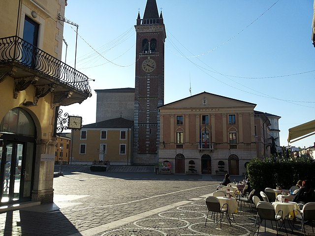
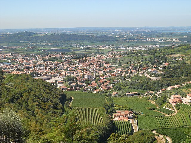
Pescantina is a charming village located in the Veneto region of Italy, just a few kilometers from Verona and close to the scenic shores of Lake Garda. The area surrounding Pescantina offers various hiking opportunities, characterized by picturesque landscapes, vineyards, and scenic trails.
Hiking Trails
-
Valpolicella Region: Pescantina is situated at the edge of the Valpolicella wine region, renowned for its rolling hills and beautiful vineyards. Numerous trails weave through the vineyards, offering a chance to experience local wine culture and stunning views.
-
Monte Majo: A popular hiking destination near Pescantina is Monte Majo. There are several trails leading to the summit, which provide panoramic views of the Valpolicella valley and Lake Garda. The hike can vary in difficulty, making it suitable for both beginners and experienced hikers.
-
Cycle Paths: While not traditional hiking, the area also has well-marked cycling paths that allow you to combine cycling with walking, providing a unique way to explore the natural beauty of the region.
-
Natural Reserves and Parks: Nearby natural parks, such as the Natural Park of Monte Baldo, offer extensive hiking opportunities, ranging from easy walks to more challenging climbs. The diverse flora and fauna make these trails particularly rewarding.
Tips for Hiking in Pescantina
- Check Weather Conditions: Always check the weather before heading out, as conditions can change quickly in this region.
- Stay Hydrated: Carry enough water, especially during warmer months, as trails can sometimes be exposed to the sun.
- Footwear: Wear sturdy hiking shoes to handle varied terrain comfortably.
- Local Maps: Consider obtaining a local map or using a hiking app to navigate the trails effectively.
- Respect Nature: Follow Leave No Trace principles to help preserve the beautiful landscapes.
Getting There
Pescantina is accessible by car, and it is also connected to Verona by public transport, making it easy for those staying in the city to enjoy a day of hiking.
Conclusion
Hiking in and around Pescantina allows you to immerse yourself in the natural beauty and rich culture of the Veneto region. Whether you are strolling through vineyards or climbing to breathtaking viewpoints, there are plenty of adventures to enjoy.
- Country:

- Postal Code: 37026
- Local Dialing Code: 045
- Licence Plate Code: VR
- Coordinates: 45° 29' 0" N, 10° 52' 0" E


- GPS tracks (wikiloc): [Link]
- AboveSeaLevel: 80 м m
- Area: 19.73 sq km
- Population: 17236
- Web site: http://www.comune.pescantina.vr.it/
- Wikipedia en: wiki(en)
- Wikipedia: wiki(it)
- Wikidata storage: Wikidata: Q48107
- Wikipedia Commons Category: [Link]
- Freebase ID: [/m/0gb2mm]
- GeoNames ID: Alt: [6540978]
- VIAF ID: Alt: [235707718]
- OSM relation ID: [45114]
- WOEID: [720193]
- TGN ID: [1045932]
- UN/LOCODE: [ITPNC]
- ISTAT ID: 023058
- Italian cadastre code: G481
Shares border with regions:


Verona
- city in Veneto, northern Italy
Hiking in Verona offers a delightful mix of stunning landscapes, historical sites, and a touch of Italian culture. While Verona is more famous for its rich history, including Juliet's balcony and impressive Roman architecture, it is also surrounded by beautiful natural areas perfect for hiking enthusiasts....
- Country:

- Postal Code: 37121–37142; 37100
- Local Dialing Code: 045
- Licence Plate Code: VR
- Coordinates: 45° 26' 17" N, 10° 59' 37" E


- GPS tracks (wikiloc): [Link]
- AboveSeaLevel: 59 м m
- Area: 198.92 sq km
- Population: 252520
- Web site: [Link]


Bussolengo
- Italian comune
Bussolengo is a charming town located in the Veneto region of northern Italy, near the beautiful Lake Garda. While Bussolengo itself is not a major hiking destination, it is strategically positioned near several hiking trails and natural parks that offer stunning views and diverse landscapes....
- Country:

- Postal Code: 37012; 37010
- Local Dialing Code: 045
- Licence Plate Code: VR
- Coordinates: 45° 28' 0" N, 10° 51' 0" E


- GPS tracks (wikiloc): [Link]
- AboveSeaLevel: 127 м m
- Area: 24.23 sq km
- Population: 19483
- Web site: [Link]

Sant'Ambrogio di Valpolicella
- Italian comune
 Hiking in Sant'Ambrogio di Valpolicella
Sant'Ambrogio di Valpolicella is a picturesque commune located in the Veneto region of Italy, known for its stunning landscapes, vineyards, and hiking trails that traverse the hills and valleys of the Valpolicella wine region. Here are some highlights and tips for hiking in this area:...
- Country:

- Postal Code: 37015
- Local Dialing Code: 045
- Licence Plate Code: VR
- Coordinates: 45° 31' 0" N, 10° 50' 0" E


- GPS tracks (wikiloc): [Link]
- AboveSeaLevel: 174 м m
- Area: 23.5 sq km
- Population: 11818
- Web site: [Link]


San Pietro in Cariano
- Italian comune
 Hiking in San Pietro in Cariano
San Pietro in Cariano is a charming town located in the province of Verona, in the Veneto region of Italy. Nestled amidst the picturesque hills of the Valpolicella wine region, it offers various hiking opportunities with stunning views of vineyards, olive groves, and the surrounding countryside....
- Country:

- Postal Code: 37029
- Local Dialing Code: 045
- Licence Plate Code: VR
- Coordinates: 45° 31' 0" N, 10° 53' 0" E


- GPS tracks (wikiloc): [Link]
- AboveSeaLevel: 151 м m
- Area: 20.24 sq km
- Population: 12930
- Web site: [Link]


Pastrengo
- Italian comune
Pastrengo, located in the Veneto region of Italy near Lake Garda, offers a variety of hiking opportunities. The area features beautiful landscapes, including rolling hills, vineyards, and historical sites, making it an excellent destination for hikers of all experience levels....
- Country:

- Postal Code: 37010
- Local Dialing Code: 045
- Licence Plate Code: VR
- Coordinates: 45° 30' 0" N, 10° 48' 0" E


- GPS tracks (wikiloc): [Link]
- AboveSeaLevel: 192 м m
- Area: 9 sq km
- Population: 3092
- Web site: [Link]
