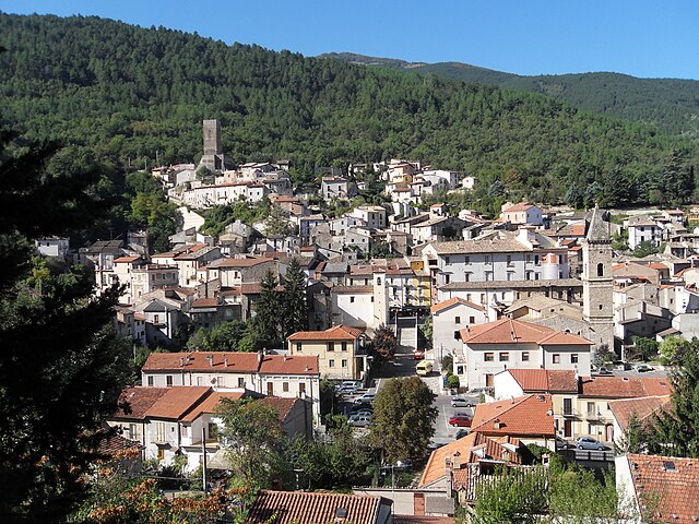
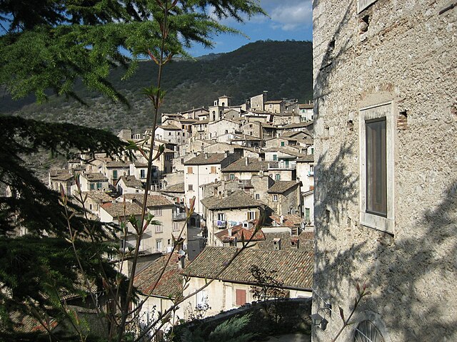
Pettorano sul Gizio (Pettorano sul Gizio)
.svg)
- Italian comune
 Hiking in Pettorano sul Gizio
Pettorano sul Gizio is a charming village located in the province of L'Aquila in the Abruzzo region of Italy. Surrounded by the beautiful Apennine mountains, it offers numerous hiking opportunities, showcasing stunning landscapes, rich biodiversity, and fascinating historical sites.
Hiking Trails
-
Pettorano sul Gizio to the Gorges of the Gizio River: This hike takes you through lush forests and offers breathtaking views of the river. The trail is relatively easy and suitable for families.
-
Path of the Ancient Flows: This route follows the historical pathways used by locals. It’s an opportunity to explore the area’s cultural heritage while enjoying the natural scenery. The trail features ancient stone bridges and ruins along the way.
-
Mezzi D'Abruzzo: An intermediate hike that leads you through picturesque landscapes, offering panoramic views of the surrounding mountains and valleys.
-
The Trail to Monte Genzana: For those seeking a more challenging hike, this trail leads to Monte Genzana, providing stunning views from the summit. It's advisable to have good walking shoes and sufficient water, as this trail can be steep in sections.
Flora and Fauna
The area around Pettorano sul Gizio is rich in biodiversity, with various species of flora and fauna. Keep an eye out for local wildlife, such as deer, foxes, and a variety of birds. The trails are often lined with wildflowers, especially in spring.
Best Time to Hike
The ideal time for hiking around Pettorano sul Gizio is during the spring and autumn months when the weather is mild and the landscapes are vibrant. Summer can be hot but also offers a different experience with lush greenery. Winter hiking is also possible, but be prepared for snow and colder temperatures.
Local Tips
- Always check the weather forecast before heading out.
- Bring enough water and snacks, especially for longer hikes.
- Ensure you have appropriate gear such as sturdy shoes, and consider trekking poles for more challenging trails.
- Respect the local environment and wildlife; stick to marked trails and carry out any waste.
Conclusion
Hiking in Pettorano sul Gizio provides a perfect blend of natural beauty, cultural heritage, and outdoor adventure. Whether you are a novice or an experienced hiker, there are trails suited for every level of experience, making it an excellent destination for nature lovers and outdoor enthusiasts.
- Country:

- Postal Code: 67034
- Local Dialing Code: 0864
- Licence Plate Code: AQ
- Coordinates: 41° 58' 32" N, 13° 57' 35" E


- GPS tracks (wikiloc): [Link]
- AboveSeaLevel: 625 м m
- Area: 62.85 sq km
- Population: 1414
- Web site: http://www.comune.pettorano.aq.it/
- Wikipedia en: wiki(en)
- Wikipedia: wiki(it)
- Wikidata storage: Wikidata: Q50124
- Wikipedia Commons Category: [Link]
- Freebase ID: [/m/0fg7gc]
- GeoNames ID: Alt: [6541204]
- VIAF ID: Alt: [236548189]
- OSM relation ID: [41668]
- WOEID: [720262]
- Digital Atlas of the Roman Empire ID: [29129]
- Google Maps Customer ID: [15322641296203648229]
- ISTAT ID: 066071
- Italian cadastre code: G524
Shares border with regions:


Cansano
- Italian comune
Hiking in Cansano
Cansano is a quaint village situated in the Abruzzo region of Italy, known for its picturesque landscapes and access to a variety of hiking trails. The area is characterized by rolling hills, lush forests, and stunning mountain views, making it a fantastic destination for outdoor enthusiasts....
- Country:
- Postal Code: 67030
- Local Dialing Code: 0864
- Licence Plate Code: AQ
- Coordinates: 42° 0' 19" N, 14° 0' 46" E
- GPS tracks (wikiloc): [Link]
- AboveSeaLevel: 835 м m
- Area: 37.7 sq km
- Population: 244
- Web site: [Link]

Introdacqua
- Italian comune
Hiking in Introdacqua
Introdacqua is a charming village located in the Abruzzo region of Italy, known for its stunning natural landscapes and picturesque views. Hiking in this area offers a variety of trails that cater to different skill levels. Here are some highlights and tips for hiking around Introdacqua:...
- Country:
- Postal Code: 67030
- Local Dialing Code: 0864
- Licence Plate Code: AQ
- Coordinates: 42° 0' 30" N, 13° 53' 57" E
- GPS tracks (wikiloc): [Link]
- AboveSeaLevel: 642 м m
- Area: 37.11 sq km
- Population: 2101
- Web site: [Link]


Pescocostanzo
- Italian comune
Hiking in Pescocostanzo
Pescocostanzo is a charming village located in the Abruzzo region of Italy, nestled in the Apennine Mountains. It is a fantastic destination for hikers, offering a mix of stunning landscapes, historical sites, and a range of trails suitable for different skill levels....
- Country:
- Postal Code: 67033
- Local Dialing Code: 0864
- Licence Plate Code: AQ
- Coordinates: 41° 53' 14" N, 14° 3' 59" E
- GPS tracks (wikiloc): [Link]
- AboveSeaLevel: 1395 м m
- Area: 55.06 sq km
- Population: 1090
- Web site: [Link]


Rocca Pia
- Italian comune
Hiking in Rocca Pia
Rocca Pia is a picturesque village located in the Abruzzo region of Italy, surrounded by beautiful landscapes, mountains, and natural parks. It's a great destination for hiking enthusiasts, offering a variety of trails that cater to different skill levels....
- Country:
- Postal Code: 67030
- Local Dialing Code: 0864
- Licence Plate Code: AQ
- Coordinates: 41° 56' 4" N, 13° 58' 40" E
- GPS tracks (wikiloc): [Link]
- AboveSeaLevel: 1181 м m
- Area: 44.96 sq km
- Population: 176
- Web site: [Link]

Scanno, Abruzzo
- Italian comune
Hiking in Scanno, Abruzzo
Scanno, located in the Abruzzo region of Italy, is a beautiful destination for hiking enthusiasts. Nestled in the heart of the Apennine Mountains, this charming town is surrounded by stunning landscapes, including picturesque lakes, rolling hills, and dense forests. Here are some details about hiking in the area:...
- Country:
- Postal Code: 67038
- Local Dialing Code: 0864
- Licence Plate Code: AQ
- Coordinates: 41° 54' 10" N, 13° 52' 48" E
- GPS tracks (wikiloc): [Link]
- AboveSeaLevel: 1050 м m
- Area: 134.68 sq km
- Population: 1780
- Web site: [Link]


Sulmona
- Italian comune
Hiking in Sulmona
Sulmona, located in the Abruzzo region of Italy, is renowned for its stunning landscapes and rich cultural heritage, making it a fantastic destination for hiking enthusiasts. The surrounding area offers a diverse range of trails, from gentle walks to challenging hikes, many of which provide breathtaking views of the Apennine Mountains and the beautiful countryside....
- Country:
- Postal Code: 67039
- Local Dialing Code: 0864
- Licence Plate Code: AQ
- Coordinates: 42° 2' 53" N, 13° 55' 34" E
- GPS tracks (wikiloc): [Link]
- AboveSeaLevel: 405 м m
- Area: 58.33 sq km
- Population: 24173
- Web site: [Link]