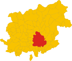
Pietrelcina (Pietrelcina)
- Italian comune
Pietrelcina, a small town in the Campania region of Italy, is not only known for its rich history and cultural significance but also for its beautiful natural landscapes, making it an excellent destination for hiking enthusiasts.
Hiking Trails
-
Local Trails: The surrounding countryside features various trails that wind through picturesque landscapes, including hills, olive groves, and vineyards. Many trails are relatively easy, making them suitable for beginners and families.
-
Regional Parks: Nearby, you can explore areas such as the Parco Regionale del Taburno-Camposauro, which offers more challenging hikes with stunning views of the Apennine mountains. The park is home to lush forests, diverse wildlife, and breathtaking panoramas, making it a great spot for experienced hikers.
-
Religious Pilgrimages: Pietrelcina is famously associated with Saint Pio of Pietrelcina (Padre Pio), and there are several hiking routes that connect to religious sites, offering both spiritual reflection and natural beauty.
What to Bring
- Footwear: Sturdy hiking boots or shoes are essential for navigating varying terrain.
- Clothing: Dress in layers to accommodate changes in weather. A lightweight, breathable outer layer is recommended.
- Water and Snacks: Always carry enough water and some snacks, especially on longer hikes.
- Map or GPS Device: While many trails are well-marked, having a map or GPS can help ensure you stay on track.
Best Time to Hike
- Spring and Fall: These seasons offer the best weather for hiking, with mild temperatures and blooming wildflowers in spring, or beautiful fall foliage later in the year.
- Summer: If hiking in summer, be prepared for higher temperatures; an early morning start is recommended to avoid the heat of the day.
Safety Tips
- Always inform someone of your hiking plans and expected return time.
- Check weather conditions before setting out.
- Consider hiking with a buddy, especially on more remote trails.
Local Attractions
After hiking, take time to explore Pietrelcina's historical sites, including the church dedicated to Padre Pio and the quaint town center, where you can enjoy local cuisine and the charming Italian atmosphere.
Overall, hiking in Pietrelcina allows you to enjoy the stunning natural beauty of the region while immersing yourself in its rich cultural heritage.
- Country:

- Postal Code: 82020
- Local Dialing Code: 0824
- Licence Plate Code: BN
- Coordinates: 41° 12' 0" N, 14° 51' 0" E


- GPS tracks (wikiloc): [Link]
- AboveSeaLevel: 350 м m
- Area: 28.25 sq km
- Population: 3094
- Web site: http://www.pietrelcina.com
- Wikipedia en: wiki(en)
- Wikipedia: wiki(it)
- Wikidata storage: Wikidata: Q55949
- Wikipedia Commons Gallery: [Link]
- Wikipedia Commons Category: [Link]
- Freebase ID: [/m/062m7z]
- GeoNames ID: Alt: [6538748]
- OSM relation ID: [41150]
- archINFORM location ID: [10149]
- ISTAT ID: 062052
- Italian cadastre code: G631
Shares border with regions:


Benevento
- Italian comune
Benevento, located in the Campania region of Italy, is an excellent destination for hiking enthusiasts, offering a mix of natural beauty, historical sites, and diverse trails suitable for different skill levels. Here are some highlights of hiking in and around Benevento:...
- Country:

- Postal Code: 82100
- Local Dialing Code: 0824
- Licence Plate Code: BN
- Coordinates: 41° 8' 0" N, 14° 47' 0" E


- GPS tracks (wikiloc): [Link]
- AboveSeaLevel: 135 м m
- Area: 129 sq km
- Population: 59789
- Web site: [Link]
Paduli
- Italian comune
Paduli, a small town located in the Campania region of Italy, offers some beautiful hiking opportunities amidst its stunning landscapes. The area is characterized by rolling hills, lush greenery, and picturesque views of the surrounding countryside. Here are some highlights and tips for hiking in Paduli:...
- Country:

- Postal Code: 82020
- Local Dialing Code: 0824
- Licence Plate Code: BN
- Coordinates: 41° 10' 5" N, 14° 53' 13" E


- GPS tracks (wikiloc): [Link]
- AboveSeaLevel: 320 м m
- Area: 45.3 sq km
- Population: 3881
- Web site: [Link]
Pago Veiano
- Italian comune
Pago Veiano is a small village located in the Campania region of Italy, nestled within the hills of the Apennine Mountains. While it might not be one of the most famous hiking destinations, it offers some beautiful opportunities for trekking and exploring the natural beauty of the surrounding area....
- Country:

- Postal Code: 82020
- Local Dialing Code: 0824
- Licence Plate Code: BN
- Coordinates: 41° 15' 0" N, 14° 52' 0" E


- GPS tracks (wikiloc): [Link]
- AboveSeaLevel: 485 м m
- Area: 23.75 sq km
- Population: 2410
- Web site: [Link]


Pesco Sannita
- Italian comune
Pesco Sannita is a charming village located in the province of Benevento, in the Campania region of Italy. Nestled in the picturesque Sannio area, this location is ideal for hiking enthusiasts due to its stunning landscapes, rich history, and diverse natural environments....
- Country:

- Postal Code: 82020
- Local Dialing Code: 0824
- Licence Plate Code: BN
- Coordinates: 41° 14' 0" N, 14° 49' 0" E


- GPS tracks (wikiloc): [Link]
- AboveSeaLevel: 393 м m
- Area: 24.15 sq km
- Population: 1945
- Web site: [Link]

