Pitten (Pitten)
- municipality in Austria
 Hiking in Pitten
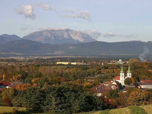
Pitten, a small town located in Lower Austria near the Vienna Woods, offers scenic hiking opportunities for outdoor enthusiasts. While it may not be as widely known as some larger hiking destinations, there are several trails in and around Pitten that cater to different skill levels and provide beautiful views of the surrounding landscape.
Hiking Trails in the Pitten Area:
-
Pitten Valley Trails: The valleys surrounding Pitten provide a variety of paths that can be explored on foot. Many of these trails are well-marked and suitable for both leisurely walks and more challenging hikes.
-
Vienna Woods (Wienerwald): Just a short distance from Pitten, the Vienna Woods is a vast area with numerous hiking trails. These trails offer diverse scenery, including forests, hills, and panoramic views of the surrounding region. The area is also home to various wildlife.
-
Local Nature Reserves: Explore nature reserves near Pitten, where you can find trails that allow for both hiking and birdwatching. The area's natural beauty and tranquility make it a perfect spot for nature lovers.
-
Historical Trails: Some hiking routes also feature historical elements, such as ancient ruins or traditional Austrian villages, giving hikers a chance to explore the cultural heritage of the region.
Tips for Hiking in Pitten:
- Check Trail Maps: Before heading out, it's a good idea to consult local maps or guides for trail conditions and difficulty levels.
- Weather Preparation: The weather in Austria can change quickly, so it's advisable to dress in layers and carry rain gear if needed.
- Stay Hydrated: Ensure you carry enough water, especially on warmer days, as some trails may have limited access to water sources.
- Respect Nature: As with any outdoor activity, be sure to follow Leave No Trace principles to preserve the beauty of the natural environment.
Getting There:
Pitten is accessible by car and public transportation from larger cities, such as Vienna. Depending on your starting point, plan your route accordingly to maximize your hiking experience.
Conclusion:
Hiking in and around Pitten offers a unique experience filled with natural beauty and tranquility. Whether you're looking for a short walk or an extended hike, there's something for everyone in this picturesque area of Austria. Always plan ahead and enjoy the breathtaking landscapes!
- Country:

- Local Dialing Code: 02627
- Licence Plate Code: NK
- Coordinates: 47° 42' 58" N, 16° 11' 11" E


- GPS tracks (wikiloc): [Link]
- AboveSeaLevel: 376 м m
- Area: 13.08 sq km
- Population: 2697
- Web site: http://www.pitten.at/
- Wikipedia en: wiki(en)
- Wikipedia: wiki(de)
- Wikidata storage: Wikidata: Q686394
- Wikipedia Commons Category: [Link]
- Freebase ID: [/m/02qzlmc]
- GeoNames ID: Alt: [2768746]
- VIAF ID: Alt: [168226145]
- archINFORM location ID: [10732]
- Library of Congress authority ID: Alt: [n98038647]
- WOEID: [543307]
- Austrian municipality key: [31823]
- Digital Atlas of the Roman Empire ID: [42809]
Shares border with regions:

Seebenstein
- municipality in Austria
Hiking in Seebenstein
Seebenstein, located in Lower Austria, is a charming destination for hiking enthusiasts. It offers beautiful landscapes, rich flora and fauna, and a variety of trails suitable for different skill levels. Here are some key points to consider when planning a hike in Seebenstein:...
- Country:
- Local Dialing Code: 02627
- Licence Plate Code: NK
- Coordinates: 47° 42' 7" N, 16° 8' 41" E
- GPS tracks (wikiloc): [Link]
- AboveSeaLevel: 348 м m
- Area: 9.09 sq km
- Population: 1401
- Web site: [Link]
Scheiblingkirchen-Thernberg
- municipality in Austria
Hiking in Scheiblingkirchen-Thernberg
Scheiblingkirchen-Thernberg, located in Lower Austria, offers a variety of hiking opportunities for outdoor enthusiasts. The region is characterized by its picturesque landscapes, rolling hills, and diverse natural environments. Here are some highlights for hiking in this area:...
- Country:
- Local Dialing Code: 02629
- Licence Plate Code: NK
- Coordinates: 47° 39' 0" N, 16° 8' 0" E
- GPS tracks (wikiloc): [Link]
- AboveSeaLevel: 373 м m
- Area: 37.83 sq km
- Population: 1864
- Web site: [Link]
Schwarzau am Steinfeld
- municipality in Austria
Hiking in Schwarzau am Steinfeld
Schwarzau am Steinfeld is a picturesque village located in the Lower Austria region of Austria, surrounded by stunning natural landscapes that are perfect for hiking enthusiasts. The area features a variety of trails that cater to different skill levels, making it suitable for both beginners and experienced hikers....
- Country:
- Local Dialing Code: 02627
- Licence Plate Code: NK
- Coordinates: 47° 43' 0" N, 16° 10' 0" E
- GPS tracks (wikiloc): [Link]
- AboveSeaLevel: 329 м m
- Area: 9.75 sq km
- Population: 1924
- Web site: [Link]

Bad Erlach
- municipality in Austria
Hiking in Bad Erlach
Bad Erlach, located in Austria, is an excellent destination for hiking enthusiasts, offering a variety of trails and beautiful landscapes. This charming town in Lower Austria is surrounded by the gentle hills of the Pitten Valley and the rolling countryside, making it ideal for both leisurely walks and more challenging hikes....
- Country:
- Local Dialing Code: 02627
- Licence Plate Code: WB
- Coordinates: 46° 59' 0" N, 15° 59' 0" E
- GPS tracks (wikiloc): [Link]
- AboveSeaLevel: 312 м m
- Area: 9.15 sq km
- Population: 3084
- Web site: [Link]