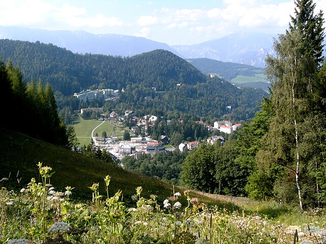
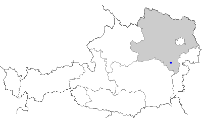
Neunkirchen District (Bezirk Neunkirchen)

- district in Austria
 Hiking in Neunkirchen District
Neunkirchen District, located in the state of Lower Austria, offers a variety of hiking opportunities amidst beautiful natural landscapes, charming villages, and historical sites. Here are some highlights to consider when hiking in the region:
Scenic Trails
-
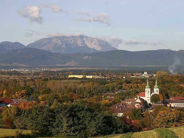
Raxalpe and Schneeberg: These two mountain ranges are nearby and offer numerous trails with varying difficulty levels. The views from the peaks are spectacular, particularly from Schneeberg, which is the highest mountain in Lower Austria.
-
Local Nature Trails: There are many well-marked hiking paths throughout Neunkirchen District. The trails vary from gentle walks suitable for families to more challenging hikes for seasoned adventurers.
-
Waterfall Trails: Look for trails that lead to beautiful waterfalls, particularly in the regional nature parks. These can provide a refreshing sight, especially during warmer months.
Natural Attractions
- Hohe Wand Nature Park: This park offers a range of trails and is famous for its dramatic cliffs and panoramic views. It's perfect for both hiking and rock climbing.
- Wildwoods and Rivers: Enjoy walking along river banks or through lush forests filled with wildlife. Areas around the rivers like the Sierning and the Piesting can be particularly serene.
Cultural Aspects
- Historical Sites: Combine hiking with cultural exploration by visiting historical sites and castles scattered throughout the district, such as those in the town of Neunkirchen itself.
- Local Cuisine: After a long hike, enjoy a meal at one of the local inns or restaurants that serve traditional Austrian dishes.
Practical Tips
- Weather Considerations: Always check the weather forecast before heading out as conditions can change rapidly, especially in mountainous areas.
- Gear and Preparation: Wear suitable hiking boots and bring adequate gear, including a water bottle, snacks, a map, and a first aid kit.
- Trail Etiquette: Respect nature and other hikers by following the "Leave No Trace" principles, staying on marked trails, and keeping noise levels down.
Accessibility
- The Neunkirchen District is well-connected by public transport, making it relatively easy to access various trailheads. Always verify local transport schedules.
Whether you are looking for a leisurely day hike or a more strenuous outdoor adventure, Neunkirchen District has something to offer for everyone who enjoys the beauty of nature. Remember to plan your hikes according to your skill level and always inform someone of your route before heading out. Happy hiking!
- Country:

- Licence Plate Code: NK
- Coordinates: 47° 43' 37" N, 16° 4' 54" E


- GPS tracks (wikiloc): [Link]
- AboveSeaLevel: 572 м m
- Area: 1146 sq km
- Web site: http://www.noel.gv.at/bezirke/BH-Neunkirchen.html
- Wikipedia en: wiki(en)
- Wikipedia: wiki(de)
- Wikidata storage: Wikidata: Q694386
- Wikipedia Commons Category: [Link]
- Freebase ID: [/m/0flb_x]
- GeoNames ID: Alt: [2770710]
- VIAF ID: Alt: [247854952]
- GND ID: Alt: [4802301-2]
- archINFORM location ID: [14637]
Includes regions:

Breitenstein
- municipality in Lower Austria
Hiking in Breitenstein
Breitenstein is a charming area in Lower Austria, known for its beautiful landscapes, hiking trails, and scenic views of the surrounding alpine terrain. Here's what you need to know about hiking in the region:...
- Country:
- Local Dialing Code: 02664
- Licence Plate Code: NK
- Coordinates: 47° 39' 41" N, 15° 49' 27" E
- GPS tracks (wikiloc): [Link]
- AboveSeaLevel: 779 м m
- Area: 20.29 sq km
- Population: 318
- Web site: [Link]
Breitenau, Lower Austria
- municipality in Austria
Hiking in Breitenau, Lower Austria
Breitenau, located in Lower Austria, offers picturesque hiking opportunities amidst stunning natural landscapes. The region is characterized by rolling hills, lush forests, and beautiful meadows. Here are some highlights of hiking in Breitenau:...
- Country:
- Postal Code: 2624
- Local Dialing Code: 02635
- Licence Plate Code: NK
- Coordinates: 47° 44' 0" N, 16° 9' 0" E
- GPS tracks (wikiloc): [Link]
- AboveSeaLevel: 343 м m
- Area: 9.63 sq km
- Population: 1576
- Web site: [Link]

Zöbern
- municipality in Austria
Hiking in Zöbern
Zöbern is a charming village located in the state of Lower Austria, surrounded by beautiful landscapes, rolling hills, and diverse natural habitats. Hiking in and around Zöbern offers a great opportunity to explore the scenic beauty and tranquility of the region....
- Country:
- Postal Code: 2851, 2852, 2870, 2871, 8244
- Local Dialing Code: 02642
- Licence Plate Code: NK
- Coordinates: 47° 30' 0" N, 16° 7' 0" E
- GPS tracks (wikiloc): [Link]
- AboveSeaLevel: 591 м m
- Area: 31.56 sq km
- Population: 1423
- Web site: [Link]

Neunkirchen
- town in Lower Austria
Hiking in Neunkirchen
Neunkirchen, a charming town nestled in Lower Austria, offers various hiking opportunities that cater to different skill levels and interests. Here are some key highlights you can expect when hiking in and around Neunkirchen:...
- Country:
- Postal Code: 2620
- Local Dialing Code: 02635
- Licence Plate Code: NK
- Coordinates: 47° 43' 37" N, 16° 4' 54" E
- GPS tracks (wikiloc): [Link]
- AboveSeaLevel: 371 м m
- Area: 20.28 sq km
- Population: 12879
- Web site: [Link]

Seebenstein
- municipality in Austria
Hiking in Seebenstein
Seebenstein, located in Lower Austria, is a charming destination for hiking enthusiasts. It offers beautiful landscapes, rich flora and fauna, and a variety of trails suitable for different skill levels. Here are some key points to consider when planning a hike in Seebenstein:...
- Country:
- Local Dialing Code: 02627
- Licence Plate Code: NK
- Coordinates: 47° 42' 7" N, 16° 8' 41" E
- GPS tracks (wikiloc): [Link]
- AboveSeaLevel: 348 м m
- Area: 9.09 sq km
- Population: 1401
- Web site: [Link]
Natschbach-Loipersbach
- municipality in Austria
Hiking in Natschbach-Loipersbach
Natschbach-Loipersbach, located in Lower Austria, offers a scenic environment for hiking enthusiasts. The region is characterized by its rolling hills, lush forests, and picturesque landscapes, making it an ideal location for both casual walkers and more experienced hikers....
- Country:
- Postal Code: 2620
- Local Dialing Code: 0 26 35
- Licence Plate Code: NK
- Coordinates: 47° 42' 0" N, 16° 6' 0" E
- GPS tracks (wikiloc): [Link]
- AboveSeaLevel: 366 м m
- Area: 10.62 sq km
- Population: 1702
- Web site: [Link]
Altendorf
- municipality in Austria
Hiking in Altendorf
Altendorf, Austria, is a charming village located in the picturesque region of the Austrian countryside, known for its stunning landscapes and a variety of hiking trails suitable for different skill levels. While it may not be as widely recognized as some of Austria's larger hiking destinations, it offers plenty of outdoor adventures....
- Country:
- Local Dialing Code: 02662
- Licence Plate Code: NK
- Coordinates: 47° 39' 0" N, 16° 1' 0" E
- GPS tracks (wikiloc): [Link]
- AboveSeaLevel: 680 м m
- Area: 7.2 sq km
- Population: 348
- Web site: [Link]
Scheiblingkirchen-Thernberg
- municipality in Austria
Hiking in Scheiblingkirchen-Thernberg
Scheiblingkirchen-Thernberg, located in Lower Austria, offers a variety of hiking opportunities for outdoor enthusiasts. The region is characterized by its picturesque landscapes, rolling hills, and diverse natural environments. Here are some highlights for hiking in this area:...
- Country:
- Local Dialing Code: 02629
- Licence Plate Code: NK
- Coordinates: 47° 39' 0" N, 16° 8' 0" E
- GPS tracks (wikiloc): [Link]
- AboveSeaLevel: 373 м m
- Area: 37.83 sq km
- Population: 1864
- Web site: [Link]

Willendorf
- municipality in Austria
Hiking in Willendorf
Willendorf, located in Austria, is known primarily for the famous Willendorf Venus figurine, an archaeological artifact, rather than for its hiking trails. However, the broader region of Lower Austria offers various opportunities for hiking enthusiasts. Here are some key points you might find helpful if you're interested in hiking around Willendorf and its surroundings:...
- Country:
- Local Dialing Code: 02620
- Licence Plate Code: NK
- Coordinates: 47° 47' 0" N, 16° 3' 0" E
- GPS tracks (wikiloc): [Link]
- AboveSeaLevel: 389 м m
- Area: 7.32 sq km
- Population: 971
- Web site: [Link]
Feistritz am Wechsel
- municipality in Austria
Hiking in Feistritz am Wechsel
Feistritz am Wechsel is a charming village located in the Lower Austria region of Austria, nestled in the scenic Wechsel Mountain range. This area offers a range of hiking opportunities for both novice and experienced hikers, featuring beautiful landscapes, lush forests, and stunning mountain views....
- Country:
- Postal Code: 2870, 2873, 2880
- Licence Plate Code: NK
- Coordinates: 47° 35' 58" N, 16° 3' 13" E
- GPS tracks (wikiloc): [Link]
- AboveSeaLevel: 487 м m
- Area: 23.78 sq km
- Population: 1038
- Web site: [Link]
Prigglitz
- municipality in Austria
Hiking in Prigglitz
Prigglitz is a scenic village located in Lower Austria, surrounded by the beautiful landscapes of the Wienerwald (Vienna Woods). The region offers a variety of hiking opportunities, ranging from leisurely walks to more challenging hikes, making it suitable for all levels of hikers....
- Country:
- Postal Code: 2630, 2640
- Local Dialing Code: 02662
- Licence Plate Code: NK
- Coordinates: 47° 42' 9" N, 15° 55' 41" E
- GPS tracks (wikiloc): [Link]
- AboveSeaLevel: 635 м m
- Area: 17.97 sq km
- Population: 434
- Web site: [Link]
Wimpassing im Schwarzatale
- municipality in Austria
Hiking in Wimpassing im Schwarzatale
Wimpassing im Schwarzatale is a charming village located in Austria, surrounded by beautiful landscapes perfect for hiking enthusiasts. The area is characterized by rolling hills, lush forests, and picturesque mountain views, making it an excellent destination for nature lovers....
- Country:
- Postal Code: 2632
- Local Dialing Code: 02630
- Licence Plate Code: NK
- Coordinates: 47° 42' 0" N, 16° 1' 0" E
- GPS tracks (wikiloc): [Link]
- AboveSeaLevel: 396 м m
- Area: 2.07 sq km
- Population: 1616
- Web site: [Link]
Semmering
- town in Lower Austria, Austria
Hiking in Semmering
Semmering, Austria, is a popular hiking destination known for its stunning landscapes, diverse trails, and rich cultural history. Nestled in the Eastern Alps, it offers a mix of challenging hikes and family-friendly options, making it suitable for hikers of all levels....
- Country:
- Postal Code: 2680
- Local Dialing Code: 02664
- Licence Plate Code: NK
- Coordinates: 47° 37' 0" N, 15° 49' 0" E
- GPS tracks (wikiloc): [Link]
- AboveSeaLevel: 985 м m
- Area: 8.66 sq km
- Population: 577
- Web site: [Link]

Ternitz
- municipality in Austria
Hiking in Ternitz
Ternitz, located in Lower Austria, offers a variety of hiking opportunities that cater to different skill levels. The region is characterized by its beautiful landscapes, rolling hills, and lush forests, providing a scenic backdrop for outdoor enthusiasts....
- Country:
- Postal Code: 2620, 2630, 2631, 2632, 2732, 2733, 2734
- Local Dialing Code: 02630
- Licence Plate Code: NK
- Coordinates: 47° 43' 0" N, 16° 2' 0" E
- GPS tracks (wikiloc): [Link]
- AboveSeaLevel: 393 м m
- Area: 65.35 sq km
- Population: 14632
- Web site: [Link]

Reichenau an der Rax
- municipality in Austria
Hiking in Reichenau an der Rax
Reichenau an der Rax, located in Austria, is a stunning destination for hiking enthusiasts, offering a variety of trails that cater to different skill levels and preferences. Nestled in the Rax-Schneeberg region, Reichenau provides breathtaking views of the surrounding mountains and valleys, making it a popular spot for both casual walkers and seasoned hikers....
- Country:
- Postal Code: 2651, 2654
- Local Dialing Code: 02666
- Licence Plate Code: NK
- Coordinates: 47° 42' 0" N, 15° 50' 0" E
- GPS tracks (wikiloc): [Link]
- AboveSeaLevel: 484 м m
- Area: 89.5 sq km
- Population: 2601
- Web site: [Link]

Schottwien
- municipality in Austria
Hiking in Schottwien
Schottwien is a charming village located in the Lower Austria region of Austria, surrounded by beautiful natural landscapes that offer numerous hiking opportunities. Here are some highlights and tips for hiking in and around Schottwien:...
- Country:
- Postal Code: 2641, 2642
- Local Dialing Code: 02663
- Licence Plate Code: NK
- Coordinates: 47° 38' 0" N, 15° 52' 0" E
- GPS tracks (wikiloc): [Link]
- AboveSeaLevel: 569 м m
- Area: 12.52 sq km
- Population: 660
- Web site: [Link]
Schwarzau am Steinfeld
- municipality in Austria
Hiking in Schwarzau am Steinfeld
Schwarzau am Steinfeld is a picturesque village located in the Lower Austria region of Austria, surrounded by stunning natural landscapes that are perfect for hiking enthusiasts. The area features a variety of trails that cater to different skill levels, making it suitable for both beginners and experienced hikers....
- Country:
- Local Dialing Code: 02627
- Licence Plate Code: NK
- Coordinates: 47° 43' 0" N, 16° 10' 0" E
- GPS tracks (wikiloc): [Link]
- AboveSeaLevel: 329 м m
- Area: 9.75 sq km
- Population: 1924
- Web site: [Link]
Trattenbach
- municipality in Austria
Hiking in Trattenbach
Trattenbach, located in Austria, is surrounded by beautiful natural landscapes, making it a great destination for hiking enthusiasts. The region is characterized by lush forests, rolling hills, and clear streams, providing a variety of trails suitable for different skill levels....
- Country:
- Postal Code: 2881
- Local Dialing Code: 02641
- Licence Plate Code: NK
- Coordinates: 47° 35' 43" N, 15° 53' 13" E
- GPS tracks (wikiloc): [Link]
- AboveSeaLevel: 777 м m
- Area: 30.91 sq km
- Population: 545
- Web site: [Link]
Otterthal
- municipality in Austria
Hiking in Otterthal
Otterthal, nestled in the scenic landscapes of Austria, offers a range of beautiful hiking opportunities for outdoor enthusiasts. Here’s what you can look forward to when hiking in this area:...
- Country:
- Postal Code: 2880
- Local Dialing Code: 02641
- Licence Plate Code: NK
- Coordinates: 47° 37' 0" N, 15° 55' 0" E
- GPS tracks (wikiloc): [Link]
- AboveSeaLevel: 632 м m
- Area: 6.17 sq km
- Population: 592
- Web site: [Link]

Kirchberg am Wechsel
- municipality in Austria
Hiking in Kirchberg am Wechsel
Kirchberg am Wechsel is a charming town in Austria, located in the eastern part of the country within the Wienerwald (Vienna Woods) region. It’s a fantastic destination for hiking enthusiasts, offering a variety of trails that cater to all levels of experience....
- Country:
- Local Dialing Code: 02641
- Licence Plate Code: NK
- Coordinates: 47° 36' 31" N, 15° 59' 33" E
- GPS tracks (wikiloc): [Link]
- AboveSeaLevel: 581 м m
- Area: 51.17 sq km
- Population: 2505
- Web site: [Link]

Puchberg am Schneeberg
- municipality in Austria
Hiking in Puchberg am Schneeberg
Puchberg am Schneeberg is a charming village located in Lower Austria, surrounded by the scenic Beauty of the Schneeberg massif, which is the highest mountain in the Eastern Alps. Hiking in this area offers a range of experiences, from gentle walks to challenging climbs, making it suitable for hikers of all abilities....
- Country:
- Local Dialing Code: 02636
- Licence Plate Code: NK
- Coordinates: 47° 47' 0" N, 15° 54' 0" E
- GPS tracks (wikiloc): [Link]
- AboveSeaLevel: 585 м m
- Area: 83.17 sq km
- Population: 2683
- Web site: [Link]

Höflein an der Hohen Wand
- town in the district of Neunkirchen in the Austrian state of Lower Austria
Hiking in Höflein an der Hohen Wand
Höflein an der Hohen Wand is a charming village located in Austria, nestled at the foothills of the Hohe Wand mountain range, which offers a variety of hiking opportunities for outdoor enthusiasts. The area is known for its stunning landscapes, with panoramic views, rocky cliffs, and diverse flora and fauna....
- Country:
- Local Dialing Code: 02620
- Licence Plate Code: NK
- Coordinates: 47° 47' 47" N, 16° 1' 42" E
- GPS tracks (wikiloc): [Link]
- AboveSeaLevel: 490 м m
- Area: 8.94 sq km
- Population: 895
- Web site: [Link]

Schwarzau im Gebirge
- municipality in Austria
Hiking in Schwarzau im Gebirge
Schwarzau im Gebirge is a charming village located in Austria, nestled within the picturesque landscape of the Semmering region. It's a fantastic destination for hiking enthusiasts, offering a variety of trails suitable for different skill levels....
- Country:
- Postal Code: 2661, 2662
- Local Dialing Code: 02667
- Licence Plate Code: NK
- Coordinates: 47° 48' 0" N, 15° 42' 0" E
- GPS tracks (wikiloc): [Link]
- AboveSeaLevel: 618 м m
- Area: 190.44 sq km
- Population: 644
- Web site: [Link]
Würflach
- town in the district of Neunkirchen in the Austrian state of Lower Austria
Hiking in Würflach
Würflach is a picturesque village located in Lower Austria, surrounded by beautiful landscapes that are perfect for hiking enthusiasts. The region boasts a variety of trails that cater to different skill levels, making it a great destination for both beginners and experienced hikers....
- Country:
- Postal Code: 2732
- Local Dialing Code: 0 26 20
- Licence Plate Code: NK
- Coordinates: 47° 46' 26" N, 16° 3' 17" E
- GPS tracks (wikiloc): [Link]
- AboveSeaLevel: 430 м m
- Area: 12.33 sq km
- Population: 1592
- Web site: [Link]
Thomasberg
- municipality in Austria
Hiking in Thomasberg
Thomasberg is a beautiful area for hiking, particularly known for its scenic views, diverse terrain, and the opportunity to connect with nature. Here are some key highlights and tips for hiking in this region:...
- Country:
- Local Dialing Code: 02644
- Licence Plate Code: NK
- Coordinates: 47° 34' 0" N, 16° 8' 0" E
- GPS tracks (wikiloc): [Link]
- AboveSeaLevel: 541 м m
- Area: 28.99 sq km
- Population: 1284
- Web site: [Link]
Bürg-Vöstenhof
- municipality in Austria
Hiking in Bürg-Vöstenhof
Bürg-Vöstenhof is a charming area located in Germany, well-known for its picturesque landscapes and outdoor recreation opportunities, including hiking. The region typically features a variety of marked trails that cater to different skill levels, making it accessible for both novice hikers and seasoned trekkers....
- Country:
- Postal Code: 2630
- Local Dialing Code: 02630
- Licence Plate Code: NK
- Coordinates: 47° 43' 0" N, 15° 58' 0" E
- GPS tracks (wikiloc): [Link]
- AboveSeaLevel: 570 м m
- Area: 25.12 sq km
- Population: 179
- Web site: [Link]


Sankt Corona am Wechsel
- municipality in Austria
Hiking in Sankt Corona am Wechsel
Sankt Corona am Wechsel is a scenic destination located in the Austrian Alps, known for its accessible and diverse hiking trails. Here are some key highlights and tips for hiking in this beautiful area:...
- Country:
- Postal Code: 2641
- Local Dialing Code: 02641
- Licence Plate Code: NK
- Coordinates: 47° 35' 0" N, 16° 0' 0" E
- GPS tracks (wikiloc): [Link]
- AboveSeaLevel: 844 м m
- Area: 8.7 sq km
- Population: 390
- Web site: [Link]
Schrattenbach
- municipality in Austria
Hiking in Schrattenbach
Schrattenbach is a picturesque area located in Austria, known for its stunning landscapes and hiking opportunities. It’s often appreciated for its natural beauty, featuring a mix of forested areas, open meadows, and rocky terrain....
- Country:
- Postal Code: 2733
- Local Dialing Code: 02637
- Licence Plate Code: NK
- Coordinates: 47° 47' 0" N, 16° 0' 0" E
- GPS tracks (wikiloc): [Link]
- AboveSeaLevel: 517 м m
- Area: 10.82 sq km
- Population: 363
- Web site: [Link]

Raach am Hochgebirge
- municipality in Austria
Hiking in Raach am Hochgebirge
Raach am Hochgebirge is a picturesque village located in the eastern part of Austria, nestled within the stunning landscapes of the Alps. It's an excellent destination for hiking enthusiasts, offering a variety of trails that cater to different skill levels and preferences....
- Country:
- Postal Code: 2640
- Local Dialing Code: 02662
- Licence Plate Code: NK
- Coordinates: 47° 38' 36" N, 15° 55' 49" E
- GPS tracks (wikiloc): [Link]
- AboveSeaLevel: 813 м m
- Area: 13.25 sq km
- Population: 281
- Web site: [Link]
Aspangberg-St. Peter
- municipality in Austria
Hiking in Aspangberg-St. Peter
Aspangberg-Sankt Peter, located in the Lower Austria region of Austria, is a fantastic destination for hiking enthusiasts. It offers a mix of stunning natural landscapes, picturesque villages, and a variety of trails suitable for different skill levels. Here are some highlights and tips for hiking in this area:...
- Country:
- Local Dialing Code: 02642
- Licence Plate Code: NK
- Coordinates: 47° 33' 2" N, 16° 1' 9" E
- GPS tracks (wikiloc): [Link]
- AboveSeaLevel: 490 м m
- Area: 81.49 sq km
- Population: 1888
- Web site: [Link]


Grimmenstein
- municipality in Austria
Hiking in Grimmenstein
Grimmenstein is a beautiful area located in Austria, known for its picturesque landscapes and outdoor recreational opportunities. The region is characterized by rolling hills, forested areas, and stunning views of the surrounding countryside, making it a fantastic destination for hikers of all levels. Here are some key points to consider when hiking in Grimmenstein:...
- Country:
- Local Dialing Code: 02644
- Licence Plate Code: NK
- Coordinates: 47° 36' 55" N, 16° 7' 36" E
- GPS tracks (wikiloc): [Link]
- AboveSeaLevel: 405 м m
- Area: 14.78 sq km
- Population: 1356
- Web site: [Link]


Payerbach
- municipality in Austria
Hiking in Payerbach
Payerbach is a picturesque village located in the Lower Austria region, nestled at the foot of the Rax mountains. It serves as a great starting point for various hiking trails that cater to different levels of experience and fitness. Here are some key highlights of hiking in and around Payerbach:...
- Country:
- Local Dialing Code: 02666
- Licence Plate Code: NK
- Coordinates: 47° 40' 0" N, 15° 50' 0" E
- GPS tracks (wikiloc): [Link]
- AboveSeaLevel: 483 м m
- Area: 17.66 sq km
- Population: 2076
- Web site: [Link]
Mönichkirchen
- municipality in Austria
Hiking in Mönichkirchen
Mönichkirchen is a charming village located in the Styrian region of Austria, known for its picturesque landscapes and accessible hiking trails. Nestled in the foothills of the Eastern Alps, Mönichkirchen offers a variety of hiking opportunities suitable for all levels of hikers....
- Country:
- Postal Code: 2872, 7421
- Local Dialing Code: 02649
- Licence Plate Code: NK
- Coordinates: 47° 30' 0" N, 16° 2' 0" E
- GPS tracks (wikiloc): [Link]
- AboveSeaLevel: 967 м m
- Area: 16.31 sq km
- Population: 606
- Web site: [Link]

Gloggnitz
- municipality in Austria
Hiking in Gloggnitz
Gloggnitz is a charming town located in Austria's Lower Austria region, surrounded by picturesque landscapes and a variety of hiking opportunities. Here are some key points to consider if you're planning a hiking trip to Gloggnitz:...
- Country:
- Local Dialing Code: 02662
- Licence Plate Code: NK
- Coordinates: 47° 40' 33" N, 15° 56' 18" E
- GPS tracks (wikiloc): [Link]
- AboveSeaLevel: 442 м m
- Area: 19.55 sq km
- Population: 5916
- Web site: [Link]

Aspang-Markt
- municipality in Austria
Hiking in Aspang-Markt
Hiking in Aspang-Markt, located in the Lower Austria region of Austria, offers a delightful experience for nature lovers and outdoor enthusiasts. This quaint town is situated in the foothills of the Alps, providing scenic views and a variety of trails suitable for different skill levels....
- Country:
- Postal Code: 2870
- Local Dialing Code: 02642
- Licence Plate Code: NK
- Coordinates: 47° 33' 21" N, 16° 5' 29" E
- GPS tracks (wikiloc): [Link]
- AboveSeaLevel: 498 м m
- Area: 5.2 sq km
- Population: 1816
- Web site: [Link]
Warth
- municipality in Lower Austria, Austria
Hiking in Warth
Warth, located in Lower Austria, is a charming destination for hiking enthusiasts. This picturesque village is situated in proximity to the scenic landscapes of the Vienna Woods and the foothills of the Alps, offering varied trails that suit different skill levels....
- Country:
- Local Dialing Code: 02629
- Licence Plate Code: NK
- Coordinates: 47° 39' 12" N, 16° 7' 39" E
- GPS tracks (wikiloc): [Link]
- AboveSeaLevel: 385 м m
- Area: 29.97 sq km
- Population: 1512
- Web site: [Link]
Buchbach
- municipality in Austria
Hiking in Buchbach
Buchbach, located in Austria, is an excellent destination for hiking enthusiasts, offering a variety of trails that cater to different skill levels. Nestled in a picturesque landscape of rolling hills, lush forests, and scenic mountain views, it provides both beginners and experienced hikers with ample opportunities to explore the natural beauty of the region....
- Country:
- Local Dialing Code: 02630
- Licence Plate Code: NK
- Coordinates: 47° 41' 48" N, 15° 59' 3" E
- GPS tracks (wikiloc): [Link]
- AboveSeaLevel: 485 м m
- Area: 2.99 sq km
- Population: 330
- Web site: [Link]

Pitten
- municipality in Austria
Hiking in Pitten
Pitten, a small town located in Lower Austria near the Vienna Woods, offers scenic hiking opportunities for outdoor enthusiasts. While it may not be as widely known as some larger hiking destinations, there are several trails in and around Pitten that cater to different skill levels and provide beautiful views of the surrounding landscape....
- Country:
- Local Dialing Code: 02627
- Licence Plate Code: NK
- Coordinates: 47° 42' 58" N, 16° 11' 11" E
- GPS tracks (wikiloc): [Link]
- AboveSeaLevel: 376 м m
- Area: 13.08 sq km
- Population: 2697
- Web site: [Link]
Enzenreith
- municipality in Austria
Hiking in Enzenreith
Enzenreith, located in Austria, is a picturesque area that offers a variety of hiking opportunities, especially if you enjoy nature-filled landscapes and mountainous terrain. Here are some insights for hiking in and around Enzenreith:...
- Country:
- Postal Code: 2632, 2640
- Local Dialing Code: 02662
- Licence Plate Code: NK
- Coordinates: 47° 40' 0" N, 15° 57' 0" E
- GPS tracks (wikiloc): [Link]
- AboveSeaLevel: 450 м m
- Area: 9.21 sq km
- Population: 1946
- Web site: [Link]
Edlitz
- municipality in Austria
Hiking in Edlitz
Edlitz is a charming village located in Austria, surrounded by beautiful landscapes ideal for hiking enthusiasts. Nestled in the foothills of the Alps, the region offers a variety of trails that cater to all skill levels. Here are some highlights and tips for hiking in Edlitz:...
- Country:
- Local Dialing Code: 02644
- Licence Plate Code: NK
- Coordinates: 47° 35' 0" N, 16° 8' 0" E
- GPS tracks (wikiloc): [Link]
- AboveSeaLevel: 454 м m
- Area: 14.23 sq km
- Population: 934
- Web site: [Link]
Grafenbach-Sankt Valentin
- municipality in Austria
Hiking in Grafenbach-Sankt Valentin
Grafenbach-Sankt Valentin, located in Austria, offers a beautiful backdrop for hiking enthusiasts. This region is characterized by picturesque landscapes, lush forests, and rolling hills, making it ideal for a variety of outdoor activities....
- Country:
- Postal Code: 2632
- Local Dialing Code: 02630
- Licence Plate Code: NK
- Coordinates: 47° 41' 0" N, 16° 0' 0" E
- GPS tracks (wikiloc): [Link]
- AboveSeaLevel: 430 м m
- Area: 13.9 sq km
- Population: 2264
- Web site: [Link]

Grünbach am Schneeberg
- town in the Neunkirchen district in Lower Austria.
Hiking in Grünbach am Schneeberg
Grünbach am Schneeberg is a picturesque village located in the Lower Austrian region, nestled near the Schneeberg mountain, which is one of the most sought-after hiking destinations in the area. Here’s what you can expect when hiking around Grünbach am Schneeberg:...
- Country:
- Postal Code: 2733
- Local Dialing Code: 02637
- Licence Plate Code: NK
- Coordinates: 47° 47' 53" N, 15° 59' 13" E
- GPS tracks (wikiloc): [Link]
- AboveSeaLevel: 557 м m
- Area: 7.37 sq km
- Population: 1647
- Web site: [Link]
Wartmannstetten
- municipality in Austria
Hiking in Wartmannstetten
Wartmannstetten is a small, picturesque village in Austria, located in the region of Lower Austria. It is surrounded by beautiful natural landscapes, making it a great destination for hiking enthusiasts. Here are some aspects to consider when hiking in Wartmannstetten:...
- Country:
- Postal Code: 2620
- Local Dialing Code: 02635
- Licence Plate Code: NK
- Coordinates: 47° 41' 0" N, 16° 4' 0" E
- GPS tracks (wikiloc): [Link]
- AboveSeaLevel: 419 м m
- Area: 21.41 sq km
- Population: 1605
- Web site: [Link]

Sankt Egyden am Steinfeld
- municipality in Austria
Hiking in Sankt Egyden am Steinfeld
Sankt Egyden am Steinfeld is a charming village located in Austria, surrounded by beautiful landscapes that are ideal for hiking enthusiasts. The area offers a mix of gentle rolling hills, forested paths, and scenic views, making it a great spot for both casual walkers and more experienced hikers....
- Country:
- Postal Code: 2731
- Local Dialing Code: 02638
- Licence Plate Code: NK
- Coordinates: 47° 46' 54" N, 16° 6' 12" E
- GPS tracks (wikiloc): [Link]
- AboveSeaLevel: 350 м m
- Area: 26.17 sq km
- Population: 1924
- Web site: [Link]