Piverone (Piverone)

- Italian comune
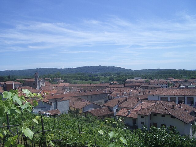
 Hiking in Piverone
Piverone, located in the Piedmont region of Italy, offers a variety of hiking opportunities amidst beautiful landscapes. The area is characterized by rolling hills, vineyards, and a rich combination of natural and cultural attractions.
Hiking Trails:
-
Sentiero del Bosco - This woodsy trail winds through forests and offers a chance to see local flora and fauna. It’s a moderate hike suitable for families and casual hikers.
-
Vineyard Paths - Several paths wind through the vineyards surrounding Piverone. These trails provide picturesque views and the chance to learn about local viticulture.
-
Historical Routes - Some trails connect historical sites, such as ancient churches or ruins, offering a blend of cultural exploration and outdoor activity.
Trail Conditions and Recommendations:
- Trail Markings: Many trails are well-marked, but it’s always advisable to carry a local hiking map or use a GPS navigation app.
- Seasonal Considerations: Spring and fall are ideal times to hike in the area due to mild weather. Summer can be hot, so early morning hikes are recommended.
- Gear: Sturdy hiking shoes are important due to varied terrain, and don’t forget to bring plenty of water and snacks.
Local Attractions:
- Castello di Masino: A nearby historical site that can be integrated into a hiking itinerary.
- Cultural Experiences: Look for local festivals or events, especially those related to wine, which can enhance your hiking experience.
Safety Tips:
- Always inform someone of your hiking plans.
- Check the weather forecast before heading out.
- Be mindful of wildlife and stick to marked paths.
Enjoy exploring the beautiful landscapes and cultural heritage of Piverone while hiking!
- Country:

- Postal Code: 10010
- Local Dialing Code: 0125
- Licence Plate Code: TO
- Coordinates: 45° 27' 0" N, 8° 0' 0" E


- GPS tracks (wikiloc): [Link]
- AboveSeaLevel: 295 м m
- Area: 11.03 sq km
- Population: 1349
- Web site: http://www.comune.piverone.to.it
- Wikipedia en: wiki(en)
- Wikipedia: wiki(it)
- Wikidata storage: Wikidata: Q10193
- Wikipedia Commons Category: [Link]
- Freebase ID: [/m/0g8kh0]
- GeoNames ID: Alt: [6543397]
- VIAF ID: Alt: [244778861]
- OSM relation ID: [45024]
- TGN ID: [1046033]
- UN/LOCODE: [ITPVY]
- ISTAT ID: 001196
- Italian cadastre code: G719
Shares border with regions:

Magnano
- Italian comune
Hiking in Magnano
Magnano, located in the province of Biella in northern Italy, offers a beautiful setting for hiking enthusiasts. This area is known for its stunning landscapes, rolling hills, and rich natural biodiversity, making it an excellent destination for outdoor activities....
- Country:
- Postal Code: 13887
- Local Dialing Code: 015
- Licence Plate Code: BI
- Coordinates: 45° 27' 48" N, 8° 0' 11" E
- GPS tracks (wikiloc): [Link]
- AboveSeaLevel: 543 м m
- Area: 10.56 sq km
- Population: 398
- Web site: [Link]

Viverone
- Italian comune
Hiking in Viverone
Viverone, located in the Piedmont region of northern Italy, is a beautiful area known for its picturesque landscape, particularly around Lake Viverone. The region offers a variety of hiking opportunities, suitable for different skill levels, making it a great destination for outdoor enthusiasts....
- Country:
- Postal Code: 13886
- Local Dialing Code: 0161
- Licence Plate Code: BI
- Coordinates: 45° 25' 29" N, 8° 3' 16" E
- GPS tracks (wikiloc): [Link]
- AboveSeaLevel: 287 м m
- Area: 12.26 sq km
- Population: 1406
- Web site: [Link]
Zimone
- Italian comune
Hiking in Zimone
Zimone is a charming municipality located in the Piedmont region of Italy, nestled in the foothills of the Alps. While it may not be as widely recognized as some other hiking destinations, Zimone offers a variety of trails that are perfect for nature enthusiasts and hikers of all skill levels. Here are some key aspects to consider when hiking in Zimone:...
- Country:
- Postal Code: 13887
- Local Dialing Code: 015
- Licence Plate Code: BI
- Coordinates: 45° 27' 0" N, 8° 0' 0" E
- GPS tracks (wikiloc): [Link]
- AboveSeaLevel: 465 м m
- Area: 2.95 sq km
- Population: 410
- Web site: [Link]

Albiano d'Ivrea
- Italian comune
Hiking in Albiano d'Ivrea
Albiano d'Ivrea is a charming municipality located in the Piedmont region of Italy, surrounded by picturesque natural landscapes, making it an excellent spot for hiking enthusiasts. Here are some highlights and tips for hiking in the area:...
- Country:
- Postal Code: 10010
- Local Dialing Code: 0125
- Licence Plate Code: TO
- Coordinates: 45° 26' 0" N, 7° 57' 0" E
- GPS tracks (wikiloc): [Link]
- AboveSeaLevel: 230 м m
- Area: 11.73 sq km
- Population: 1677
- Web site: [Link]


Azeglio
- Italian comune
Hiking in Azeglio
Azeglio is a charming location situated in the Piedmont region of Italy, known for its beautiful landscapes and hiking opportunities. The area is characterized by rolling hills, picturesque vineyards, and a rich culture. Here are some key points you might find interesting about hiking in and around Azeglio:...
- Country:
- Postal Code: 10010
- Local Dialing Code: 0125
- Licence Plate Code: TO
- Coordinates: 45° 25' 0" N, 8° 0' 0" E
- GPS tracks (wikiloc): [Link]
- AboveSeaLevel: 260 м m
- Area: 9.96 sq km
- Population: 1267
- Web site: [Link]


Bollengo
- Italian comune
Hiking in Bollengo
Bollengo is a small town located in the Piedmont region of Italy, surrounded by beautiful landscapes that are perfect for hiking enthusiasts. The area offers a variety of trails suited for different experience levels, from gentle walks to more challenging hikes....
- Country:
- Postal Code: 10012
- Local Dialing Code: 0125
- Licence Plate Code: TO
- Coordinates: 45° 28' 0" N, 7° 57' 0" E
- GPS tracks (wikiloc): [Link]
- AboveSeaLevel: 234 м m
- Area: 14.22 sq km
- Population: 2144
- Web site: [Link]


Palazzo Canavese
- Italian comune
Hiking in Palazzo Canavese
Palazzo Canavese, located in the province of Turin in the Piedmont region of Italy, offers a charming setting for outdoor activities, including hiking. The area is characterized by its picturesque landscapes, rolling hills, and scenic views of the surrounding countryside, making it a fantastic destination for hiking enthusiasts....
- Country:
- Postal Code: 10010
- Local Dialing Code: 0125
- Licence Plate Code: TO
- Coordinates: 45° 27' 0" N, 7° 59' 0" E
- GPS tracks (wikiloc): [Link]
- AboveSeaLevel: 248 м m
- Area: 5.08 sq km
- Population: 842
- Web site: [Link]