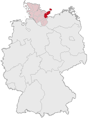
Plön District (Kreis Plön)

- German district
 Hiking in Plön District
Plön, located in Schleswig-Holstein, Germany, is known for its beautiful landscapes, scenic lakes, and rich history, making it a great destination for hiking enthusiasts. Here are some key highlights about hiking in the Plön district:
Scenic Trails
- Plöner See: One of the largest lakes in Schleswig-Holstein, surrounded by picturesque landscapes. Trails around the lake offer stunning views and opportunities for wildlife spotting.
- Nature Park Holstein Switzerland: This area features rolling hills, forests, and lakes. Numerous hiking trails connect charming villages and offer a mix of easy and moderate routes.
- The E1 European Long Distance Path: A part of this extensive trail runs through the Plön district, allowing hikers to experience both regional landscapes and broader European connections.
Popular Hikes
- Around Plöner Lake: This is a relatively easy loop that offers lovely views of the water. It’s suitable for families and less experienced hikers.
- The Bungsberg: This is the highest elevation in Schleswig-Holstein and offers more challenging terrain. The summit provides panoramic views of the surrounding countryside and is a rewarding destination for adventurous hikers.
- Nature trails in the surrounding forests: Various forest paths are available, offering a tranquil hiking experience surrounded by greenery.
Tips for Hiking in Plön
- Weather Preparation: Check the local weather forecast and dress appropriately, as conditions can change quickly.
- Footwear: Sturdy hiking boots are recommended, especially for trails that may be uneven or have roots and rocks.
- Wildlife: Be respectful of nature and wildlife. It's common to encounter various birds and, occasionally, deer.
- Maps and Local Guides: Consider using local maps or guides to enhance your hiking experience. They can provide insights into the flora, fauna, and cultural landmarks along the trails.
Accessibility
Most trails in the Plön district are accessible, with clear signage. Some might be more suitable for experienced hikers, so it's always a good idea to assess your fitness level before embarking on longer or more stimulating trails.
Potentials for Relaxation
After hiking, you can relax in one of the many charming villages or towns in the area, enjoy local cuisine, or take a swim in the lake during warmer months.
In summary, Plön offers a wonderful hiking experience amid beautiful natural surroundings, with a variety of trails suitable for all skill levels. Whether you're looking for a casual day hike or a more challenging adventure, you'll find plenty of options in this picturesque district.
- Country:

- Coordinates: 54° 15' 0" N, 10° 25' 12" E


- GPS tracks (wikiloc): [Link]
- AboveSeaLevel: 28 м m
- Area: 1082.7 sq km
- Web site: http://www.kreis-ploen.de/
- Wikipedia en: wiki(en)
- Wikipedia: wiki(de)
- Wikidata storage: Wikidata: Q2970
- Wikipedia Commons Category: [Link]
- Freebase ID: [/m/0n28m]
- GeoNames ID: Alt: [2853161]
- VIAF ID: Alt: [143098212]
- OSM relation ID: [62545]
- GND ID: Alt: [4046386-2]
- archINFORM location ID: [7976]
- Library of Congress authority ID: Alt: [n82230637]
- TGN ID: [7119974]
- National Library of Israel ID: [000996913]
- NUTS code: [DEF0A]
- BabelNet ID: [03825293n]
- German district key: 01057
Shares border with regions:


Kiel
- city in Schleswig-Holstein, Germany
Hiking in Kiel
Kiel, located in northern Germany, is known more for its maritime culture and proximity to the Baltic Sea than for traditional hiking trails. However, it offers a variety of outdoor activities, including scenic walks and easy hiking options. Here are some points to consider for hiking in and around Kiel:...
- Country:
- Postal Code: 24159; 24103–24159
- Local Dialing Code: 0431
- Licence Plate Code: KI
- Coordinates: 54° 19' 24" N, 10° 8' 22" E
- GPS tracks (wikiloc): [Link]
- AboveSeaLevel: 5 м m
- Area: 118.65 sq km
- Population: 247236
- Web site: [Link]
Rendsburg-Eckernförde
- German district
Hiking in Rendsburg-Eckernförde
Rendsburg-Eckernförde is a beautiful district located in Schleswig-Holstein, Germany. It offers a diverse range of hiking opportunities, ideal for both novice and experienced hikers. Here are some highlights and tips for hiking in this region:...
- Country:
- Licence Plate Code: RD
- Coordinates: 54° 15' 0" N, 9° 45' 0" E
- GPS tracks (wikiloc): [Link]
- AboveSeaLevel: 9 м m
- Web site: [Link]

Ostholstein
- German district
Hiking in Ostholstein
Ostholstein, located in the northern part of Germany in Schleswig-Holstein, is a beautiful area known for its diverse landscapes, coastal scenery, and rich cultural history. Here are some highlights and tips for hiking in Ostholstein:...
- Country:
- Licence Plate Code: OH
- Coordinates: 54° 10' 12" N, 10° 49' 48" E
- GPS tracks (wikiloc): [Link]
- AboveSeaLevel: 46 м m
- Web site: [Link]
Segeberg
- district in Germany
Hiking in Segeberg
Segeberg, located in Schleswig-Holstein, Germany, offers a variety of hiking opportunities amidst its beautiful natural landscapes. The area is renowned for its rolling hills, dense forests, and picturesque lakes, making it a great destination for outdoor enthusiasts....
- Country:
- Licence Plate Code: SE
- Coordinates: 53° 55' 12" N, 10° 10' 12" E
- GPS tracks (wikiloc): [Link]
- AboveSeaLevel: 37 м m
- Area: 1344.39 sq km
- Population: 272235
- Web site: [Link]


Neumünster
- city in Schleswig-Holstein, Germany
Hiking in Neumünster
Neumünster, located in Schleswig-Holstein, Germany, may not be a well-known hiking destination, but it offers some pleasant walking and hiking options in the surrounding areas. Here are some aspects to consider for hiking in and around Neumünster:...
- Country:
- Postal Code: 24534–24539
- Local Dialing Code: 04321
- Licence Plate Code: NMS
- Coordinates: 54° 4' 17" N, 9° 59' 24" E
- GPS tracks (wikiloc): [Link]
- AboveSeaLevel: 22 м m
- Area: 71.63 sq km
- Population: 79680
- Web site: [Link]