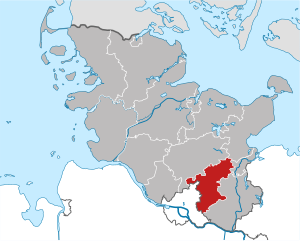
Ostholstein (Kreis Ostholstein)

- German district
 Hiking in Ostholstein
Ostholstein, located in the northern part of Germany in Schleswig-Holstein, is a beautiful area known for its diverse landscapes, coastal scenery, and rich cultural history. Here are some highlights and tips for hiking in Ostholstein:
Trails and Routes
-
Eutin to Malente: This is a popular hike that connects the town of Eutin with Malente, passing through picturesque forests and alongside lakes. The scenery is particularly beautiful in spring and autumn.
-
Holstein Switzerland: The region features numerous trails that meander through rolling hills, dense forests, and around lakes like the Dieksee and Kellersee. The Holstein Switzerland Nature Park offers various marked trails suitable for all levels.
-
Timmendorfer Strand to Niendorf: This coastal path takes you along the Baltic Sea, providing stunning views of the water and opportunities to enjoy the beach and surrounding dunes.
-
Fehmarn Island: Although technically a bit outside Ostholstein, the nearby Fehmarn Island offers lovely coastal paths, combining beach hiking with the charm of small fishing villages.
Highlights
-
Nature Reserves: Many parts of Ostholstein are protected, offering unique ecosystems. The area is home to diverse flora and fauna, making it a great spot for nature enthusiasts.
-
Cultural Stops: As you hike, you can explore quaint villages, historic sites, and local eateries. Towns like Eutin and Lübeck have charming old towns with historical architecture.
-
Scenic Views: Dramatic cliffs along the coast, lush forests, and serene lakes provide stunning landscapes to enjoy while hiking.
Tips for Hiking in Ostholstein
-
Weather Preparedness: The weather can be changeable, so it’s crucial to check forecasts and dress in layers. Always bring a rain jacket just in case.
-
Navigation: While many trails are well-marked, a good map or GPS device can help keep you on track, especially in less populated areas.
-
Stay Hydrated and Energized: Bring enough water and snacks, especially on longer hikes. There are often small villages along the routes where you can rest and refuel.
-
Respect Nature: As with any hiking area, be mindful of the environment. Stick to marked trails, don't litter, and avoid disturbing wildlife.
-
Local Guidance: If you’re new to the area or hiking in general, consider joining a guided tour or getting local advice on the best trails and conditions.
With its beautiful landscapes and rich history, Ostholstein offers an excellent hiking experience for outdoor enthusiasts of all skill levels. Enjoy your adventures in this lovely region!
- Country:

- Licence Plate Code: OH
- Coordinates: 54° 10' 12" N, 10° 49' 48" E


- GPS tracks (wikiloc): [Link]
- AboveSeaLevel: 46 м m
- Web site: http://www.kreis-oh.de
- Wikipedia en: wiki(en)
- Wikipedia: wiki(de)
- Wikidata storage: Wikidata: Q2975
- Wikipedia Commons Category: [Link]
- Freebase ID: [/m/0p648]
- GeoNames ID: Alt: [3249074]
- VIAF ID: Alt: [235023781]
- OSM relation ID: [62433]
- GND ID: Alt: [4044079-5]
- archINFORM location ID: [2553]
- NUTS code: [DEF08]
- German district key: 01055
Shares border with regions:
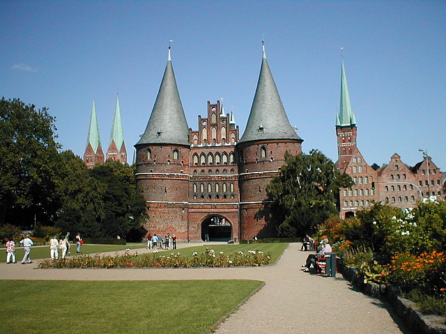

Lübeck
- city in Schleswig-Holstein, Germany
Hiking in Lübeck
Lübeck, located in northern Germany, is known for its rich medieval history, beautiful architecture, and proximity to the scenic Baltic Sea. While it may not be primarily recognized as a hiking destination, there are still several opportunities for outdoor enthusiasts to enjoy nature and explore the region through hiking....
- Country:
- Postal Code: 23552–23570
- Local Dialing Code: 451; 4508; 4502
- Licence Plate Code: HL
- Coordinates: 53° 52' 11" N, 10° 41' 11" E
- GPS tracks (wikiloc): [Link]
- AboveSeaLevel: 13 м m
- Area: 214.21 sq km
- Population: 216709
- Web site: [Link]
Plön District
- German district
Hiking in Plön District
Plön, located in Schleswig-Holstein, Germany, is known for its beautiful landscapes, scenic lakes, and rich history, making it a great destination for hiking enthusiasts. Here are some key highlights about hiking in the Plön district:...
- Country:
- Coordinates: 54° 15' 0" N, 10° 25' 12" E
- GPS tracks (wikiloc): [Link]
- AboveSeaLevel: 28 м m
- Area: 1082.7 sq km
- Web site: [Link]
Segeberg
- district in Germany
Hiking in Segeberg
Segeberg, located in Schleswig-Holstein, Germany, offers a variety of hiking opportunities amidst its beautiful natural landscapes. The area is renowned for its rolling hills, dense forests, and picturesque lakes, making it a great destination for outdoor enthusiasts....
- Country:
- Licence Plate Code: SE
- Coordinates: 53° 55' 12" N, 10° 10' 12" E
- GPS tracks (wikiloc): [Link]
- AboveSeaLevel: 37 м m
- Area: 1344.39 sq km
- Population: 272235
- Web site: [Link]

Stormarn
- German district
Hiking in Stormarn
Stormarn is a district in the federal state of Schleswig-Holstein, Germany, known for its beautiful landscapes, lush forests, and charming villages. Hiking in this area offers a variety of trails suitable for all levels of experience, catering to both casual walkers and avid trekkers. Here are some highlights and tips for hiking in Stormarn:...
- Country:
- Licence Plate Code: OD
- Coordinates: 53° 45' 0" N, 10° 19' 48" E
- GPS tracks (wikiloc): [Link]
- AboveSeaLevel: 34 м m
- Area: 766.33 sq km
- Population: 236705
- Web site: [Link]