Ploufragan (Ploufragan)

- commune in Côtes-d'Armor, France
- Country:

- Postal Code: 22440
- Coordinates: 48° 29' 22" N, 2° 47' 45" E


- GPS tracks (wikiloc): [Link]
- Area: 27.06 sq km
- Population: 11326
- Web site: http://www.ploufragan.fr
- Wikipedia en: wiki(en)
- Wikipedia: wiki(fr)
- Wikidata storage: Wikidata: Q225204
- Wikipedia Commons Category: [Link]
- Freebase ID: [/m/03hgyzm]
- GeoNames ID: Alt: [2986678]
- SIREN number: [212202154]
- BnF ID: [15251214q]
- VIAF ID: Alt: [133839843]
- GND ID: Alt: [4249386-9]
- Library of Congress authority ID: Alt: [n93008561]
- SUDOC authorities ID: [142997846]
- Twitter username: Alt: [VillePloufragan]
- INSEE municipality code: 22215
Shares border with regions:

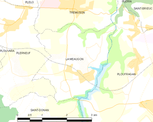
La Méaugon
- commune in Côtes-d'Armor, France
- Country:
- Postal Code: 22440
- Coordinates: 48° 29' 55" N, 2° 50' 18" E
- GPS tracks (wikiloc): [Link]
- Area: 6.78 sq km
- Population: 1279
- Web site: [Link]


Saint-Donan
- commune in Côtes-d'Armor, France
- Country:
- Postal Code: 22800
- Coordinates: 48° 28' 11" N, 2° 53' 7" E
- GPS tracks (wikiloc): [Link]
- Area: 22.92 sq km
- Population: 1440
- Web site: [Link]

Trémuson
- commune in Côtes-d'Armor, France
- Country:
- Postal Code: 22440
- Coordinates: 48° 31' 26" N, 2° 50' 58" E
- GPS tracks (wikiloc): [Link]
- Area: 6.31 sq km
- Population: 2015

Plérin
- commune in Côtes-d'Armor, France
- Country:
- Postal Code: 22190
- Coordinates: 48° 32' 4" N, 2° 46' 15" E
- GPS tracks (wikiloc): [Link]
- Area: 27.72 sq km
- Population: 14032
- Web site: [Link]


Plaine-Haute
- commune in Côtes-d'Armor, France
- Country:
- Postal Code: 22800
- Coordinates: 48° 26' 43" N, 2° 51' 13" E
- GPS tracks (wikiloc): [Link]
- Area: 15.29 sq km
- Population: 1577

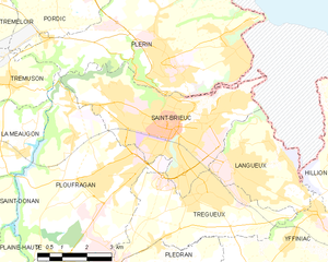
Saint-Brieuc
- commune in Côtes-d'Armor, France
- Country:
- Postal Code: 22000
- Coordinates: 48° 30' 54" N, 2° 46' 6" E
- GPS tracks (wikiloc): [Link]
- AboveSeaLevel: 134 м m
- Area: 21.88 sq km
- Population: 45105
- Web site: [Link]

Plédran
- commune in Côtes-d'Armor, France
- Country:
- Postal Code: 22960
- Coordinates: 48° 26' 45" N, 2° 44' 46" E
- GPS tracks (wikiloc): [Link]
- Area: 34.71 sq km
- Population: 6491


Trégueux
- commune in Côtes-d'Armor, France
- Country:
- Postal Code: 22950
- Coordinates: 48° 29' 26" N, 2° 44' 17" E
- GPS tracks (wikiloc): [Link]
- AboveSeaLevel: 120 м m
- Area: 14.57 sq km
- Population: 8411
- Web site: [Link]


Saint-Julien
- commune in Côtes-d'Armor, France
- Country:
- Postal Code: 22940
- Coordinates: 48° 27' 9" N, 2° 48' 59" E
- GPS tracks (wikiloc): [Link]
- Area: 5.69 sq km
- Population: 2062
- Web site: [Link]