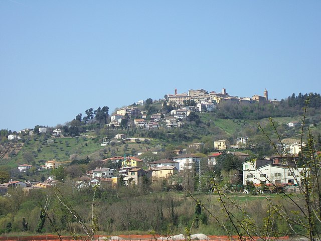
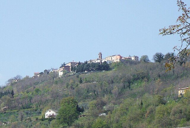
Poggio San Marcello (Poggio San Marcello)
.svg)
- Italian comune
 Hiking in Poggio San Marcello
Poggio San Marcello is a charming village located in the Marche region of Italy. Situated amidst beautiful hills and lush landscapes, it offers a variety of hiking opportunities for both beginners and experienced hikers. Here are some highlights and tips for hiking in and around Poggio San Marcello:
Scenic Trails
-
Nature Walks: The area boasts several well-marked trails that traverse vineyards, olive groves, and forests. The scenic views offer a glimpse of the rolling hills characteristic of the Marche region.
-
Historical Paths: Some trails might take you through historical areas, allowing you to enjoy picturesque landscapes while also discovering local history and culture.
-
Gran Sasso National Park: While Poggio San Marcello is not within the park itself, it’s a relatively short drive to the Gran Sasso, where you can explore more challenging hikes and stunning mountain scenery.
Hiking Tips
-
Season: Spring and autumn are ideal for hiking in this region, as the weather is usually mild and the scenery is particularly beautiful during these seasons.
-
Equipment: Ensure you have proper footwear, as some trails can be uneven. A good pair of hiking boots will enhance your comfort and safety on the trails.
-
Hydration & Snacks: Carry plenty of water and some snacks, especially if you plan to be out for several hours. There might not be amenities on some trails.
-
Local Guides: If you're unfamiliar with the area, consider hiring a local guide. They can provide insights into the natural and cultural significance of the region.
Additional Attractions
-
Villages: After your hike, explore the local villages, enjoy some authentic Italian cuisine, and visit local wineries.
-
Wildlife: Keep an eye out for local wildlife, including various bird species and other fauna native to the Marche region.
Safety
Always inform someone about your hiking plans. Carry a map or GPS, especially if you’re venturing on less marked paths. It's important to be aware of your physical limits and the weather conditions to ensure a safe and enjoyable experience.
Hiking in Poggio San Marcello can be a delightful adventure, with its stunning scenery and rich cultural heritage waiting to be explored! Enjoy your hike!
- Country:

- Postal Code: 60030
- Local Dialing Code: 0731
- Licence Plate Code: AN
- Coordinates: 43° 30' 42" N, 13° 4' 38" E


- GPS tracks (wikiloc): [Link]
- AboveSeaLevel: 385 м m
- Area: 13.36 sq km
- Population: 681
- Web site: http://www.comune.poggiosanmarcello.an.it/hh/index.php
- Wikipedia en: wiki(en)
- Wikipedia: wiki(it)
- Wikidata storage: Wikidata: Q124620
- Wikipedia Commons Category: [Link]
- Freebase ID: [/m/0gl5_j]
- GeoNames ID: Alt: [6543590]
- OSM relation ID: [49127]
- UN/LOCODE: [ITPS2]
- ISTAT ID: 042037
- Italian cadastre code: G771
Shares border with regions:
Belvedere Ostrense
- Italian comune
Hiking in Belvedere Ostrense
Belvedere Ostrense is a picturesque village located in the Marche region of Italy. This charming area offers several hiking opportunities that glide through lush green landscapes, rolling hills, and ancient historical sites. Here are some highlights of hiking in Belvedere Ostrense:...
- Country:
- Postal Code: 60030
- Local Dialing Code: 0731
- Licence Plate Code: AN
- Coordinates: 43° 34' 50" N, 13° 10' 0" E
- GPS tracks (wikiloc): [Link]
- AboveSeaLevel: 251 м m
- Area: 29.45 sq km
- Population: 2203
- Web site: [Link]

Castelplanio
- Italian comune
Hiking in Castelplanio
Castelplanio, located in the Marche region of Italy, is a wonderful destination for hiking enthusiasts. The area is characterized by its stunning natural landscapes, rolling hills, and rich cultural heritage. Here are some highlights of hiking in Castelplanio:...
- Country:
- Postal Code: 60031
- Local Dialing Code: 0731
- Licence Plate Code: AN
- Coordinates: 43° 29' 40" N, 13° 4' 51" E
- GPS tracks (wikiloc): [Link]
- AboveSeaLevel: 305 м m
- Area: 15.32 sq km
- Population: 3524
- Web site: [Link]


Montecarotto
- Italian comune
Hiking in Montecarotto
Montecarotto, located in the Marche region of Italy, is a beautiful destination for hiking enthusiasts. This charming town is surrounded by picturesque landscapes, rolling hills, vineyards, and olive groves, providing a fantastic backdrop for outdoor activities. Here are some highlights and tips for hiking in Montecarotto:...
- Country:
- Postal Code: 60036
- Local Dialing Code: 0731
- Licence Plate Code: AN
- Coordinates: 43° 31' 35" N, 13° 3' 52" E
- GPS tracks (wikiloc): [Link]
- AboveSeaLevel: 385 м m
- Area: 24.39 sq km
- Population: 1920
- Web site: [Link]

Rosora
- Italian comune
Hiking in Rosora
Rosora is a charming town located in the Marche region of Italy, surrounded by picturesque landscapes and rolling hills. It offers several hiking opportunities for outdoor enthusiasts who wish to explore the natural beauty of the area....
- Country:
- Postal Code: 60030
- Local Dialing Code: 0731
- Licence Plate Code: AN
- Coordinates: 43° 28' 58" N, 13° 4' 9" E
- GPS tracks (wikiloc): [Link]
- AboveSeaLevel: 381 м m
- Area: 9.41 sq km
- Population: 1956
- Web site: [Link]