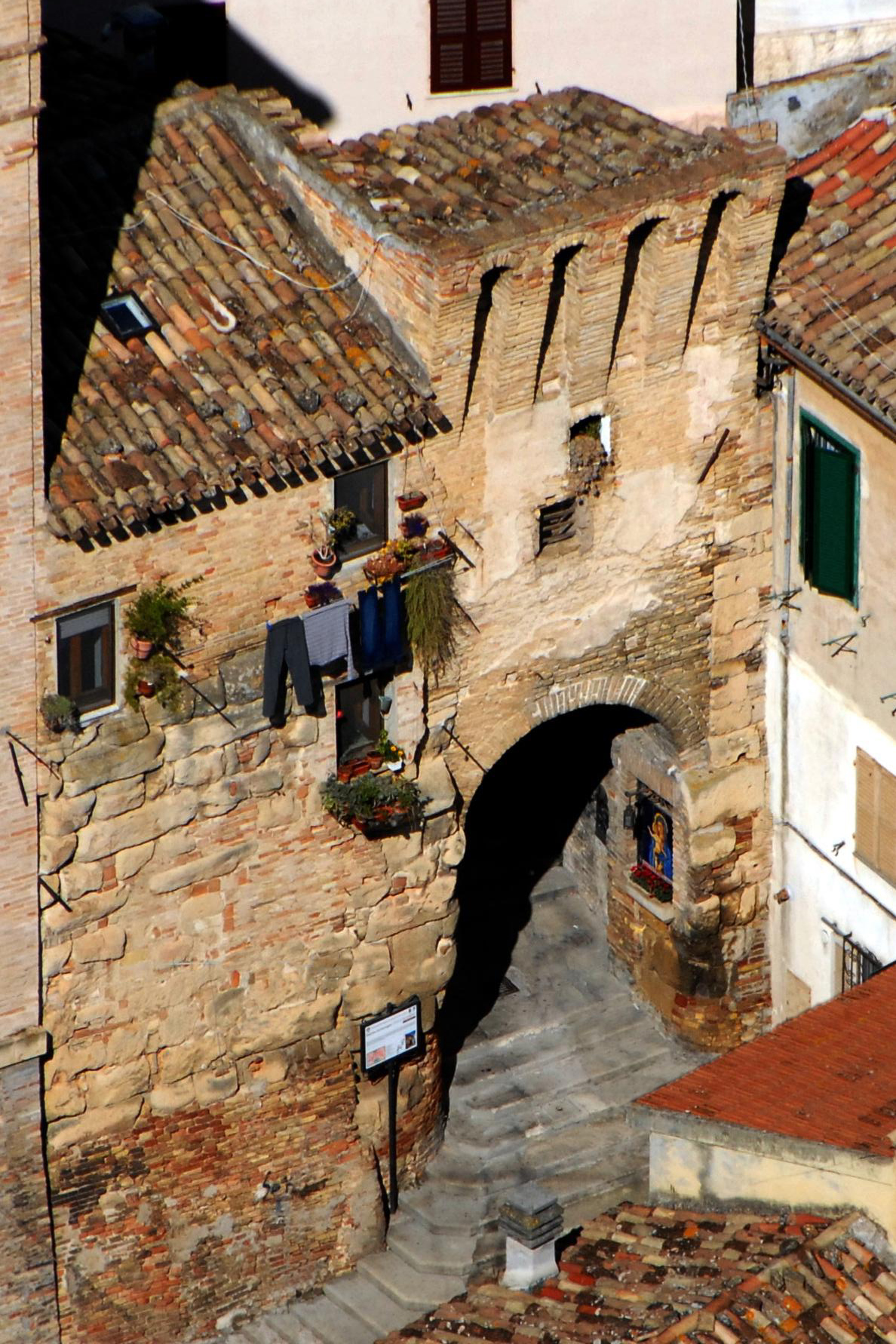
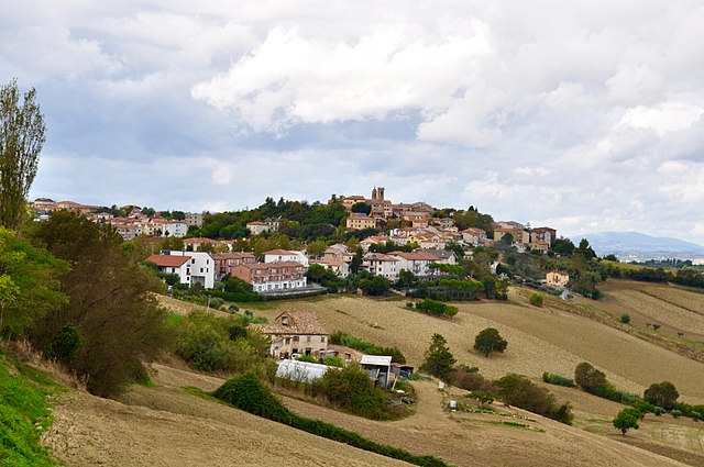
Polverigi (Polverigi)
.svg)
- Italian comune
 Hiking in Polverigi
Polverigi is a charming town located in the Marche region of Italy, known for its beautiful landscapes, historical sites, and proximity to natural parks. When hiking in and around Polverigi, you can expect a variety of trails that cater to different experience levels, offering stunning views of the rolling hills and countryside typical of the region.
Key Hiking Areas and Trails:
-
Parco Naturale del Monte Conero: While this park is not directly in Polverigi, it's relatively close and offers breathtaking coastal views, rugged cliffs, and a variety of hiking trails that range from easy to challenging.
-
The Hills Around Polverigi: There are several local paths that offer moderate hikes through vineyards, olive groves, and woodlands, allowing hikers to enjoy the peaceful rural landscape and perhaps even stop by local agriturismos for tastings.
-
Cultural Trails: Some trails may lead you to historical sites, such as old monasteries and castles, providing an enriching experience that combines hiking with cultural exploration.
Tips for Hiking in Polverigi:
-
Gear: Ensure you have appropriate hiking shoes, especially if you’re venturing on rocky or uneven trails. A good backpack, water, and snacks are essential.
-
Navigation: While some paths can be well-marked, it’s helpful to have a local hiking map or a GPS device/app to ensure you stay on track.
-
Weather: Check the weather forecast before heading out, as conditions can change rapidly. Spring and fall are particularly pleasant for hiking in this region.
-
Local Guides: Consider hiring a local guide if you're unfamiliar with the area or want to learn more about the flora, fauna, and history along the trails.
-
Respect Nature: Stay on marked paths, carry out what you bring in, and be considerate of wildlife and other hikers.
Conclusion
Hiking in Polverigi offers not just physical activity but also a chance to immerse yourself in the natural beauty and rich culture of the Marche region. Whether you are a beginner or an experienced hiker, there are plenty of opportunities to enjoy the scenic landscapes and explore the local heritage.
- Country:

- Postal Code: 60020
- Local Dialing Code: 071
- Licence Plate Code: AN
- Coordinates: 43° 31' 31" N, 13° 23' 39" E


- GPS tracks (wikiloc): [Link]
- AboveSeaLevel: 148 м m
- Area: 24.98 sq km
- Population: 4565
- Web site: http://www.comune.polverigi.an.it/
- Wikipedia en: wiki(en)
- Wikipedia: wiki(it)
- Wikidata storage: Wikidata: Q124662
- Wikipedia Commons Category: [Link]
- Freebase ID: [/m/0gl5_x]
- GeoNames ID: Alt: [6541061]
- VIAF ID: Alt: [146642008]
- OSM relation ID: [42483]
- WOEID: [720859]
- UN/LOCODE: [ITPLE]
- ISTAT ID: 042038
- Italian cadastre code: G803
Shares border with regions:
Agugliano
- Italian comune
Hiking in Agugliano
Agugliano is a small town located in the Marche region of Italy, surrounded by beautiful landscapes that are ideal for hiking enthusiasts. Here’s what you can expect when hiking in and around Agugliano:...
- Country:
- Postal Code: 60020
- Local Dialing Code: 071
- Licence Plate Code: AN
- Coordinates: 43° 32' 36" N, 13° 23' 10" E
- GPS tracks (wikiloc): [Link]
- AboveSeaLevel: 203 м m
- Area: 21.89 sq km
- Population: 4799
- Web site: [Link]


Offagna
- Italian comune
Hiking in Offagna
Offagna is a lovely medieval village located in the Marche region of Italy, known for its picturesque views, historical architecture, and natural beauty. Hiking in and around Offagna offers a wonderful blend of cultural exploration and outdoor adventure. Here are some highlights to consider when hiking in this area:...
- Country:
- Postal Code: 60020
- Local Dialing Code: 071
- Licence Plate Code: AN
- Coordinates: 43° 31' 38" N, 13° 26' 29" E
- GPS tracks (wikiloc): [Link]
- AboveSeaLevel: 306 м m
- Area: 10.63 sq km
- Population: 1992
- Web site: [Link]

Osimo
- Italian comune
Hiking in Osimo
Osimo is a charming town in the Marche region of Italy, known for its rich history, beautiful architecture, and stunning landscapes. While it may not be as famous as some other hiking destinations, the surrounding areas offer a variety of hiking opportunities that can cater to different skill levels....
- Country:
- Postal Code: 60027
- Local Dialing Code: 071
- Licence Plate Code: AN
- Coordinates: 43° 29' 10" N, 13° 28' 56" E
- GPS tracks (wikiloc): [Link]
- AboveSeaLevel: 265 м m
- Area: 106.74 sq km
- Population: 35071
- Web site: [Link]

Santa Maria Nuova, Marche
- Italian comune
Hiking in Santa Maria Nuova, Marche
Santa Maria Nuova, located in the Marche region of Italy, is surrounded by beautiful landscapes perfect for hiking enthusiasts. The area offers a combination of rolling hills, picturesque valleys, and a chance to explore historical and cultural landmarks....
- Country:
- Postal Code: 60030
- Local Dialing Code: 0731
- Licence Plate Code: AN
- Coordinates: 43° 29' 45" N, 13° 18' 39" E
- GPS tracks (wikiloc): [Link]
- AboveSeaLevel: 249 м m
- Area: 18.29 sq km
- Population: 4146
- Web site: [Link]


Iesi
- Italian comune
Hiking in Iesi
Iesi, located in the Marche region of Italy, offers a variety of hiking opportunities with its scenic landscapes, historical sites, and charming countryside. Here are some highlights and tips for hiking in and around Iesi:...
- Country:
- Postal Code: 60035
- Local Dialing Code: 0731
- Licence Plate Code: AN
- Coordinates: 43° 31' 22" N, 13° 14' 38" E
- GPS tracks (wikiloc): [Link]
- AboveSeaLevel: 97 м m
- Area: 107.73 sq km
- Population: 40210
- Web site: [Link]


Ancona
- Italian city in the Marches region.
Hiking in Ancona
Ancona, located on the Adriatic coast of Italy, is a beautiful destination for hiking, offering a mix of coastal trails, scenic landscapes, and historical sites. Here are some highlights for hiking in and around Ancona:...
- Country:
- Postal Code: 60121–60131; 60100
- Local Dialing Code: 071
- Licence Plate Code: AN
- Coordinates: 43° 37' 0" N, 13° 31' 0" E
- GPS tracks (wikiloc): [Link]
- AboveSeaLevel: 16 м m
- Area: 124.84 sq km
- Population: 100721
- Web site: [Link]