Pont-Farcy (Pont-Farcy)

- former commune in Manche, France
- Country:

- Postal Code: 14380
- Coordinates: 48° 56' 10" N, 1° 2' 10" E


- GPS tracks (wikiloc): [Link]
- AboveSeaLevel: 86 м m
- Area: 13.45 sq km
- Population: 537
- Web site: http://www.pont-farcy.fr
- Wikipedia en: wiki(en)
- Wikipedia: wiki(fr)
- Wikidata storage: Wikidata: Q478445
- Wikipedia Commons Category: [Link]
- Freebase ID: [/m/031r75]
- Freebase ID: [/m/031r75]
- GeoNames ID: Alt: [6615910]
- GeoNames ID: Alt: [6615910]
- SIREN number: [211405139]
- SIREN number: [211405139]
- BnF ID: [15247923v]
- BnF ID: [15247923v]
- PACTOLS thesaurus ID: [pcrtvy9eFzAQsR]
- PACTOLS thesaurus ID: [pcrtvy9eFzAQsR]
- INSEE municipality code: 14513
- INSEE municipality code: 14513
Shares border with regions:


Beuvrigny
- commune in Manche, France
- Country:
- Postal Code: 50420
- Coordinates: 48° 58' 5" N, 1° 0' 16" E
- GPS tracks (wikiloc): [Link]
- Area: 6.77 sq km
- Population: 134


Fourneaux
- commune in Manche, France
- Country:
- Postal Code: 50420
- Coordinates: 48° 57' 52" N, 1° 2' 10" E
- GPS tracks (wikiloc): [Link]
- Area: 3.34 sq km
- Population: 150


Guilberville
- former commune in Manche, France
- Country:
- Postal Code: 50160
- Coordinates: 48° 59' 18" N, 0° 56' 51" E
- GPS tracks (wikiloc): [Link]
- Area: 22.15 sq km
- Population: 1209
- Web site: [Link]


Gouvets
- commune in Manche, France
- Country:
- Postal Code: 50420
- Coordinates: 48° 55' 57" N, 1° 5' 47" E
- GPS tracks (wikiloc): [Link]
- Area: 11.01 sq km
- Population: 268

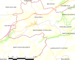
Sainte-Marie-Outre-l'Eau
- commune in Calvados, France
- Country:
- Postal Code: 14380
- Coordinates: 48° 56' 8" N, 1° 1' 26" E
- GPS tracks (wikiloc): [Link]
- Area: 5.75 sq km
- Population: 118


Pont-Bellanger
- commune in Calvados, France
- Country:
- Postal Code: 14380
- Coordinates: 48° 55' 54" N, 0° 58' 48" E
- GPS tracks (wikiloc): [Link]
- Area: 3.54 sq km
- Population: 64


Saint-Vigor-des-Monts
- commune in Manche, France
- Country:
- Postal Code: 50420
- Coordinates: 48° 54' 38" N, 1° 5' 12" E
- GPS tracks (wikiloc): [Link]
- Area: 15.74 sq km
- Population: 287

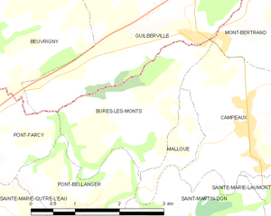
Bures-les-Monts
- former commune in Calvados, France
- Country:
- Postal Code: 14350
- Coordinates: 48° 56' 48" N, 0° 57' 55" E
- GPS tracks (wikiloc): [Link]
- Area: 5.21 sq km
- Population: 151


Tessy-sur-Vire
- former commune in Manche, France
- Country:
- Postal Code: 50420
- Coordinates: 48° 58' 28" N, 1° 3' 39" E
- GPS tracks (wikiloc): [Link]
- Area: 15.9 sq km
- Population: 1431
- Web site: [Link]