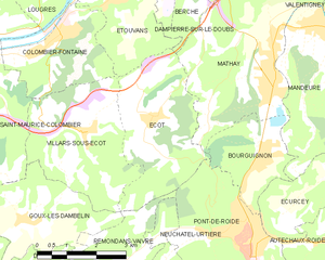
Pont-de-Roide-Vermondans (Pont-de-Roide-Vermondans)

- commune in Doubs, France
 Hiking in Pont-de-Roide-Vermondans
Pont-de-Roide-Vermondans is a picturesque area located in the Doubs department in the Bourgogne-Franche-Comté region of France. It's known for its natural beauty and landscapes, making it a great destination for hiking enthusiasts. Here are some details to consider when hiking in this area:
Trails and Routes
- Diversity of Trails: The area offers a variety of trails ranging from easy walks to more challenging hikes. Some paths are suited for beginners, while others may require more experience.
- Scenic Views: Many trails take you through lush forests, alongside rivers, and across rolling hills, providing beautiful views of the surrounding landscape.
- Marked Trails: Look for the PR (Petite Randonnée) markers to navigate local hiking paths.
Flora and Fauna
- Biodiversity: The region has a rich ecological environment, with a variety of plant and animal species. Hikers might spot local wildlife and enjoy the diverse plant life along the trails.
Best Hiking Seasons
- Spring and Fall: These seasons are often the best times to hike in Pont-de-Roide-Vermondans. The weather is usually mild, and nature is vibrant, with blooming flowers in spring and colorful foliage in fall.
- Summer: While summer can be hot, it's also a popular time for hiking. Just be sure to stay hydrated and take breaks when needed.
- Winter: Depending on snow conditions, some trails may be less accessible in winter, but snowy landscapes can provide a picturesque hiking experience.
Preparation Tips
- Gear: Wear appropriate hiking shoes and clothing for the weather. Consider bringing trekking poles for stability, especially on uneven terrain.
- Supplies: Carry enough water, snacks, and a first-aid kit. It's also a good idea to have a map or a GPS device to stay oriented.
- Local Regulations: Check for any local regulations or guidelines regarding trail usage, as some areas may have restrictions to preserve natural habitats.
Additional Activities
- Local Attractions: Besides hiking, you might want to explore local cultural sites, historical landmarks, or nearby villages for a more comprehensive experience of the region.
- Photography: With its stunning landscapes, Pont-de-Roide-Vermondans is also an excellent location for photography. Capture the natural beauty, wildlife, and unique features of the trails.
Make sure to plan your hike according to your ability level and the time you have available. Enjoy the beautiful scenery and the tranquility of nature in Pont-de-Roide-Vermondans!
- Country:

- Postal Code: 25150
- Coordinates: 47° 23' 5" N, 6° 46' 12" E


- GPS tracks (wikiloc): [Link]
- Area: 13.58 sq km
- Population: 4215
- Web site: http://www.ville-pontderoide-vermondans.com
- Wikipedia en: wiki(en)
- Wikipedia: wiki(fr)
- Wikidata storage: Wikidata: Q841396
- Wikipedia Commons Category: [Link]
- Freebase ID: [/m/03mhc3y]
- Freebase ID: [/m/03mhc3y]
- GeoNames ID: Alt: [2986237]
- GeoNames ID: Alt: [2986237]
- SIREN number: [200037182]
- SIREN number: [200037182]
- BnF ID: [15252689z]
- BnF ID: [15252689z]
- VIAF ID: Alt: [239652423]
- VIAF ID: Alt: [239652423]
- GND ID: Alt: [4651598-7]
- GND ID: Alt: [4651598-7]
- PACTOLS thesaurus ID: [pcrt0D2Td1f1e0]
- PACTOLS thesaurus ID: [pcrt0D2Td1f1e0]
- INSEE municipality code: 25463
- INSEE municipality code: 25463
Shares border with regions:

Écot
- commune in Doubs, France
Hiking in Écot
Écot is a charming area located in the Vosges department of northeastern France, known for its beautiful natural landscapes and serene hiking opportunities. Hiking in Écot offers a chance to explore lush forests, rolling hills, and scenic viewpoints....
- Country:
- Postal Code: 25150
- Coordinates: 47° 25' 34" N, 6° 43' 57" E
- GPS tracks (wikiloc): [Link]
- Area: 11.02 sq km
- Population: 503


Écurcey
- commune in Doubs, France
Hiking in Écurcey
Écurcey is a small commune located in the Normandy region of France, known for its picturesque landscapes and rural charm. Although Écurcey may not be widely recognized as a major hiking destination, it is surrounded by beautiful natural areas that can be explored....
- Country:
- Postal Code: 25150
- Coordinates: 47° 24' 19" N, 6° 48' 45" E
- GPS tracks (wikiloc): [Link]
- Area: 7.43 sq km
- Population: 273


Noirefontaine
- commune in Doubs, France
Hiking in Noirefontaine
Noirefontaine is an area in the French region of Auvergne-Rhône-Alpes, known for its scenic beauty and great opportunities for hiking. This region boasts a mix of lush forests, rolling hills, and picturesque landscapes, making it an ideal destination for outdoor enthusiasts....
- Country:
- Postal Code: 25190
- Coordinates: 47° 20' 56" N, 6° 45' 43" E
- GPS tracks (wikiloc): [Link]
- Area: 3.35 sq km
- Population: 396


Autechaux-Roide
- commune in Doubs, France
Hiking in Autechaux-Roide
Autechaux-Roide, located in the Doubs department in the Bourgogne-Franche-Comté region of France, offers a range of beautiful hiking opportunities, especially for those who appreciate nature and scenic landscapes....
- Country:
- Postal Code: 25150
- Coordinates: 47° 23' 31" N, 6° 48' 53" E
- GPS tracks (wikiloc): [Link]
- Area: 6.56 sq km
- Population: 534


Bourguignon
- commune in Doubs, France
Hiking in Bourguignon
Bourguignon is a charming commune located in the Doubs department in the Bourgogne-Franche-Comté region of eastern France. While it may not be as well-known as some other hiking destinations, it offers picturesque landscapes and opportunities for outdoor adventures in the surrounding areas....
- Country:
- Postal Code: 25150
- Coordinates: 47° 24' 48" N, 6° 46' 48" E
- GPS tracks (wikiloc): [Link]
- Area: 5.56 sq km
- Population: 946


Pierrefontaine-lès-Blamont
- commune in Doubs, France
Hiking in Pierrefontaine-lès-Blamont
Pierrefontaine-lès-Blamont, located in the Doubs department of France, offers a picturesque setting for hiking enthusiasts. The area is characterized by its rolling hills, lush forests, and scenic landscapes, making it an ideal destination for nature lovers....
- Country:
- Postal Code: 25310
- Coordinates: 47° 22' 32" N, 6° 50' 21" E
- GPS tracks (wikiloc): [Link]
- Area: 8.96 sq km
- Population: 445

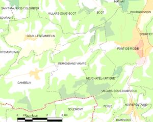
Rémondans-Vaivre
- commune in Doubs, France
Hiking in Rémondans-Vaivre
Rémondans-Vaivre is a charming commune located in the eastern part of France, in the Doubs department. It offers a picturesque landscape that is great for hiking enthusiasts who want to explore the natural beauty and tranquility of the region. Here are a few highlights about hiking in Rémondans-Vaivre:...
- Country:
- Postal Code: 25150
- Coordinates: 47° 22' 31" N, 6° 42' 48" E
- GPS tracks (wikiloc): [Link]
- AboveSeaLevel: 365 м m
- Area: 9.19 sq km
- Population: 233


Neuchâtel-Urtière
- commune in Doubs, France
Hiking in Neuchâtel-Urtière
Neuchâtel-Urtière, located in the Canton of Neuchâtel in Switzerland, offers some beautiful hiking opportunities in a picturesque setting. The region features a combination of rolling hills, dense forests, and stunning views of Lake Neuchâtel and the surrounding Jura mountain range....
- Country:
- Postal Code: 25150
- Coordinates: 47° 22' 29" N, 6° 43' 49" E
- GPS tracks (wikiloc): [Link]
- Area: 6.21 sq km
- Population: 185


Villars-sous-Dampjoux
- commune in Doubs, France
Hiking in Villars-sous-Dampjoux
Villars-sous-Dampjoux is a charming village located in the Doubs department of France, nestled in the Jura Mountains. The region is known for its stunning natural beauty, making it an excellent spot for hiking enthusiasts....
- Country:
- Postal Code: 25190
- Coordinates: 47° 20' 57" N, 6° 45' 24" E
- GPS tracks (wikiloc): [Link]
- Area: 3.06 sq km
- Population: 367


Montécheroux
- commune in Doubs, France
Hiking in Montécheroux
Montécheroux is a charming commune located in the Doubs department in the Bourgogne-Franche-Comté region of eastern France. Nestled in a picturesque landscape that features rolling hills and dense forests, it offers a variety of hiking opportunities for both beginners and experienced hikers....
- Country:
- Postal Code: 25190
- Coordinates: 47° 21' 0" N, 6° 48' 22" E
- GPS tracks (wikiloc): [Link]
- Area: 13.13 sq km
- Population: 581