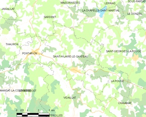
Pontarion (Pontarion)
- commune in Creuse, France
- Country:

- Postal Code: 23250
- Coordinates: 45° 59' 50" N, 1° 50' 59" E


- GPS tracks (wikiloc): [Link]
- Area: 5.25 sq km
- Population: 366
- Wikipedia en: wiki(en)
- Wikipedia: wiki(fr)
- Wikidata storage: Wikidata: Q1082465
- Wikipedia Commons Category: [Link]
- Freebase ID: [/m/03mfk3t]
- Freebase ID: [/m/03mfk3t]
- GeoNames ID: Alt: [2986303]
- GeoNames ID: Alt: [2986303]
- SIREN number: [212315501]
- SIREN number: [212315501]
- BnF ID: [15251542s]
- BnF ID: [15251542s]
- VIAF ID: Alt: [136239050]
- VIAF ID: Alt: [136239050]
- Library of Congress authority ID: Alt: [n2003042417]
- Library of Congress authority ID: Alt: [n2003042417]
- Digital Atlas of the Roman Empire ID: [14451]
- Digital Atlas of the Roman Empire ID: [14451]
- INSEE municipality code: 23155
- INSEE municipality code: 23155
Shares border with regions:


Saint-Hilaire-le-Château
- commune in Creuse, France
- Country:

- Postal Code: 23250
- Coordinates: 45° 58' 58" N, 1° 53' 49" E


- GPS tracks (wikiloc): [Link]
- Area: 19.59 sq km
- Population: 236
Thauron
- commune in Creuse, France
- Country:

- Postal Code: 23250
- Coordinates: 46° 0' 0" N, 1° 49' 4" E


- GPS tracks (wikiloc): [Link]
- Area: 22.34 sq km
- Population: 177


Soubrebost
- commune in Creuse, France
- Country:

- Postal Code: 23250
- Coordinates: 45° 57' 28" N, 1° 50' 35" E


- GPS tracks (wikiloc): [Link]
- Area: 20.76 sq km
- Population: 136


Sardent
- commune in Creuse, France
- Country:

- Postal Code: 23250
- Coordinates: 46° 3' 2" N, 1° 51' 20" E


- GPS tracks (wikiloc): [Link]
- Area: 41.11 sq km
- Population: 783
- Web site: [Link]
